
Myreton Hill


Enclosure (Post Medieval), Farmstead (Post Medieval), Field System (Post Medieval), Track (Post Medieval)
Site Name Myreton Hill
Classification Enclosure (Post Medieval), Farmstead (Post Medieval), Field System (Post Medieval), Track (Post Medieval)
Canmore ID 145356
Site Number NS89NW 88
NGR NS 8495 9773
Datum OSGB36 - NGR
Permalink http://canmore.org.uk/site/145356


- Council Clackmannan
- Parish Alva
- Former Region Central
- Former District Clackmannan
- Former County Clackmannanshire
Field Visit (24 April 1997)
NS87NW 88 8495 9773
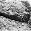
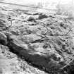
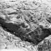
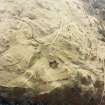
This farmstead is situated at the back of a grassy terrace in the broken ground on the W flank of Myreton Hill. It comprises the footings of two rectangular buildings, set at right-angles to each other, and four enclosures. The northern building (MENS97 33) is the larger, measuring 14.5m from E to W by 4.3m transversely within faced-rubble footings, 0.9m in thickness and 0.4m in height. The interior is divided into two and there is an entrance in the S. The second building (MENS97) is smaller, measuring 8.9m from N to S by 4m internally, with an extension 3.8m in length to the S. A trackway running along the back of the terrace skirts along the E of the buildings, disappearing under the line of the modern farm track to the N.
Every reasonably flat piece of ground around the farmstead appears to have been cultivated, although parts of the terrace have recently been improved for pasture, slighting some patches of rig. The lower edge of the cultivated ground is marked by a lynchet on the break of slope above the Menstrie Burn. In two places (NS 8479 9780 and 8482 9750) there are also terraces which have been levelled into the steep sides of the gorge of the Menstrie Burn which appear to have been cultivated. Banks, predominately running along breaks of slopes and terraces to the N of the farmstead (NS 8495 9795), define a fragmentary field-system of plots measuring up to 140m by 70m across. A similar, less fragmented field-system lies along the line of a substantial field bank which runs along the back of the terrace to the S of the farmstead (NS 8500 9750). This comprises roughly rectangular plots, aligned on two axes, from E to W and NNW to SSE according to the lie of the land, which also contain rig, although some of this has been reduced by ploughing. Within, and at the edge of this area of cultivated ground there are four earth and stone banked enclosures, measuring about 10m across (NS 8497 9795; 8492 9755; 8503 9729; 8516 9744), and occupying sheltered locations in the lee of rock outcrops which have also been utilised as part of the line of the enclosure. Other, similar enclosures are littered across the hillside (see NS89NE 47)
(MENS97 33, 34)
Visited by RCHAMS (DCC) 24 April 1997

