 |
On-line Digital Images |
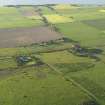
DP 080283 |
RCAHMS Aerial Photography Digital |
Oblique aerial view of the remains of the field system with Peddieston House beyond, taken from the SW. |
29/5/2009 |
Item Level |
|
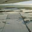 |
On-line Digital Images |
SC 1906915 |
Papers of James Sloan Bone, landscape historian, Inverness, Highland, Scotland |
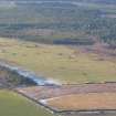
Oblique aerial view of Muirton, Black Isle, looking S. |
2000 |
Item Level |
|
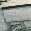 |
On-line Digital Images |
SC 1906917 |
Papers of James Sloan Bone, landscape historian, Inverness, Highland, Scotland |
Oblique aerial view of part of the Glenurquhart / Whitebog Wood field system, Muirton, Black Isle, looking SE. |
2000 |
Item Level |
|
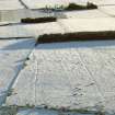 |
On-line Digital Images |
SC 1906918 |
Papers of James Sloan Bone, landscape historian, Inverness, Highland, Scotland |
Oblique aerial view of part of the Glenurquhart / Whitebog Wood field system, Muirton, Black Isle, looking SE. |
2000 |
Item Level |
|
 |
On-line Digital Images |
SC 1944937 |
Papers of James Sloan Bone, landscape historian, Inverness, Highland, Scotland |
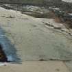
Aerial view of White Bog Wood, SE of Cromarty, Black Isle, looking W. |
13/3/2001 |
Item Level |
|
 |
On-line Digital Images |
DP 341887 |
Papers of James Sloan Bone, landscape historian, Inverness, Highland, Scotland |
An oblique aerial view Whitebog Wood, Glenurquahart, Black Isle, looking SSE. |
17/1/2010 |
Item Level |
|
 |
On-line Digital Images |
DP 342552 |
Papers of James Sloan Bone, landscape historian, Inverness, Highland, Scotland |
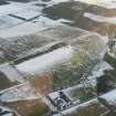
Aerial view of Whitebog Wood mediaeval field system, Rosemarkie, Black Isle, looking NW. |
14/1/2012 |
Item Level |
|
 |
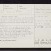
On-line Digital Images |
SC 2366365 |
Records of the Ordnance Survey, Southampton, Hampshire, England |
Glenurquhart, NH76SW 12, Ordnance Survey index card, Recto |
c. 1958 |
Item Level |
|
 |
On-line Digital Images |
SC 2366366 |
Records of the Ordnance Survey, Southampton, Hampshire, England |
Glenurquhart, NH76SW 12, Ordnance Survey index card, Recto |
c. 1958 |
Item Level |
|


