
Pricing Change
New pricing for orders of material from this site will come into place shortly. Charges for supply of digital images, digitisation on demand, prints and licensing will be altered.
Glenurquhart


Field System (Prehistoric), Ring Ditch(S) (Prehistoric)
Site Name Glenurquhart
Classification Field System (Prehistoric), Ring Ditch(S) (Prehistoric)
Alternative Name(s) Battle Site-alleged
Canmore ID 14526
Site Number NH76SW 12
NGR NH 7368 6301
NGR Description Centred on NH 7368 6301
Datum OSGB36 - NGR
Permalink http://canmore.org.uk/site/14526


- Council Highland
- Parish Cromarty
- Former Region Highland
- Former District Ross And Cromarty
- Former County Ross And Cromarty
NH76SW 12 737 630.
(NH 733 625) Site of Battle (NR) (Supposed to have been between the Danes and Scots) (NAT)
OS 6" map, Ross-shire, 2nd ed., (1907)
Nothing further is known of this battle, except that it is the explanation of all the cairns which lie on the surrounding moors.
Name Book 1871.
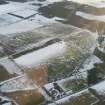
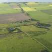
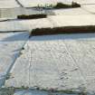
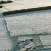
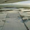
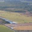
Not a battle site, but a poorly preserved field system centred at NH 737 630 in cleared woodland on a gentle N-facing slope. It comprises denuded stone clearance heaps, field walls and lynchets, which form cultivation plots of a type usually found in association with hut circles. Where best preserved in the NE, two fields measure 20.0m x 15.0m and 30.0m x 20.0m.
Visited by OS (N K B) 23 November 1970.
No change to previous report.
Visited by OS (N K B) 10 January 1978.
Field Visit (May 1979)
Glenurquhart NH 737 630 NH76SW 12
This cairnfield is situated in improved pasture on a ridge NW of Glenurquhart farmhouse and covers an area of 34ha. The cairns vary considerably in size.
RCAHMS 1979, visited May 1979
MS notes in NMRS, RCAMS Emergency Surveys.

