
Quarterside Of Lipney


Byre Dwelling (Post Medieval), Cruck Framed Building (Post Medieval), Farmstead (Post Medieval), Hut(S) (Post Medieval)
Site Name Quarterside Of Lipney
Classification Byre Dwelling (Post Medieval), Cruck Framed Building (Post Medieval), Farmstead (Post Medieval), Hut(S) (Post Medieval)
Canmore ID 145093
Site Number NS89NW 83.02
NGR NS 8447 9819
Datum OSGB36 - NGR
Permalink http://canmore.org.uk/site/145093


- Council Stirling
- Parish Logie (Stirling)
- Former Region Central
- Former District Stirling
- Former County Stirlingshire
Field Visit (19 May 1997)
NS89NW 83.02 8447 9819
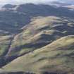
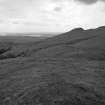
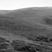
On the E-facing slopes of Dumyat to the N of Lipney, there are two groups of structures and an outlying building to the E; the group to the N comprises a farmstead and that to the S a group of three turf huts.
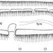
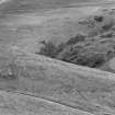
The farmstead (centred at NS 8446 9818) comprises a byre-house, two huts and a rectangular enclosure (MENS97 61-3). The enclosure post-dates both the byre-house and the N of the two huts (MENS97 63), overlying the N wall of the hut and abutting the W wall of the byre-house. The byre-house measures 16m in length by 3m in breadth internally, but narrows at the N end to about 1m. The turf walls are spread to 1.2m in thickness and stand 0.5m in height where best-preserved on the W, but are reduced to as little as 0.15m on the E. The W wall is remarkable for the rare survival of cruck-slots in a turf wall, marked by six dips in the top at intervals of between 2m and 2.8m. This would make the building an eight-bay, cruck-framed house. The house is entered via a gap in the middle of E wall and there is a slight dip indicating a central byre-drain in the N end, which runs out of the E wall near the NE corner. A drain runs along the back of the house where it is set into the slope, which empties downslope at the S end. The two huts are similar in size at about 4m by 2.6m internally within turf walls spread to some 1.5m thick and reduced to 0.3m high. That within the enclosure is built across the contour while the other hut lies outside the enclosure in front of the byre-house.
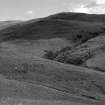
Of the group to the S (centred at NS 8445 9811), two huts (MENS97 166-7) have been reduced to platforms of similar size at 5m and 7m in length by 2.9m and 2.6m in breadth respectively, with slight traces of turf banks around their perimeters in places. The third hut lies to the SE of the southerly of the two platforms and measures 7.1m from NNW to SSE by 4.1m over turf banks, 0.9m thick and 0.3m high (MENS97 146, NS 8446 9810) .
The outlying turf hut or mound (MENS97 60, NS 8454 9827) overlies the head-dyke of the field-system, and measures 3.5m across and 0.4m high.
(MENS97 60-3, 146, 166, 167)
Visited by RCAHMS (PJD, DCC) 19 May 1997

