
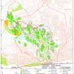
Quarterside Of Lipney


Archaeological Landscape (Medieval) - (Post Medieval)
Site Name Quarterside Of Lipney
Classification Archaeological Landscape (Medieval) - (Post Medieval)
Canmore ID 145091
Site Number NS89NW 83
NGR NS 8460 9807
NGR Description Centred on NS 8460 9807
Datum OSGB36 - NGR
Permalink http://canmore.org.uk/site/145091


- Council Stirling
- Parish Logie (Stirling)
- Former Region Central
- Former District Stirling
- Former County Stirlingshire
Field Visit (20 May 1997)
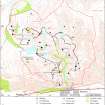
NS89NW 83.00 centred on 8460 9807
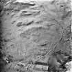
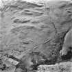
NS89NW 83.01 8451 9784 Farmstead (MENS97 64-8)
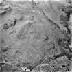
NS89NW 83.02 8447 9819 Farmstead, Huts (MENS97 60-3, 166, 167)
NS89NW 83.03 8460 9813 Field-system; Head-dyke; Rig
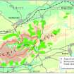
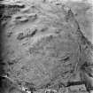
Situated on the slopes above the W bank of the Menstrie Burn and an unnamed burn, there are two farmsteads, set within a palimpsest of field-systems and cultivation remains.
(MENS97 60-8,146, 166-7)
Visited by RCAHMS (JBS, PJD, DCC) 20 May 1997

