
Quarterside Of Lipney


Archaeological Landscape (Post Medieval)
Site Name Quarterside Of Lipney
Classification Archaeological Landscape (Post Medieval)
Alternative Name(s) Dumyat
Canmore ID 145080
Site Number NS89NW 80
NGR NS 8425 9782
Datum OSGB36 - NGR
Permalink http://canmore.org.uk/site/145080


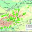


- Council Stirling
- Parish Logie (Stirling)
- Former Region Central
- Former District Stirling
- Former County Stirlingshire
Field Visit (20 May 1997)
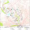
NS89NW 80.00 centred on 8430 9775
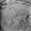
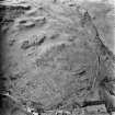
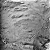
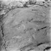
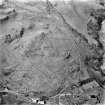
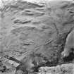
NS89NW 80.01 NS 8425 9782 Field-system; Rig; Enclosures
NS89NW 80.02 NS 8425 9776 Huts (MENS97 69-72)
NS89NW 80.03 NS 8420 9790 Hut; Enclosure (MENS97 163)
NS89NW 80.04 NS 8420 9797 Building (MENS97 164)
NS89NW 80.05 NS 8428 9789 Hut (MENS97 165)
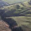
In a sheltered gully on the E flank of Dumyat there are six huts, a building, a head-dyke, extensive rig and a series of small fields of at least two phases. The huts and building are scattered across the field-system.
(MENS97 69-72, 163-5)
Visited by RCAHMS (DCC, JBS) 20 May 1997

