|
Photographs and Off-line Digital Images |
ST 9123 |
RCAHMS Aerial Photography |
Oblique aerial view. |
1982 |
Item Level |
|
|
Photographs and Off-line Digital Images |
ST 9124 |
RCAHMS Aerial Photography |
Oblique aerial view. |
1982 |
Item Level |
|
|
Photographs and Off-line Digital Images |
ST 9125 |
RCAHMS Aerial Photography |
Oblique aerial view. |
1982 |
Item Level |
|
|
Photographs and Off-line Digital Images |
ST 9126 |
RCAHMS Aerial Photography |
Oblique aerial view. |
1982 |
Item Level |
|
|
Photographs and Off-line Digital Images |
ST 9127 |
RCAHMS Aerial Photography |
Oblique aerial view. |
1982 |
Item Level |
|
|
Photographs and Off-line Digital Images |
ST 9128 |
RCAHMS Aerial Photography |
Oblique aerial view. |
1982 |
Item Level |
|
|
Manuscripts |
MS 731/19 |
Records of the Royal Commission on the Ancient and Historical Monuments of Scotland (RCAHMS), Edinbu |
Afforestable Land Survey field database (Menstrie Glen survey, 1997). Held as attribute table in GIS and in Oracle Field/AP table. Please see DX001444 |
1997 |
Item Level |
|
|
Photographs and Off-line Digital Images |
D 59301 |
Records of the Royal Commission on the Ancient and Historical Monuments of Scotland (RCAHMS), Edinbu |
View of farmstead from west. |
1998 |
Item Level |
|
|
Photographs and Off-line Digital Images |
D 59302 CN |
Records of the Royal Commission on the Ancient and Historical Monuments of Scotland (RCAHMS), Edinbu |
View of farmstead from west. |
1998 |
Item Level |
|
|
Photographs and Off-line Digital Images |
D 59281 |
Records of the Royal Commission on the Ancient and Historical Monuments of Scotland (RCAHMS), Edinbu |
General view of Menstrie Glen from Backside of Lipney looking north-west across the glen. |
1998 |
Item Level |
|
|
Photographs and Off-line Digital Images |
D 59282 CN |
Records of the Royal Commission on the Ancient and Historical Monuments of Scotland (RCAHMS), Edinbu |
General view of Menstrie Glen from Backside of Lipney looking north-west across the glen. |
1998 |
Item Level |
|
|
Photographs and Off-line Digital Images |
D 59284 CN |
Records of the Royal Commission on the Ancient and Historical Monuments of Scotland (RCAHMS), Edinbu |
General view of Menstrie Glen from Backside of Lipney looking north-west across the glen. |
1998 |
Item Level |
|
|
Photographs and Off-line Digital Images |
D 59283 |
Records of the Royal Commission on the Ancient and Historical Monuments of Scotland (RCAHMS), Edinbu |
General view of Menstrie Glen from Backside of Lipney looking north-west across the glen. |
1998 |
Item Level |
|
|
Photographs and Off-line Digital Images |
D 59285 CN |
Records of the Royal Commission on the Ancient and Historical Monuments of Scotland (RCAHMS), Edinbu |
General view of Menstrie Glen from Ashentrool (NS89NW 56.00) looking south-east. |
1998 |
Item Level |
|
|
Photographs and Off-line Digital Images |
D 28116 |
RCAHMS Aerial Photography |
Oblique aerial view of Backside of Lipney centred on an archaeological landscape, taken from the NNE. |
20/1/1998 |
Item Level |
|
 |
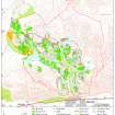
On-line Digital Images |
SC 1346654 |
Records of the Royal Commission on the Ancient and Historical Monuments of Scotland (RCAHMS), Edinbu |
Map showing distribution of settlements in Menstrie Glen before the 1760s with head-dykes and cultivated ground. Fig 11 in "Well shelterd & watered" Menstrie Glen, a farming landscape near Stirling. |
2001 |
Item Level |
|
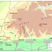 |
On-line Digital Images |
SC 1346655 |
Records of the Royal Commission on the Ancient and Historical Monuments of Scotland (RCAHMS), Edinbu |
Map of the western end of the Ochils showing the location of Menstrie Glen. Fig 12 in "Well shelterd & watered" Menstrie Glen, a farming landscape near Stirling. |
2001 |
Item Level |
|
 |
On-line Digital Images |
SC 1346666 |
Records of the Royal Commission on the Ancient and Historical Monuments of Scotland (RCAHMS), Edinbu |
Illustration showing layout of farmsteads in the Menstrie Glen. Fig 31 in "Well shelterd & watered" Menstrie Glen, a farming landscape near Stirling. |
|
Item Level |
|
 |
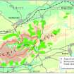
On-line Digital Images |
SC 1346675 |
Records of the Royal Commission on the Ancient and Historical Monuments of Scotland (RCAHMS), Edinbu |
Map showing the extents of different types of rig in Menstrie Glen. Fig 48 in "Well shelterd & watered" Menstrie Glen, a farming landscape near Stirling. |
|
Item Level |
|
 |
On-line Digital Images |
SC 1346677 |
Records of the Royal Commission on the Ancient and Historical Monuments of Scotland (RCAHMS), Edinbu |
Extent of relict cultivation in the Ochil Hills. Fig 57 in "Well shelterd & watered" Menstrie Glen, a farming landscape near Stirling. |
|
Item Level |
|
|
Digital Files (Non-image) |
GV 005173 |
Records of the Royal Commission on the Ancient and Historical Monuments of Scotland (RCAHMS), Edinbu |
Adobe Illustrator map of the western end of the Ochils showing the location of Menstrie Glen. Fig 12 in "Well shelterd & watered" Menstrie Glen, a farming landscape near Stirling.showing property names in Menstrie Glen. Fig 12 in "Well shelterd & watered" Menstrie Glen, a farming landscape near Stirling. |
2001 |
Item Level |
|
|
Digital Files (Non-image) |
GV 005174 |
Records of the Royal Commission on the Ancient and Historical Monuments of Scotland (RCAHMS), Edinbu |
Adobe Illustrator map depicting arable land and settlement. Fig 21 in "Well shelterd & watered" Menstrie Glen, a farming landscape near Stirling.showing property names in Menstrie Glen. Fig 12 in "Well shelterd & watered" Menstrie Glen, a farming landscape near Stirling. |
2001 |
Item Level |
|
|
Digital Files (Non-image) |
GV 005175 |
Records of the Royal Commission on the Ancient and Historical Monuments of Scotland (RCAHMS), Edinbu |
Adobe Illustrator map showing distribution of settlements in Menstrie Glen before the 1760s. Fig 23 in "Well shelterd & watered" Menstrie Glen, a farming landscape near Stirling.showing property names in Menstrie Glen. Fig 12 in "Well shelterd & watered" Menstrie Glen, a farming landscape near Stirling. |
2001 |
Item Level |
|
|
Digital Files (Non-image) |
GV 005179 |
Records of the Royal Commission on the Ancient and Historical Monuments of Scotland (RCAHMS), Edinbu |
Adobe Illustrator plans showing the range of layouts of farmsteads within Menstrie Glen. Fig 31 in "Well shelterd & watered" Menstrie Glen, a farming landscape near Stirling. |
2001 |
Item Level |
|


