
Invergordon, Ramped Ferry Pier


Pier (Period Unassigned)
Site Name Invergordon, Ramped Ferry Pier
Classification Pier (Period Unassigned)
Alternative Name(s) Firth Of Cromarty; Cromarty Firth
Canmore ID 14501
Site Number NH76NW 23
NGR NH 70731 68268
Datum OSGB36 - NGR
Permalink http://canmore.org.uk/site/14501


- Council Highland
- Parish Rosskeen
- Former Region Highland
- Former District Ross And Cromarty
- Former County Ross And Cromarty
NH76NW 23 71007 68420
Slipway [NAT]
OS (GIS) MasterMap, June 2009.
Location formerly entered as NH 7101 6841.
For (associated) pier at Inverbreakie (NH 70240 67150), see NH76NW 18.
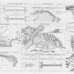
[No location specified]. To the East [of the harbour NH76NW 21] is a ramped ferry pier, built 1817 [by] engineer Thomas Telford, used by the ferry to Inverbreakie on the Black Isle.
J R Hume 1977
In daily use, stable condition.
CFA/MORA Coastal Assessment Survey 1998.
Note (7 January 2016)
NGR corrected to NH 70731 68268.
Previous NGR refers to a slipway which was wrongly identified as the ferry pier (see NH76NW 153).
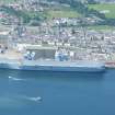
The ferry pier was located to the west of the harbour (NH76NW 21) as depicted on the OS 1st and 2nd edition 6-inch map (Ross-shire 1880, sheet LXVI and 1907, sheet LXVI). Expansion of the port has resulted land reclaimation in the area of the former pier and it is no longer visible.
Information from Historic Environment Scotland (AKK) 7 January 2016.

