
Loss Hill


Byre Dwelling (Post Medieval)(Possible), Field Boundary (Medieval) - (Post Medieval), Shieling Hut(S) (Medieval) - (Post Medieval)
Site Name Loss Hill
Classification Byre Dwelling (Post Medieval)(Possible), Field Boundary (Medieval) - (Post Medieval), Shieling Hut(S) (Medieval) - (Post Medieval)
Alternative Name(s) Ashentrool
Canmore ID 145007
Site Number NS89NW 56.05
NGR NS 8304 9986
Datum OSGB36 - NGR
Permalink http://canmore.org.uk/site/145007


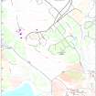

- Council Stirling
- Parish Logie (Stirling)
- Former Region Central
- Former District Stirling
- Former County Stirlingshire
Field Visit (5 May 1997)
NS89NW 56.05 8304 9986
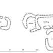
The footings of four subrectangular, turf-walled shieling-huts are situated on a grassy terrace on the WSW flank of Loss Hill. The structures are joined to form two pairs of inter-related buildings, with the implication of some phasing in construction, although the exact nature of this is not clear due to the turf construction and tussocky grass which covers the site. The northern pair of structures (MENS97 86, 87) lie at right-angles to each other, forming a rough L-shape, the northern element of which (MENS97 86) appears to be the earlier. This hut measures 6.6m from ENE to WSW by 2.4m internally with an entrance in the WSW end. A bulge in the thickness of the NNW wall may be due to its collapse. It is overlain on the SSE by the second hut (MENS97 87) which measures 4.5m by 2.8m internally. The entrance is on the WSW side, with two later gaps in the ENE.
The S pair of structures (MENS97 168, 169) exhibit more complexity, comprising a building with an annexe, and a hut. The building (MENS97 168) measures 10.2m from NNW to SSE by 3.4m internally, with an entrance in the NNW end of the WSW side. There is a break of slope across the interior and the SSE half of the interior is dished, suggesting a byre, for which there may have been an outlet through the SSE end of the WSW side, into a shallow hollow. Also on the WSW side there is an indentation in the line of the inner face of the bank, perhaps the position of a blocked entrance. A C-shaped outshot extends for 4.8m to the NE, with its own entrance on the W. Abutting the WSW side of the building there is a hut (MENS97 169) which may block the possible entrance. The hut lies at right-angles to the building and measures 5.8m from ENE to WSW by 3.4m transversely, with an entrance in the NNW side. Turf-stripping halos are visible along the ENE and SSE sides of the structures.
A turf bank runs along the leading edge of the terrace to the W of the huts and may have formed an enclosure measuring about 80m from N to S by at least 60m transversely, the W side of which is disrupted by spoil from a copper mine (NS 89 NW 56.06).
(MENS97 86-7, 168-9)
Visited by RCAHMS (DCC) 5 May 1997

