
Second Inchna Burn


Farmstead (Post Medieval)
Site Name Second Inchna Burn
Classification Farmstead (Post Medieval)
Alternative Name(s) Inchney
Canmore ID 144312
Site Number NS89NE 56.01
NGR NS 84982 98619
NGR Description NS 84982 98619 and NS 85012 98583
Datum OSGB36 - NGR
Permalink http://canmore.org.uk/site/144312


- Council Clackmannan
- Parish Alva
- Former Region Central
- Former District Clackmannan
- Former County Clackmannanshire
Field Visit (August 1977)
Menstrie Glen NS 849 985 NS89NW
Traces of a turf structure beneath a modern sheepfold probably represent an earlier enclosure.
RCAHMS 1978, visited August 1977
Field Visit (24 April 1997)
NS89NE 56.01 8500 9859
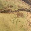
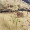
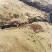
This farmstead lies across several terraces on the spur between the First and Second Inchna Burns in the midst of extensive unenclosed rig cultivation. The field-system on the hillside above and along the SE side of the Second Inchna Burn exhibits several phases in its layout. A rectangular drystone walled sheepfold overlies the core of the farmstead and may have destroyed other structures.
The largest building (MENS97 26) lies partly under the NE side of the sheepfold. It measures 16.7m by 3.3m within an extensively robbed stony bank and has been divided into three compartments. There are three conjoined earthen-banked enclosures to the S and W of the building, also partially overlain by the sheepfold (formerly described under NS 89 NW 44). On a terrace to the ESE there is a hut (MENS97 23) measuring 5.4m by 3.4m internally, on the SW side of a rectangular enclosure. The footings of what may have been two further buildings (MENS97 24, 25) have been reduced to little more than a ragged stony bank, each measuring about 7.2m by 3.5m internally. Two further stone and earth banked enclosures lie to the NE (NS 8498 9862) and SE (NS 8503 9856) of the buildings.
(MENS97 23-6)
Visited by RCAHMS (DCC) 24 April 1997

