
Dunachton Mill


Farmstead (Period Unassigned), Rig And Furrow (Medieval) - (Post Medieval), Township (Period Unassigned)
Site Name Dunachton Mill
Classification Farmstead (Period Unassigned), Rig And Furrow (Medieval) - (Post Medieval), Township (Period Unassigned)
Canmore ID 144185
Site Number NH80NW 45
NGR NH 818 052
Datum OSGB36 - NGR
Permalink http://canmore.org.uk/site/144185


- Council Highland
- Parish Alvie
- Former Region Highland
- Former District Badenoch And Strathspey
- Former County Inverness-shire
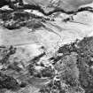
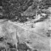
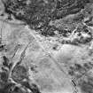
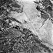
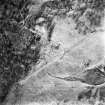
NH80NW 45 818 052.
Aerial photography (RCAHMSAP 1995) has revealed the remains of a farmstead, township, rig and field banks at the foot of a hillside 450m WNW of Dunachton Mill. At least five unroofed buildings, and a possible kiln, are visible on the W side of a trackway. These buildings are not depicted on the 1st edition of the OS 6-inch map (Inverness-shire 1872, sheets lxxxvii) or the current edition of the OS 1:10000 map (1995), although one field bank is. A patch of rig and furrow cultivation lies immediately to the E of the buildings and the trackway.
Information from RCAHMS (KB) 30 April 1999

