|
Photographs and Off-line Digital Images |
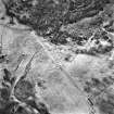
C 41460 |
RCAHMS Aerial Photography |
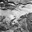
Dunachton Burn and Mill, oblique aerial view, taken fom the NW, centred on the remains of a small township, an area of rig, and traces of an unenclosed settlement beside the burn. The remains of Dunachton Burn mill are visible in the top right-hand corner of the photograph. |
9/2/1995 |
Item Level |
|
|
Photographs and Off-line Digital Images |
C 41461 |
RCAHMS Aerial Photography |
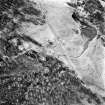
Dunachton Burn and Mill, oblique aerial view, taken fom the WSW, centred on the remains of a small township, an area of rig, and traces of an unenclosed settlement beside the burn. |
9/2/1995 |
Item Level |
|
|
Photographs and Off-line Digital Images |
C 41462 |
RCAHMS Aerial Photography |
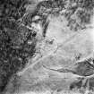
Dunachton Burn and Mill, oblique aerial view, taken fom the S, centred on the remains of a small township, an area of rig, and traces of an unenclosed settlement beside the burn. |
9/2/1995 |
Item Level |
|
|
Photographs and Off-line Digital Images |
C 41463 |
RCAHMS Aerial Photography |
Dunachton Burn and Mill, oblique aerial view, taken fom the SE, centred on the remains of a small township, an area of rig, and traces of an unenclosed settlement beside the burn. The remains of Dunachton Burn mill are visible in the bottom left-hand corner of the photograph. |
9/2/1995 |
Item Level |
|
|
Photographs and Off-line Digital Images |
C 41464 |
RCAHMS Aerial Photography |
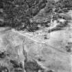
Dunachton Burn and Mill, oblique aerial view, taken fom the E, centred on the remains of a small township, an area of rig, and traces of an unenclosed settlement beside the burn. |
9/2/1995 |
Item Level |
|
 |
On-line Digital Images |
SC 1696283 |
RCAHMS Aerial Photography |
Dunachton Burn and Mill, oblique aerial view, taken fom the NW, centred on the remains of a small township, an area of rig, and traces of an unenclosed settlement beside the burn. The remains of Dunachton Burn mill are visible in the top right-hand corner of the photograph. |
9/2/1995 |
Item Level |
|
 |
On-line Digital Images |
SC 1696284 |
RCAHMS Aerial Photography |
Dunachton Burn and Mill, oblique aerial view, taken fom the WSW, centred on the remains of a small township, an area of rig, and traces of an unenclosed settlement beside the burn. |
9/2/1995 |
Item Level |
|
 |
On-line Digital Images |
SC 1696285 |
RCAHMS Aerial Photography |
Dunachton Burn and Mill, oblique aerial view, taken fom the S, centred on the remains of a small township, an area of rig, and traces of an unenclosed settlement beside the burn. |
9/2/1995 |
Item Level |
|
 |
On-line Digital Images |
SC 1696286 |
RCAHMS Aerial Photography |
Dunachton Burn and Mill, oblique aerial view, taken fom the SE, centred on the remains of a small township, an area of rig, and traces of an unenclosed settlement beside the burn. The remains of Dunachton Burn mill are visible in the bottom left-hand corner of the photograph. |
9/2/1995 |
Item Level |
|
 |
On-line Digital Images |
SC 1696287 |
RCAHMS Aerial Photography |
Dunachton Burn and Mill, oblique aerial view, taken fom the E, centred on the remains of a small township, an area of rig, and traces of an unenclosed settlement beside the burn. |
9/2/1995 |
Item Level |
|


