
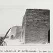
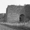
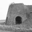
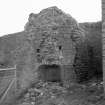
Edinburgh, Burdiehouse, Burdiehouse Road, Burdiehouse Limeworks


Lime Works (Period Unknown)
Site Name Edinburgh, Burdiehouse, Burdiehouse Road, Burdiehouse Limeworks
Classification Lime Works (Period Unknown)
Alternative Name(s) Lime Kilns; Lang Loan; Lasswade Road
Canmore ID 143935
Site Number NT26NE 96
NGR NT 27811 67264
Datum OSGB36 - NGR
Permalink http://canmore.org.uk/site/143935


- Council Edinburgh, City Of
- Parish Edinburgh (Edinburgh, City Of)
- Former Region Lothian
- Former District City Of Edinburgh
- Former County Midlothian
NT26NE 96 27811 67264
(Location cited as NT277 672) Burdiehouse Limestone Mine. Grampian Speleological Group note that this steeply dipping limestone was worked but was now flooded. The mine was sealed in the 1970s.
Grampian Speleological Group (2008).
NT26NE 96 27811 67264
Limekilns on the Lasswade Road.
NMRS:
large - 1 drawing (pencil) by A. Archer. 1834.
- Prints
Excavation (10 October 2012 - 24 October 2012)
A programme of archaeological trial trenching was carried out in order to satisfy a condition of the planning consent for the construction of residential development at Burdiehouse Mains, Edinburgh (Plan. Ref. 10/01185/PPP). A Desk Based Assessment relating to the development has been undertaken in connection with the planning application (Headland Archaeology Ltd Archive Report 2010 Burdiehouse, Edinburgh- Archaeological Desk-Based Assessment). The evaluation covered the area of the proposed development extending over three fields bounded to the south by the Edinburgh Bypass and to the west by Burdiehouse Road. The trial trenching comprised 53 trenches totalling 7310m2. These trenches revealed multiple ceramic and rubble field drains of recent date across the development area, sealed beneath topsoil on average 0.5m deep. A brick and concrete platform or surface of modern date was uncovered in the far eastern section of the site and led to a second phase of excavation in which an area approximately 20m2 was fully uncovered and lime stone walls relating to a possible 19th century farm building were recorded.
Information from Matthew Ginnever (Headland Archaeology) January 2013. OASIS ID:headland1-136419

