|
Manuscripts |
MS 1007/6 |
Mairi Logie |
Fort Augustus to Bernera Barracks. An assessment of the 18th century military roads which lie within the Highland Council boundaries. |
1997 |
Item Level |
|
 |
On-line Digital Images |
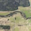
DP 111918 |
RCAHMS Aerial Photography Digital |
Oblique aerial view of the remains of the Fort Augustus-Bernera military road along Strath Cluanie and the proposed site for Allt An Eoin windfarm, taken from the SSE. |
1/5/2011 |
Item Level |
|
 |
On-line Digital Images |
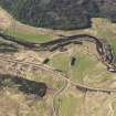
DP 111919 |
RCAHMS Aerial Photography Digital |
Oblique aerial view of the remains of the Fort Augustus-Bernera military road along Strath Cluanie and the proposed site for Allt An Eoin windfarm, taken from the SE. |
1/5/2011 |
Item Level |
|
|
All Other |
551 166/1/1 |
Records of the Ordnance Survey, Southampton, Hampshire, England |
Archaeological site card index ('495' cards) |
1947 |
Sub-Group Level |
|


