
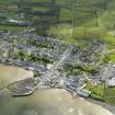
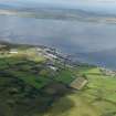
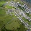
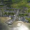
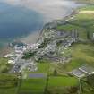
Islay, Bowmore, Pier


Pier (Period Unassigned)
Site Name Islay, Bowmore, Pier
Classification Pier (Period Unassigned)
Alternative Name(s) Main Street; High Street; Loch Indaal
Canmore ID 142594
Site Number NR35NW 43
NGR NR 3103 5998
Datum OSGB36 - NGR
Permalink http://canmore.org.uk/site/142594


- Council Argyll And Bute
- Parish Killarow And Kilmeny
- Former Region Strathclyde
- Former District Argyll And Bute
- Former County Argyll
NR35NW 43 3103 5998.
For Flying Boat Base see NR35NW 60.00
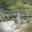
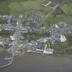
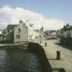
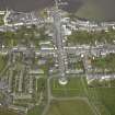
The first pier was built in 1750 by order of the Islay Stent Committee. The stonework of the orginal pier, some of which is still visible, had a wooden staging added in the late 1800s.
In 1940 the RAF began work altering the pier to provide safe shelter for the launches used to service Sunderland flying boats based on Loch Indaal (NR35NW 60.00). The work involved sheet piling along the inner face and an increase in height using pre-cast concrete blocks. The length of the pier was considerably increased, and using Dutch engineers, a massive stone breakwater was also constructed to the E projecting beyond the pierhead to provide protection to the harbour basin. In addition, a limited amount of dredging was carried out to maintain the minimum depth of 2.5m for the launches, fuel tamkers and other shipping using the pier. At the end of the war the dredging ceased and subsequently the harbour has begun to silt up.
Today, due to the lack of adequate foundations there are problems with the pier extension and repairs are now constantly needed.
Information from Ileach, Vol 25, 1998 (Bowmore Harbour Association).

