
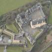
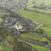
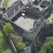
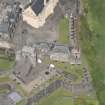
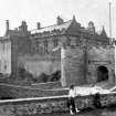
Stirling Castle, Palace


Palace (16th Century)
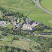
Site Name Stirling Castle, Palace
Classification Palace (16th Century)
Alternative Name(s) Palace Of James V
Canmore ID 142457
Site Number NS79SE 6.01
NGR NS 78996 94035
Datum OSGB36 - NGR
Permalink http://canmore.org.uk/site/142457


First 100 images shown. See the Collections panel (below) for a link to all digital images.
- Council Stirling
- Parish Stirling
- Former Region Central
- Former District Stirling
- Former County Stirlingshire
NS79SE 6.01 78996 94035
NS 7899 9403 In advance of extensive alteration and renovation at James V's Palace, detailed archival research and standing building recording were undertaken both within the Palace and in the adjacent Governor's Kitchen.
This project began with research into archival material relating directly to building work. The rich archive of Historic Scotland is being catalogued and scanned electronically. A baseline standing building recording exercise was completed prior to any intrusive works.
A small excavation was carried out outside the West Range in the raised grassed area against the S external wall of the Governor's Kitchen. A further excavation was completed at the base of the exterior W face of the Palace block. These two trenches showed evidence of residual structures apparently pre-dating the present Palace layout. It is thought that part of the West Range of the Palace (c 1538) collapsed during the later 16th century, and therefore it is possible that some of the structural remains identified in the excavations relate to this part of the Palace. However, survey work in the S and W sides of the Palace interior suggests that the Palace building programme after 1538 saw the recycling of several extant buildings. The forework of James IV and the Prince's Tower were effectively integrated with the Palace fabric on its S side, and it now seems likely that buildings to the W and E were incorporated within the eventual Palace design.
The relationship between the Palace and the early chapel identified beneath the Governor's Kitchen (DES 1998, 95-6) is still unclear, but it seems likely that the chapel was truncated when the Palace N and W ranges were constructed. Ongoing work includes a detailed survey of all floor joists in advance of dendrochronological analysis, and to identify evidence of how ceilings and floors were attached in the earliest Palace phase. There was considerable rebuilding and modification to the mid-16th-century Palace throughout the 17th century, and a full record of these changes is being compiled.
Archive to be deposited in the NMRS.
Sponsor: HS
G Ewart 2003
NS 789 940 In advance of an extensive programme of refurbishment within the Palace block in the castle, the entire complex was subject to a series of detailed archaeological analyses, including test trenching in the vaults below the W Range, S Range and E Range, as part of the broad programme of excavation on the Ladies Lookout (see DES 2003, 128).
The results of the fieldwork, both from the upstanding building analysis and the excavations, has demonstrated how much of the Palace of James V derived from an existing layout featuring complex ranges and courtyards. At this interim stage, the evidence suggests that the 1540s work saw the encapsulation of versions of a S Range, W Range and E Range within the James V quadrangular plan, which in turn recycled a courtyard area as the focus for the new plan, the Lion's Den.
All the earlier ranges were themselves complex developments of originally separate buildings, which were extended and merged during the reign of James IV. Both the E and W Ranges survived, in part at least, to second floor level within the new work. On the S side, the new work was built over the old S Range (which lost its upper floor(s) at this time), and met the extended face of the James IV Forework. The remaining gap between the early S Range and Forework was vaulted over to form the S Transe of the James V layout.
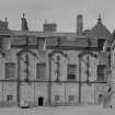
Outside the new quadrangle, the old chapel of St Michael, the Princes Tower and probably a kitchen were retained within the new layout as discrete specialised ancillary structures, augmenting the various formal, private and service functions of the four new ranges on three floors.
Some of the sequence of building and conversion which followed the 1540s building programme has also been revealed more clearly. This includes the wholesale remodelling of the W Range in the 1580s and conversions to the upper floor during the early 17th century, all on behalf of James VI. During the late 17th century, the Earl of Mar carried on the sub-division of the upper floor, raised the roof line and constructed a new stair from the Upper Square to the upper floor.
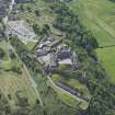
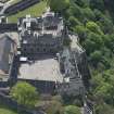
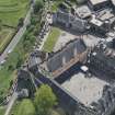
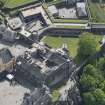
A phased programme of archaeological excavation was completed on the Ladies Lookout between April and December 2004.
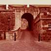
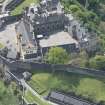
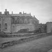
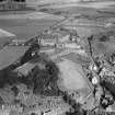
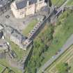
The site lies W of the Palace block and S of the Governor's Kitchen, and presently comprises a two-gun battery along the outer curtain wall of the castle. The gun platforms and associated paved surface occupy a terrace lying up to 2m below two sloping grassed areas immediately adjacent to the W Range of the Palace and Governor's Kitchen.
Overall, the Ladies Lookout reflects two natural bedrock terraces, the lower of which is presently occupied by the gun platforms and the upper by the grassed areas. The following main periods of use and abandonment for the Palace were observed.
Period 1: 1480-1510. The natural bedrock terracing has dictated the scale and orientation of the outer walls at the SW corner of the inner castle defensive enclosure. The Palace, as built by 1542, lay within a wall line built from the break in slope between the two natural terraces. The resulting wall ran diagonally across the site and retained buildings at its southern and northern ends. At this stage these are identified as a probable kitchen block to the N, and the W end of a range of buildings at the S end. Both these structures are provisionally dated to the reign of James IV, and are associated with royal accommodation towards the SW corner of the castle enclosure, within the new Forework and S of the Upper Square.
Period 2: 1540-42. During the reign of James V, parts of the earlier layout were converted to form the W and S ranges of a new palace. In the Ladies Lookout this work included the probable kitchen, and saw the retention of the diagonal outer wall as the limit for the major buildings in this part of the site. However, a new outer wall with a distinctive curving alignment was built further to the W. It exploited the limits of the lowest natural rock terrace but appears to have been a revetting structure, and so most likely represents the extension of the available potential building/occupation area beyond the Period 2 limits of the site. It is not clear what function this new extension fulfilled, but it is likely that the retaining wall itself was much higher.
Period 3: 1585-1625. The W Range of the Palace was rebuilt and parts of both the kitchen and S Range were cleared away. This work was intended to upgrade the W Range for James VI in the 1580s, and also to rationalise the Palace plan after serious structural collapse, documented to the first quarter of the 17th century. The latter most likely refers to the outer rampart which was clearly reduced in height in Period 4.
Period 4: 1708-50. The need to create a wide gun battery at the SW corner of a redrafted defensive line saw the abandonment of the Period 1 diagonal wall line in favour of an irregular trace extending the earlier enclosure northwards. A new wall was constructed over the truncated Period 3 wall, to retain a massive dump of debris and soil, up to 7m deep, which formed the new artillery earthwork during the early 18th century. This battery featured two large gun platforms - one to the N and the other looking S. Elsewhere, a large ablution block was constructed against the face of the Period 3 Palace W Range.
Period 5: 1850-1900. The outer wall line was raised by some 3m and the gun platforms were reinforced. In addition, the ablution block was extended and new lavatories were built on the W rampart.
Archive to be deposited in the NMRS.
Sponsor: HS.
G Ewart and D Murray 2004
Kirkdale Archaeology carried out a series of excavations in the western areas of Stirling Castle, centred around an area known as 'Ladies Lookout'. Deep deposits of dumped and naturally accumulated layers were uncovered, a selection of which were sent to CFA Archaeology for analysis. The layers were found to contain pottery fragments, glass, animal bone, cereal remains, plant material, wood charcoal, coal and cinders.
M Hastie 2006
Standing building recording; excavation NS 789 940 Ladies Lookout This extensive excavation, between October 2004 and August 2005, covered the southern half of the open terrace known as the Ladies Lookout and was the second phase of work (DES 2004, 129-30). This area lies at the extreme SW corner of the present castle circuit and immediately W of the W range of the mid-16thcentury Palace block of James V. It also lies immediately S of the
17th-century Governor's Kitchen, itself built over the 12th-century remains of the Chapel of St Michael.
The area presently comprises three separate terraces, the lowest of which accommodates at least two gun positions firing S and NW. The other two terraces are the landscaped remains of a variety of building and landscaping programmes, dating primarily from the later 15th century and culminating in major works during the 19th century. These upper terraces were to a large extent excavated in the Ladies Lookout first phase of work, and revealed traces of a
kitchen immediately S of the present Governor's Kitchen to the N of the site. On its E side, evidence was found of the footings of what is probably an incomplete external stair of early 18th-century date, and the sequence of buildings known as the Ablution House, which was only demolished in the later 20th century. Beneath the latter, fragmentary traces of buildings of apparent 13th-and 14th-century date were also identified.
The most recent programme of work concentrated on the lower terrace, and was intended to shed light on the changes in the outer rampart line as well as add to the ongoing interpretation of the exceedingly complicated W gallery phasing. Removal of the later gun platforms revealed earlier/18th-century versions similarly placed, albeit within a possibly earthwork parapet. These in turn were laid over a colossal earthwork, which extended the effective limits of the site to its present alignment out over the steeply terraced bedrock of the castle rock at this point. However, below this horizon
was a further earthwork of 16th-century date, the function of which is still unclear but which also projected the natural line of the castle defences out to the W. Evidence of a timber structure was also picked up in the form of post-holes respecting the natural limit of the site, but which appear to be of late medieval date at the earliest.
The synthesis of the results of the Ladies Lookout excavation phases 1 and 2 is ongoing, but appears to show that the natural/ pre-16th-century limits of the site are represented by a line roughly commensurate with the E terrace later to receive the Ablution House, etc.
An extensive finds assemblage, of primarily late and post-medieval date, includes coins, pottery, glass and metal artefacts.
Standing building recording within Palace Block
This programme of work carried on from the 2003-4 survey and excavation within the Palace block (DES 2004, 129-30), and was undertaken in advance of necessary remedial work on the fabric of the building.
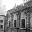
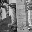
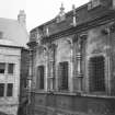
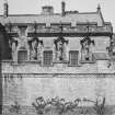
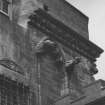
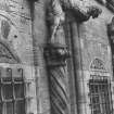
The upstanding building recording was concentrated primarily on the suite of rooms at the principal level. These comprise the royal apartments - with the King's chambers to the N of the quadrangle and the Queen's chamber on the S side. The E side contains the royal bedrooms, and the W comprises a gallery allowing access between the N and S ranges.
The main aim of the recording work was to form a comprehensive record of all significant elements within each chamber - doors, windows, fireplaces, etc., and also to retrieve any surviving details of the sequence of decorative schemes, partitions, and ceiling details, which have been removed in antiquity. The comprehensive repair and conversion programmes enacted on the royal apartments, in particular throughout the 18th and 19th centuries as they were converted to military use for the garrison, have removed much of the 16th-century details.
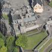
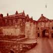
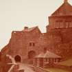
The quadrangular plan of the Palace, with occupation on two floors over a vaulted basement, dates from c 1542 and is the work of King James V. The new building was intended as accommodation for himself and his new queen, Mary of Guise. However, the results of the recent survey confirm that substantial elements of the present layout date from the reign of James IV and earlier. Essentially, the plan that James V devised was the integration of a series of buildings
grouped around a courtyard and within an outer rampart to create a regular plan following current European principles for a royal palace. It is now clear that the triple courtyard layout within Stirling Castle today is the result of a series of natural terraces in the bedrock, and they in turn have defined the limits of a series of enclosures over many centuries. The Palace of James V is built around the so-called Lion's Den, which was an open courtyard during the reign of James IV, defined by at least two separate structures on its E side: a range on two levels on its S side and a gallery-like range
on its W side. The 12th-century Chapel of St Michael defined at least part of this layout on the N side. These separate structures formed the basis for the Palace of James V, and one of the principal aims of the archaeological investigation was to identify residual and new build.
The removal of asbestos prompted monitoring work. All the rooms on the principal floor were affected, except the W range. Evidence of the sub-floor deposits and structures up to a depth of c 0.3m were recorded. The results showed how the latest floors of the principal apartments were constructed over dwarf walls, which featured recycled masonry from earlier paved surfaces. Artefacts retrieved include a child's shoe and a leather scabbard for a short sword or dirk-like weapon.
Archive to be deposited in NMRS.
Sponsor: HS.
G Ewart and D Murray 2005
NS79SE 6.01 78996 94035
NMRS REFERENCE
NMRS Printroom - Geoffrey Hay
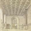
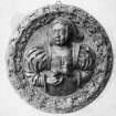
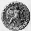
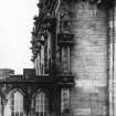
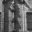
View of the King's Chamber, Stirling Palace, Stirling.
Conjectural reconstruction.
Unsigned, not dated, c.1975
Dyeline copy with wash applied
Notes: the drawing was used in 'The Stirling Heads', John Dunbar, 1975, while Hay was working for the RCAHMS
LORIMER COLLECTION
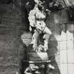
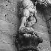
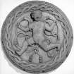
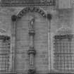
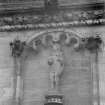
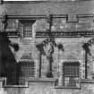
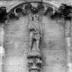
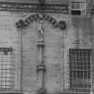
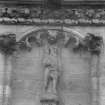
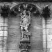
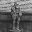
STIRLING CASTLE, THE PALACE OF JAMES 5TH
Tracings of drawings by J Gillespie and A Muir of the National Art Survey. The original drawings date to 1900 and are executed in pen and wash or pencil and watercolour wash; the tracings are in pencil. One of the tracings is signed 'Measured by Gillespie'.
Acquired by Lorimer via Rowand Anderson or whilst he was with the National Art Survey 1925 - 1930?
(The original drawings can be found in the Monuments Record: see STD/136/34 - 40)
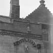
LOR/STIRLING CASTLE/1: 'Stirling Castle. Palace of James 5th. Half inch detail of North Elevation'. Elevation and section of north wall. Not signed and not dated
LOR/STIRLING CASTLE/2: 'Stirling Castle. The Palace of King James 5th'. East elevation. Not signed or dated
LOR/STIRLING CASTLE/3: 'Stirling Castle. The Palace of King James 5th Half Inch details of East elevation'. Not signed or dated.
LOR/STIRLING CASTLE/4: 'Stirling Castle. Palace of James 5th'. North elevation. Not signed or dated
LOR/STIRLING CASTLE/5: South elevation. Not signed or dated
LOR/STIRLING CASTLE/6: 'Quarter full size details of North elevation.
Signed: 'Measured by J Gillespie'
Dated: July 1900
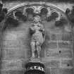
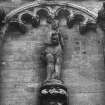
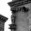
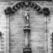
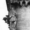
LOR/STIRLING CASTLE/7: 'Details 1/4 full size of figures etc. on South and East elevations of the Palace of James 5th. Sheet 2'. Not signed or dated.
Measured Survey (1866 - 1921)
The architect Sir Robert Rowand Anderson, founder of the Edinburgh School of Applied Art, initiated the National Art Survey of Scotland in 1866 to create a library depicting the best examples of Scottish Architecture from which students could take inspiration. Two bursars, selected from the best draughtsmen trained by the school were appointed each year. In 1903 the Edinburgh School of Applied Art joined with the Board of Manufacturer's School of Art to found the Edinburgh College of Art and the bursaries were continued there. The majority of the drawings were made by architectural students between 1895 and 1906.
The National Art Survey of Scotland Collection comprises around 1500 measured survey drawings by a number of different draughtsmen, many of whom later became well known architects, including Ramsay Traquair and Peter Macgregor. They cover a wide range of buildings from across Scotland including castles, tower houses, churches and urban structures, as well as decorative details, plasterwork and furniture.
Excavation (4 October 1993 - 29 October 1993)
A series of excavations were carried out by Kirkdale Archaeology in October 1993. Extensive excavations took place on the West side of the Great Hall, including the area of the Upper Square and Transe. These excavations reaveled evidence for an structure, possibly a Chapel.
Excavations were also carried out in advance of a services being laid in the area to the Northwest of the Casemates in the Queen Anne Garden.
G Ewart 1993
Sponsor: Historic Scotland
Kirkdale Archaeology
Excavation (19 December 1994 - 4 October 1995)
NS 7990 940 In advance of the re-roofing of the Chapel Royal, a programme of excavation was mounted over December and January of 1994-5 in the Upper Square and Douglas Gardens within the Castle.
The Upper Square: Two trenches were opened in the Upper Square. The earliest structure found was the SE corner of a stone building. This was formed by a SW-NE wall and its return, extending NW. The SW corner of the same building was seen in the 1994 excavation inside the Chapel Royal. This structure was aligned NE-SW. It measured c13.1m NE-SW and was at least 4m wide, although the northern limit was not seen.
A large amount of charcoal, ash and metalworking debris was recovered in the upper layers associated with the usage of this building, perhaps suggesting that the latest occupation was industrial. However, it may be that the building was originally an earlier version of the Castle Chapel, predating the 15th century Chapel.
The second phase of activity involved the construction of the 15th century Chapel, parts of which were also revealed throughout the trench, showing it to be at least 29m long and some 9m wide, aligned ENE-WSW.
The discovery of drystone structures within the levelling material prior to the construction of the 15th century Chapel suggest that it had two building phases, the first involving a crypt which was filled in at a later date to stabilise the masonry above, probably part of the documented 1505 repairs.
The other major structure studied in the Upper Square was the present Chapel Royal, known to date to 1594. A complete pottery vessel was found standing upright in the construction trench for the S wall of the Chapel. This pot was almost identical to vessels recovered from beneath the floor of Innerpeffray Church in Perthshire, these examples having been dated to the period 1508-1650.
There were at least eighteen different masons-marks noted on and around the string course of the S Chapel wall.
The Douglas Gardens: A total of six trenches were opened in the Douglas Gardens. The earliest remains comprised part of a wall aligned SE-NW, comparable to structures in the Upper Square, and finds recovered from this period of activity seemed to indicate an early-mid 14th century date for its demolition.
Built on top of this early wall was a retaining wall with a bank behind (to the W of) it. This revetment may have incorporated part of the earlier wall, which had by this stage been partially demolished. The bank seems to have stood to a height of c1.3m, and finds from its surface indicate late 15th-early 16th century activity.
G Ewart and A Radley 1995
Sponsor: Historic Scotland
Kirkdale Archaeology
NS 790 940 Fieldwork during summer 1995 concentrated mainly on excavation in the Upper Square, over and immediately adjacent to the late 18th-early 19th century cistern, which lies to the W of the Great Hall Transe. Further work comprised the monitoring of the excavation of a series of 11 small pits to receive information boards. One of these holes, located in the Queen Anne Gardens, revealed a lime-mortared wall, possibly that shown on the 17th century plan by Slezer. The remaining holes revealed little of archaeological significance, aside from levelling material.
The earliest features revealed in the main excavation comprised a series of occupation surfaces, truncated during the construction of the cistern. These deposits were only revealed in a narrow strip, on average 1m in width, but represent a complex series of early medieval occupation horizons. The medieval occupation is most obviously characterised by a hearth-site, which in turn probably relates to a series of crude structural timber settings, and floor surfaces. Overlying this sequence of deposits were tip-lines and courtyard levels associated with the construction, occupation and demolition of the 15th century Chapel Royal.
The Transe wall was built in two phases, the upper section relating to the vaulting-over of the Transe itself during the later 16th century.
The cistern was revealed in its entirety, showing it to be 15.5m long N-S by 4.25m wide, and of high quality sandstone construction. It had been much altered and repaired since its original construction, affecting both its supply and capacity, and access to it. The capacity of the tank was c120m3 (c26,400 gallons), and it was intended to provide water in the event of fire.
G Ewart and P Sharman 1995
Sponsor: Historic Scotland
Kirkdale Archaeology
NS 790 940 Excavation within the Great Hall comprised the recording of a series of cross-walls dating from the later 18th century conversion of the Hall to barrack accomodation. These walls sub-divided the ground floor into four chambers, with two staircases leading to upper floors. The walls themselves were of massive lime-mortar construction, and two of them featured flues serving fireplaces within the vaulted basement.
The Great Hall floor was recorded in detail, and evidence of both its original pattern and its subsequent damage to receive later floor surfaces and modifications to the internal arrangement of the Hall was noted. It appears that the pattern of floor slabs reflected some sub-divisions within the Hall as completed during the early years of the 16th century.
In addition, two trenches were excavated in advance of the re-roofing of the Great Hall. Of these trenches, one lay to the S of the Hall, and contained considerable deposits of charcoal, alongside pottery of 14th and 15th century type. The second trench was cut at the base of the E wall of the Palace. The excavation of this trench was curtailed by the presence of modern services.
G Ewart and A Radley 1995.
Sponsor: Historic Scotland
Kirkdale Archaeology
Excavation (5 September 1994 - 9 December 1994)
Ns 790 940 Excavation in the Chapel Royal and Lion's Den continued in the autumn of 1994 in advance of restoration and renovation. Work in the Lion's Den (the inner quadrangle of the 16th century Palace) revealed evidence of contemporary or later activities associated with the Palace. However, fragments of masonry were found in the extreme SE corner of the area, which relate to earlier 16th century buildings, but which were recycled for use in the present layout (built during the 1540s).
Elsewhere, a substantial retaining wall was found towards the S side of the Lion's Den, which appears to have defined the southern limits of the quadrangle layout. This in turn was probably formal and decorative, possibly some sort of parterre arrangement. The polygonal-shaped building discovered in previous excavations and located towards the middle of the area retained by the low S wall, along with a drain or sump lying towards the NE corner of the area, may have been integral to the formal layout. These were heavily altered and damaged by later occupancy of the Palace block. Certainly the polygonal building was used as a cistern serving 19th century lavatories.
In general the extent of damage to the 16th century layout was such as to have almost entirely removed most features and surfaces predating the extensive pipe laying and resurfacing activities of the 19th and 20th centuries.
In the Chapel Royal, the excavation begun in the summer of 1994 continued to bedrock, removing the remaining tips of debris which had been deposited as levelling for the floor of the Chapel Royal (built in 1594). This exercise resulted in a trench over 5m deep, the lower fills of which contained considerable amounts of firebrick and metal slag, apparently evidence of a demolished forge or foundry. Elsewhere within the Chapel Royal, traces of two earlier structures were found, one of which is assumed to be the late 15th century precursor to the 1594 chapel, and which in turn had truncated a smaller, as yet unidentified rectangular lime mortared stone building.
G Ewart and P Sharman 1995
Sponsor: Historic Scotland
Kirkdale Archaeology
Project (14 March 2003 - 22 June 2006)
SPARC: Stirling Castle Palace Archaeological and Historical Research
The Stirling Palace project was intended to extend existing research within an innovative and practical fieldwork and research framework. The results of this work were also intended to advance a new level of understanding of the sequence of building and alteration within the palace.
The investigation of the palace in particular sought to detail exactly how the complex was adapted to meet each new role over the centuries on a room-by-room, range-by-range and floor-by-floor basis. Excavation was targeted to show how alterations to the palace affected previous structures, either by inclusion within the new plan, truncation, or total destruction. The combined research then sought to place the site within its British and European context, and trace its transition from royal household to officer’s mess.
Information from Project website: http://sparc.scran.ac.uk/home/fieldwork/fieldwork.html?current=three
Work for SPARC was carried out from 2003 - 2006, with the majoirty of the work taking place between 2003 - 2005, and with a small phase of additional work in March 2007.
Watching Brief (19 January 2005 - 25 March 2005)
The archaeological monitoring of the asbestos removal in Stirling Castle Palace was a success. Evidence was found for the original flagstone floor and also changes to the floor type and level. It has also been possible to demonstrate that a timber floor existed in the Palace prior to the mid-19th century and to identify the 20th century changes at floor level.
Information from OASIS Id: kirkdale1-504407 (T Whalley) 2005
Standing Building Recording (13 March 2007 - 30 March 2007)
NS 789 940 As part of the ongoing programme of recording and investigation within the Palace at Stirling Castle (SPARC), newly exposed masonry on the Governors Stair was recorded between 13–30 March 2007. This showed how elements of the E wall of the Old Chapel were refaced as part of the creation of the new access route to the upper floor of the Palace (1708–14).
G Ewart 2007
Funder: Historic Scotland
Kirkdale Archaeology
Watching Brief (1 April 2008 - 29 September 2008)
NS 7899 9403 Various archaeological watching briefs were carried out between 1 April–29 September 2008 at Stirling Castle Palace before and during restoration works in 2008.
SCPP-2008-02 – Monitoring of slab removal prior to excavations between the Governor’s Kitchen and the King’s Old Buildings.
SCPP-2008-03 and SCPP-2008-06 – Monitoring of the excavation of a new drain along the base of the main W elevation of the palace (on the Ladies’ Lookout) – Most of this drain’s route was through backfill from the 2004 excavation of the Ladies’ Lookout. However, the S end of the drain revealed more of the foundations of the ragged angled wall at the SW corner of the Palace. OASIS Id: kirkdale1-504381
SCPP-2008-07 – Monitoring of the construction of new doorways in the Palace – The doorways were constructed between the King and Queen’s bedchambers and also between the Queen’s Inner and Outer Halls. Wall fabric and original door features revealed during restoration were recorded.
SCPP-2008-11: Inside the Palace the re-pointing of a relieving arch in the King’s closets was monitored and organic material sealed behind it was sampled. Also, the removal of plaster from the S end of the upper corridor of the West Range was monitored and recorded as it revealed roof fabric.
SCPP-2008-15: The removal of 20th-century service conduits from the King’s Inner Hall and the Queen’s Inner Hall was monitored and the residual plaster sealed behind was recorded.
Kirkdale Archaeology
Funder: Historic Scotland
Paul Fox, Sarah Hogg, David Murray and Alan Radley 2008
Excavation (17 April 2008 - 11 September 2008)
NS 7899 9403 Two excavations took place between the 17 April–11 September 2008 as part of the Stirling Castle Palace Project (SCPP) in advance of restoration works.
SCPP-2008-04 & SCPP-2008-12 – Excavation between the Governor’s Kitchen and the King’s Old Buildings – The area to the NW of the main Palace block comprised three discrete spaces, numbered from W to E during the main investigation into the Palace as P19, P20 and S07.
Early masonry made up the N and W walls of the ‘Governors Kitchen’, as well as the ‘corridor’ running around the W end of the building. This phase may be summarised as consisting of an E/W rectangular structure, with a corridor built around at least its W end. This is thought to be the castle chapel dating back to at least the 12th century, with the corridor providing access to the W end of this building, an arrangement perhaps necessitated by liturgical reasons.
These apertures were later blocked and a substantial amount of material introduced across much of the site.
Most of these layers are characterised by a concentration of charcoal, although a number of dumps of crushed sandstone indicate demolition or construction material. A relatively large amount of bone was recovered from these deposits, but few other finds. Although divided into numerous generally thin layers, much of this material probably came from the same sort of source, possibly from middens within the castle. A
variety of later structural remains and modern services were also uncovered.
SCPP-2008-10 – Excavation above the vault of the Princes Tower – Three small trenches were excavated in the first floor (above vault level) Prince’s Tower. Trench 1 was in the NE corner of the room, trench 2 the NW corner and trench 3 along the S wall of the room.
Structures were identified that possibly pre-date the vault of the Princes Tower. The structures were all seen at or below the current ground level. The height of the structure of which they formed part is not known. The suggestion is that it continued down to where there is now a vault. However they may have continued upwards and been demolished immediately before the construction of the existing building.
The top of the vault was only seen in small parts of both of the N trenches, where it was an uneven surface and would have sloped steeply to the E and W. Levelling deposits raised the ground level by up to 400mm at the E and W ends of the vault but petered out in the central part above the crown.
Above this was a clay deposit, possibly a floor surface, although there was no surviving evidence of anything being laid on the clay. An earlier fireplace was glimpsed behind and below the current one in the N wall and includes a structure up to 230mm below the current floor level, at roughly the same level as the clay ‘floor’.
The current floor is dated to the 19th–20th centuries and the dusty loose deposits below it yielded a single coin of possible 17th-century French origin.
Kirkdale Archaeology
Funder: Historic Scotland
Alan Radley 2008
Desk Based Assessment (1 January 2008)
Summary of the archival resources for Stirling Castle. This was a report produced as part of the work at Stirling Castle begun in the mid-2000s, which culminated in the publication of 'With Thy Towers High: The Archaeology of Stirling Castle and Palace' (Historic Scotland, Edinburgh, 2015).
Information from OASIS Id: kirkdale1-504406 (D Gallagher and J Harrison) 2008
Standing Building Recording (1 January 2008)
A report synthesising historical evidence with the findings of an exhaustive archaeological standing building survey completed in the palace. This was a report produced as part of the work at Stirling Castle begun in the mid-2000s, which culminated in the publication of 'With Thy Towers High: The Archaeology of Stirling Castle and Palace' (Historic Scotland, Edinburgh, 2015).
OASIS ID: kirkdale1-504439
Note (1 January 2008)
A discussion of the various aspects of the Scots royal court in the 16th Century. This was a report produced as part of the work at Stirling Castle begun in the mid-2000s, which culminated in the publication of 'With Thy Towers High: The Archaeology of Stirling Castle and Palace' (Historic Scotland, Edinburgh, 2015).
Information from OASIS ID: kirkdale1-504438 (J Harrison) 2008
Note (1 January 2008)
A detailed study of Marie de Guise at Stirling up to 1550, when she went to France, including the political, social and local context. This was a report produced as part of the work at Stirling Castle begun in the mid-2000s, which culminated in the publication of 'With Thy Towers High: The Archaeology of Stirling Castle and Palace' (Historic Scotland, Edinburgh, 2015).
Information from OASIS ID: kirkdale1-504437 (J Harrison) 2008
Note (1 January 2008)
Presentation of the wardrobe inventories of James V (particularly BL Royal 18C XIV F.184-215). This was a report produced as part of the work at Stirling Castle begun in the mid-2000s, which culminated in the publication of 'With Thy Towers High: The Archaeology of Stirling Castle and Palace' (Historic Scotland, Edinburgh, 2015).
Information from OASIS ID: kirkdale1-50443 (J Harrison) 2008
Artefact Analysis (1 January 2008)
Analysis of vessel glass fragments recovered during excavations at Stirling Castle. A formal archaeological analysis was made of the glass fragments. N.B. This was a report produced as part of the work at Stirling Castle begun in the mid-2000s, which culminated in the publication of 'With Thy Towers High: The Archaeology of Stirling Castle and Palace' (Historic Scotland, Edinburgh, 2015).
Information from OASIS ID: kirkdale1-504432 (D Gallagher) 2008
Standing Building Recording (1 January 2008)
Periodised descriptions of various interior and exterior elevations of the castle. This was a report produced as part of the work at Stirling Castle begun in the mid-2000s, which culminated in the publication of 'With Thy Towers High: The Archaeology of Stirling Castle and Palace' (Historic Scotland, Edinburgh, 2015).
Information from OASIS ID: kirkdale1-504435 (D Murray and S Hogg) 2008
Desk Based Assessment (1 January 2008)
A general discussion of the evidence produced as a result of the work at Stirling Castle begun in the mid-2000s, which culminated in the publication of 'With Thy Towers High: The Archaeology of Stirling Castle and Palace' (Historic Scotland, Edinburgh, 2015). A general discussion of the evidence produced as a result of the work at Stirling Castle begun in the mid-2000s, which culminated in the publication of 'With Thy Towers High: The Archaeology of Stirling Castle and Palace' (Historic Scotland, Edinburgh, 2015).
Information from OASIS ID: kirkdale1-504429 (G Ewart) 2008
Dendrochronology (1 January 2008)
Dendrochronological analysis of 133 oak timbers and 58 pine timbers from Stirling Castle. Six distinct episodes of building activity were identified. This was a report produced as part of the work at Stirling Castle begun in the mid-2000s, which culminated in the publication of 'With Thy Towers High: The Archaeology of Stirling Castle and Palace' (Historic Scotland, Edinburgh, 2015).
Information from OASIS ID: kirkdale1-504411 (A Crone) 2008
Standing Building Recording (1 January 2008)
The production of a basic categorisation of the various timbers of the floors and ceilings within the palace. This was a report produced as part of the work at Stirling Castle begun in the mid-2000s, which culminated in the publication of 'With Thy Towers High: The Archaeology of Stirling Castle and Palace' (Historic Scotland, Edinburgh, 2015).
Information from OASIS ID: kirkdale1-504424 (A Hollinrake and D Murray) 2008
Standing Building Recording (1 January 2008)
A commentary on the construction of the ceilings over the royal bedchambers. This was a report produced as part of the work at Stirling Castle begun in the mid-2000s, which culminated in the publication of 'With Thy Towers High: The Archaeology of Stirling Castle and Palace' (Historic Scotland, Edinburgh, 2015).
Information from OASIS ID: kirkdale1-504410 (T Hanke) 2008
Standing Building Recording (1 January 2008)
An examination of aspects of timber in post-renaissance Scotland, with a focus on Stirling Palace. This was a report produced as part of the work at Stirling Castle begun in the mid-2000s, which culminated in the publication of 'With Thy Towers High: The Archaeology of Stirling Castle and Palace' (Historic Scotland, Edinburgh, 2015).
Information from OASIS Id: kirkdale1-504408 (T Hanke) 2008
Artefact Analysis (25 June 2008)
Layers of paint were examined in rooms on the upper floor of the palace to shed light on the more recent development and use of the storey. This was a report produced by Michael Pearce (of Historic Scotland) as part of the work at Stirling Castle begun in the mid-2000s, which culminated in the publication of 'With Thy Towers High: The Archaeology of Stirling Castle and Palace' (Historic Scotland, Edinburgh, 2015).
Information from OASIS ID: kirkdale1-504427 (M Pearce) 2008
Standing Building Recording (5 March 2008 - 22 September 2008)
NS 7899 9403 As part of works in advance of the restoration works in the Palace various standing building surveys were completed between 5 March–22 September 2008. These surveys built upon and added to work undertaken between 2003 and 2007. The surveys were:
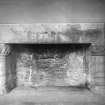
SCPP-2008-01 – Recording of fireplace hearths – Before restoration work began the hearthstones of the fireplaces in the principal rooms of the Palace were removed. These hearthstones were known to be early and mid-20th-century replacements. The opportunity was taken to record any surviving original fireplace features. It is apparent that the original fabrics of the 1540 hearths have been destroyed or seriously truncated over time with the main damage coming from the insertion of the large Caithness slabs in the 20th century. It seems that the original form of the fireplaces was a mortared platform of sandstone carrying the uprights, with a further platform internally onto which the flat sandstone hearth slabs could bed.
SCPP-2008-05 – Recording of a fallen sash window – In July 2008 one of the large sash windows in the S wall of the Queen’s Inner Hall collapsed into the Palace and suffered some damage. This gave the opportunity to record both the window and the surrounding aperture in detail. The window, previously assumed to be of possible 17th- or 18th-century date was shown to be an early 20th-century replacement with cast iron sash weights.
SCPP-2008-08 – Recording of recently stripped walls in the Princes Tower – The two remaining unstripped walls in the first floor of the Princes Tower were stripped of plaster in 2008. Before re-pointing these walls were recorded to the same standard as the recording in 2004 and 2005.
SCPP-2008-09 – Recording of the upper floor – The upper floor was originally surveyed as part of the 2003–2004 works. In 2008 the opportunity arose to revisit this work and to complete a full photographic survey of the rooms before restoration. Various interventions into the wall fabrics since 2004 were also recorded.
SCPP-2008-13 – Recording of the Governor’s Kitchen – Recording of the fabric of the interior walls of the Governor’s kitchen was undertaken following stripping of plaster from some of the walls. The walls were drawn by hand, added to existing elevations drawn during the 1997 (SCAK97) excavation in the rooms, and the features described. Evidence for changes in wall fabric was noted including original builds and crude 19th- and 20th-century repairs.
Kirkdale Archaeology
Funder: Historic Scotland
Paul Fox, Sarah Hogg, David Murray and Tom Whalley 2008
OASIS ID: kirkdale1-60239
Project (3 March 2008 - 9 December 2009)
SCPP: Stirling Castle Palace Project
A variety of archaeological work was carried out between 2008 and 2009 by Kirkdale Archaeology under the framework of the Stirling Castle Palace project. This included work on the Palace, Kings Old Buildings, Govenor's Kitchen, Princes Tower, and Douglas Gardens and involved excavations, watching briefs, and standing building recordings.
Watching Brief (23 October 2008 - 30 September 2009)
NS 789 940 Various watching briefs have been carried out between 23 October 2008–30 September 2009 during restoration works. These consisted of:
• Excavation in advance of new service pipes in the Douglas Gardens. This revealed evidence of landscaping works during the construction of the Chapel Royal in 1594.
• Recording and monitoring in advance of alterations to the Palace:
• Re-opening of a 17th-century door in the N corridor.
• Installation of service ducts in the attic space.
• Removal of a ceiling beam in the mezzanine level of the Prince’s Tower.
• Access to a possible garderobe shaft in the W wall of the West Range.
• Monitoring of new joist pocket installation throughout the principal floor of the Palace.
• Detailed records of elevations associated with the Governor’s kitchen (internal and external).
• Monitoring of service duct installation in the King’s Old Building and leading towards the Old Chapel.
• Standing building recording of the SE corner of the Upper Floor. This completed the drawn record of the Upper
Floor in line with the survey to date.
Also, during work on the Upper Floor of the East Range of the Palace several crudely carved 19th-century toy soldiers and horses were retrieved by contractors.
Kirkdale Archaeology
Funder: Historic Scotland
Gordon Ewart 2009
Excavation (22 April 2009)
While the actual excavation of these three holes through the fabric of the Palace revealed little new information, the opportunity to examine these walls in detail proved very informative.
The most interesting thing about the S wall was the disposition of the two plasters A:03.3.002 and 003. A:03.3.002 seemed to represent an undercoat over which smooth finished plaster A:04.3.003 had been applied. The well defined upper limit, some 1.15 m above the current floor level, showed that the upper part of the wall was not expected to be visible, indicating that this space was not expected to have a formal use. The sloping edges to these renders, below and at a shallower angle to the current roof line, indicated that they pre-dated this arrangement. Evidence from elsewhere in the Palace (especially from the Lion’s Den, where the walls all seemed to have been slightly raised) indicated a reroofing exercise in the late-seventeenth century. There seems little reason to doubt that these plasters date to the mid-sixteenth century construction of the Palace. The small patch of dark grey mortar, A:04.3.004 is probably indicative of a repair.
The information obtained from the N wall was more complex. The evidence for two discrete wall faces, with the upper (A:04.1.001) running behind the lower (A:04.1.002), was intriguing, and obviously not matched in the S wall. While this could reflect an eccentricity of construction, this NE corner of the Palace has always offered tantalising hints of the re-use of earlier buildings. This is clearest at vault level, where room V:02 has long been suggested to be part of an older building, the E wall of which was rebuilt when the Palace was constructed. On the Principal Level the evidence of the King’s Bed Chamber (P: 04), above V:02 is harder to interpret, but it has been suggested that at least parts of the N and W wall were recycled when the Palace was built. The observations made in A:04 may indicate that fragments of older masonry survive all the way to the Attic level. The only problem with this is that the sequence here seems to be reversed, with the wall to the N (A:04.1.001) apparently pre-dating that to the S (A: 04.1.002). It should also be noted that the E range runs at a different angle to the rest of the Palace, which means that the N wall of the E range, where it connects to the N range, had to maintain a strange ‘wedge’ shape to reconcile these different orientations.
Information from OASIS Id: kirkdale1-504413 (d Murray) 2009
Watching Brief (10 March 2009 - 11 March 2009)
Kirkdale Archaeology was asked to undertake an archaeological watching brief in Stirling Castle while a floor was prepared to receive a new concrete base. The room is the westernmost on the S side of the transe running below James V’s Palace. The Vaults & Palace lie to the N, the Prince’s Tower to the E & there is an enclosing wall on both the N & W sides of this open-air space. Most recently, the space was used to house electricity & paint stores- these were of 20th Century date & were demolished recently. These sat against the S, W & E portions of V:15 while a concrete-floored passage skirted the doorways to the N. Prior to this, V:15 housed the army latrines, evidence of which is seen in the myriad of pipes criss-crossing the floor. After the removal of a tiled floor (within the building footprint), the rubble fill and brick service-boxes had to be reduced sufficiently to allow the new concrete floor to be installed. The one exception was wall stub 001 which remained in situ. The down-taking of the brick boxes was not watched as they were recent & would not have yielded any information about the space.
Information from OASIS Id: kirkdale1-504431 (D Murray) 2009
Field Visit (30 June 2010)
NS 7899 9403
A watching brief was undertaken on 30 June 2010 during remedial work in room U20, located at the SEcorner of Stirling Castle Palace immediately above the NE
corner of the Queen’s Bedchamber. The removal of some of the lath and plaster on the N elevation of the room revealed the main build of the N wall of the palace. A photographic, drawn and written record was made of this rarely seen feature.
Archive: RCAHMS (intended)
Funder: Historic Scotland
G Ewart 2010
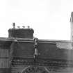
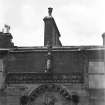
Excavation (17 November 2016 - 24 August 2017)
Under the terms of its PIC call-off contract with Historic Environment Scotland, Kirkdale Archaeology was asked to carry out a program of archaeological recording on the roof of the Palace Block at Stirling Castle, Stirling.
Inspection of these chimneys by UAV had indicated that many of them were in a poor state and required repair. To this end HES arranged for contractor’s to erect a major scaffolding structure, rising from the central courtyard of the palace (known as the Lion’s Den) to its roof, with walkways running from this out to individual chimneys.
Upon starting the program of archaeological recording it was obvious that three chimneys (RC01, RC02 and RC14) were in such a poor state or repair that they would have to be partially taken down and rebuilt.
A detailed photographic record was made of each chimney, and at least two sides (and usually all four sides) were drawn and a plan was made of the chimney head, all at an appropriate scale. Context numbers were assigned to all changes of build or additions to the chimney, these numbers were then marked on the drawings. Pro forma context sheets were used to give detailed written descriptions of the more significant contexts.
This work showed how much architectural information can be gleaned from the more inaccessible parts of a building. The areas that are not easily visible often retain information that may be ‘tidied up’ in more public spaces.
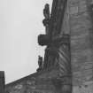
There is a definite style to the Palace period chimneys, with the use of ashlar masonry in coarse grained typically pale yellow, sometimes pale grey sandstone. Faint traces of diagonal tool marks often survived on these builds. The possibility that RC11 carries an original Palace period moulded top has been suggested. This would be the only example, although RC06 seems to have a later copy of the same moulding.
The original chimneys also display a certain economy when deploying this ashlar masonry; areas that cannot be seen from the ground are invariably random rubble. This is best seen in the east face of RC11, where there are three different builds of progressively higher quality as the chimney rises.
Significant evidence was also recorded for the scale of the remodelling of the roof in the late 17th century. This extended to the reconstruction of tops of two of the more imposing chimneys; RC05 and RC09. The distinctive sloping shoulders that these display are thought to relate to this period, and the entire east face of RC05 (the most visible when entering the castle) seems to have been taken down and rebuilt in the new style.
Dormer roofs still exist today connecting RC05, RC06 and RC11 to the current Palace roof. Evidence for the former existence of these was recorded on RC09 and RC12, and RC11 showed evidence for an earlier roof. These are thought to relate to the remodelled 17th century roof, but since so little is known about the original roof they could be older.
Dating evidence is poor for most of the smaller chimneys. RC08 and RC10 seem to be early 18th century, judging from images of the Palace. RC14 is thought to be inserted in the 18th century. Most of the others are probably 18th or 19th century as well, although both RC04 and RC12 have unique features that could mark them out as older.
G Ewart 2017
Sponsor: Historic Scotland
Kirkdale Archaeology
Measured Survey
Drawings by J Gillespie in the National Art Survey of Scotland Collection.
Measured Survey
Drawings by A Muir in the National Art Survey of Scotland Collection.

