
Pricing Change
New pricing for orders of material from this site will come into place shortly. Charges for supply of digital images, digitisation on demand, prints and licensing will be altered.
Blackhill


Ring Ditch (Prehistoric), Roundhouse (Prehistoric), Unenclosed Settlement (Prehistoric)
Site Name Blackhill
Classification Ring Ditch (Prehistoric), Roundhouse (Prehistoric), Unenclosed Settlement (Prehistoric)
Canmore ID 14213
Site Number NH74NW 25
NGR NH 71541 48149
NGR Description Centred on NH 71541 48149
Datum OSGB36 - NGR
Permalink http://canmore.org.uk/site/14213


- Council Highland
- Parish Petty
- Former Region Highland
- Former District Inverness
- Former County Inverness-shire
Field Visit (February 1978)
Blackhill NH 715 482 NH 4NW
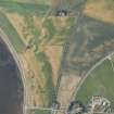
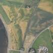
Air photography has revealed the crop-marks of what may be an unenclosed settlement 330m NW of Blackhill. It comprises a ring-ditch, which measures about 11 m in diameter, and a pit-circle measuring about 8m in diameter. See also NH74NW 26 and NH64SE 37.
Visible on RCAHMSAP 1977.
RCAHMS 1979, visited February 1978
Aerial Photographic Transcription (30 October 1991 - 11 November 1991)
An aerial transcription was produced from oblique aerial photographs. Information from Historic Environment Scotland (BM) 31 March 2017.
Aerial Photographic Interpretation (26 February 2014)
Following a review of the aerial photographic evidence, the circle of pits recorded as cropmarking on aerial photographs is thought to represent the remains of a later prehistoric roundhouse belonging to an unenclosed settlement. As such the pit circle classification previously applied has been removed and replaced with roundhouse.
Information from RCAHMS (KMM) 26 February 2014

