
Cardross, Geilston House


House (18th Century)
Site Name Cardross, Geilston House
Classification House (18th Century)
Canmore ID 141629
Site Number NS37NW 30
NGR NS 34016 78278
Datum OSGB36 - NGR
Permalink http://canmore.org.uk/site/141629


- Council Argyll And Bute
- Parish Cardross (Argyll And Bute)
- Former Region Strathclyde
- Former District Dumbarton
- Former County Dunbartonshire
NS37NW 30.00 34016 78278
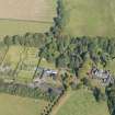
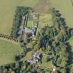
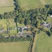
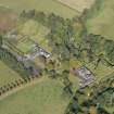
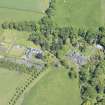
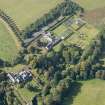
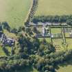
NS 339 783 Detailed topographic, standing building and vegetational surveys of Geilston House and Garden were commissioned to establish the history, character and cultural significance of the property. Documentary research found the estate had its origins in the late 1500s, then subsequently passed to six other families before it was gifted to the National Trust for Scotland in 1997.
Detailed standing building survey of the B Listed house established that it had developed through ten main phases, from 1666 (the likely date on a much-eroded datestone over a former entrance) or earlier. It began as a modest thatched laird's house, was expanded to become a villa, and finally a cottage ornee linked to a newly built walled garden, with views to the Clyde. The entire house appears to have been thatched until the early 19th century.
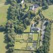
The landscape similarly developed in six main phases. It began to be enclosed and Improved after the Montgomery Act of 1770, and shelter belts and other plantings were probably added from this time onward. The next half-century saw the addition of stable blocks (in two phases), a pavilion doocot, a kitchen garden with a stone-lined tank, and a woodland glen garden with some exotic plantings. In the mid-19th century a conservatory, a Wellingtonia and a Mackenzie & Moncur greenhouse were added to the walled garden. The property's last owners, the Hendrys, gave the house a rear guest wing and also acquired a piece of land on the E side of the burn, the site of the Kilmahew Mill. Established as a corn mill in the 1830s, it also saw phases of use as a lint mill and finally a saw mill for a large Clyde shipbuilding firm before it burnt down in 1912.
A full report and archive will be lodged with the NMRS.
Sponsor: National Trust for Scotland
O Lelong 1998
NS 3401 7827 A test pit was dug in May 2003 inside the E end of the earliest part of Geilston House, believed to be 17th century. Between the timber joists was a loose build up of plaster and soil containing bone, glass and some organic material. The further from the front wall, the less organic material there was; this could either be result of animal activity or draughts. Below the joists was a compact plaster surface containing lumps of mortar, either an old floor surface (although it was a bit fragile) or a residue from plasterworking. Below this thin layer was a brown silty soil, 0.16m deep, which overlay a similar but more gravelly soil at least 0.28m deep. It is not possible to tell whether the last two layers, which were sterile of artefacts, represented natural subsoil or imported material used to build up the foundations.
On the exterior of the house at this point, a single pit was excavated to determine the depth of the foundations. Unfortunately the base of the wall was masked by a thick concrete foundation. Probing beyond this foundation located a solid surface at a depth of 1.4m below the surface.
Archive to be deposited in the NMRS.
Sponsor: NTS.
D Alexander 2003
NS37NW 30.00 34016 78278
NS37NW 30.01 33898 78320 Stables
NS37NW 30.02 33911 78302 Dovecot
NS37NW 30.03 34046 78307 Walled garden
Excavation (18 March 2011)
NS 3391 7828 A large stone block was discovered by gardeners creating a new garden border close to the car park at Geilston House. An excavation around the block on 18 March 2011 showed it to be a large boulder, 0.90m long by 0.85m wide and up to 0.28m thick. The block had a drilled socket, measuring 0.05m in diameter and 0.06m deep towards the SW corner. The block was joined to a smaller separate stone, 0.7 x 0.5m, by two iron staples. This smaller stone lay to the SE of the former. It is unclear why the two stones are joined together with iron brackets, but the most convincing explanation is that the larger stone with the drilled socket was the footing for an iron fence post.
Archive: RCAHMS (intended)
Funder: The National Trust for Scotland
The National Trust for Scotland, 2011
Standing Building Recording (May 2011 - September 2011)
NS 34016 78278 As the result of a leaking roof, parts of the house have suffered from dampness, which in turn led to a major outbreak of dry rot. This problem has been rectified but emergency works were required to assess and remove the contaminated material. The investigative work and removal of the affected material was monitored, and the newly exposed surfaces and areas recorded. This work was carried out during three site visits in May, June and September 2011.
The construction of the decorative niches in the W wall of the morning room was recorded and the removal of plaster, to the W of the fireplace uncovered a window. This was identical to the window to the E of the fireplace, and had been blocked from the outside and the internal face covered with lath and plaster. Further recording was carried out at the SE corner of the oldest part of the house, which dates to c1666. Evidence was uncovered suggesting there had originally been a window in this area (at the E end of the S frontage), before later additions were made in the 18th century.
Archive: RCAHMS
Funder: The National Trust for Scotland
Addyman Archaeology, 2011

