
Pricing Change
New pricing for orders of material from this site will come into place shortly. Charges for supply of digital images, digitisation on demand, prints and licensing will be altered.
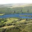
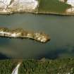
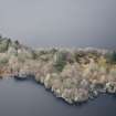
Isle Of Moy


House (Period Unassigned)
Site Name Isle Of Moy
Classification House (Period Unassigned)
Alternative Name(s) 'Isle Of Moy, Fortified Island And Laird's House'
Canmore ID 14136
Site Number NH73SE 2
NGR NH 7760 3425
Datum OSGB36 - NGR
Permalink http://canmore.org.uk/site/14136


- Council Highland
- Parish Moy And Dalarossie
- Former Region Highland
- Former District Inverness
- Former County Inverness-shire
NH73SE 2 7760 3425
See also NH73SE 11 and NH73SE 30.
(NH 7760 3425) Castle (NR) (rems of)
OS 1:10,000 map, (1975)
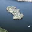
The Statistical Account (OSA) describes the remains of a house containing four firerooms, where the Lairds of Mackintosh resided in times of trouble, at the S end of the Isle of Moy. An inscription above the gate indicated that it was built in 1665 by Lachlan, the 20th Laird of Mackintosh. The remains of a street, the whole length of the island with the foundations of houses on each side, were also clearly visible.
A very recent investigation has shown that the gate and inscription have vanished, but the foundations and ruined walls of a rectangular house may be seen (at NH 7760 3425). The S gable still stands 9ft high; the walls, of well-built mortared rubble masonry average 3ft in thickness. Much debris surrounds the ruins, and the inner apartments cannot at present be delineated. The internal dimensions are 52 1/2ft N-S and 15 1/2ft E-W; the thick walls at ground level suggest two storeys at least. However, this building has no castellated features, no defences, and was obviously domestic in style. It stands at the SW corner of an enlosure, evidently a walled garden, measuring about 116ft N-S by some 61ft E-W; only the foundations of the dry-stone walls remain. It may be conjectured that this building was similar to other laird's hall-houses of the period.
Immediately S of the house, and outside the enclosure wall is the ruin of a small dry-stone building, about 20ft by 15ft. Its purpose is not clear.
There are little traces of the "street" and "foundations" noted in the OSA. The houses, very likely of stone and turf walls with thatched roofs, have evidently been removed by landscaping.
OSA 1793; E A Meldrum 1972.
This building, a laird's house, not a castle, is as described by Meldrum. The small dry-stone building mentioned by him is attached to its S gable. Nothing is visible of the village. (The Mackintosh of Moy requests that the name "Castle" be removed, and the building left undescribed)
Surveyed at 1:2500. (See also NH73NE 1)
Visited by OS (A A)27 September 1972.
Scheduled as 'Isle of Moy, fortified island and laird's house... a largely artificial island in Loch Moy.'
[The Scheduled area includes the obelisk NH73SE 30].
Information from Historic Scotland, scheduling document dated 21 March 2007.

