
Following the launch of trove.scot in February 2025 we are now planning the retiral of some of our webservices. Canmore will be switched off on 24th June 2025. Information about the closure can be found on the HES website: Retiral of HES web services | Historic Environment Scotland
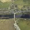
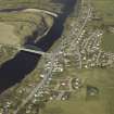
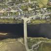
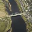
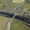
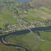
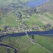
Bonar Bridge, Telford Bridge


Road Bridge (19th Century) (1812)
Site Name Bonar Bridge, Telford Bridge
Classification Road Bridge (19th Century) (1812)
Alternative Name(s) Bonar Bridge, Old Bridge; Kyle Of Sutherland
Canmore ID 14053
Site Number NH69SW 61
NGR NH 60930 91528
NGR Description NH c. 60930 91528
Datum OSGB36 - NGR
Permalink http://canmore.org.uk/site/14053


- Council Highland
- Parish Kincardine (Sutherland)
- Former Region Highland
- Former District Sutherland
- Former County Ross And Cromarty
NH69SW 61 c. 60930 91528
Bonar Bridge (Iron) [NAT]
OS (GIS) ep. 1.
Location formerly entered as NH 6093 9154
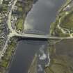
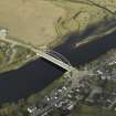
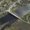
For (adjacent) present and successor bridges, see NH69SW 62.00 and NH69SW 62.01 respectively.
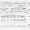
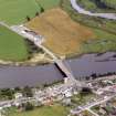
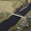
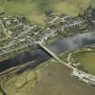
Telford's Bonar Bridge was built in 1812 and was similar to that at Craigellachie (NJ24NE 15). Telford intended it to have two identical cast-iron arches, but the absence of a suitable rock base on the S side caused it to be built with two masonry spans and an iron one of 150 ft (45.7m). It survived the impacts of fir trunks and a ship, but collapsed in January 1892 when it was undermined by flood water.
G Nelson 1990.
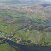
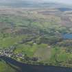
This bridge formerly carried the Inverness - Wick public road (now the A9) over the Kyle of Sutherland, which here forms the boundary between the parishes of Kincardine (to the SW) and Creich (to the NE). The 1st edition of the OS map (GIS ep. 1) places the centre of the span at NH 60930 91528
Information from RCAHMS (RJCM), 5 May 1998.
Publication Account (2007)
Bonar Bridge
The first bridge built on this site (see also NH69SW 62.00 and NH69SW 62.01) by Simpson and Cargill, contractors for both masonry and ironwork, incorporated Telford’s innovative light prefabricated cast-iron lattice spandrel arch of 150 ft span designed in 1810 and pre-erected by ironfounder William Hazledine at Ruabon in June 1812.
Originally, one arch was thought to provide sufficient waterway if founded on rock but, because of foundation difficulties, this was not possible and, after considering twin rim arches additional masonry spans of 50 ft and 60 ft were adopted to reduce the pressure on the iron bridge pier in times of flood. The bridge was erected in 1812 at a cost of £13 971 (ironwork £3947).
This project, involving the longest such prefabricated span in 1812, constituted an epoch-making iron bridge development. By 1830 at least ten arches of this genre had been erected in Britain as far south as Tewkesbury, of which the second, at Craigellachie (NJ24NE 15 ), is now the earliest survivor. Many later bridges until the turn of the century, for example Carron (1862-3, NJ24SW 14), were influenced in their appearance by the lattice spandrel elevation of this bridge type.
R Paxton and J Shipway, 2007.
Reproduced from 'Civil Engineering heritage: Scotland - Highlands and Islands' with kind permission from Thomas Telford Publishers.

