
Muirkirk, Station


Railway Station (19th Century) - (20th Century)
Site Name Muirkirk, Station
Classification Railway Station (19th Century) - (20th Century)
Alternative Name(s) Muirkirk Station
Canmore ID 139857
Site Number NS62NE 45
NGR NS 6964 2658
Datum OSGB36 - NGR
Permalink http://canmore.org.uk/site/139857


- Council East Ayrshire
- Parish Muirkirk
- Former Region Strathclyde
- Former District Cumnock And Doon Valley
- Former County Ayrshire
NS62NE 45 6964 2658.
see also: NS62NE 45.01 6960 2658 Railway Underbridge.
NS62NE 45.02 6960 2650 Station Cottage
Station [NAT]
OS 1:10560 map, 1897.
Station House [NAT]
OS 1:10,000 map, 1980.
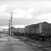
This station was opened in 1896 to replace the old station (NS62NE 44) as the terminus of the Muirkirk branch of the (former) Glasgow and South-Western Rly, and closed to regular passenger traffic on 5 October 1964.
This line had an end-on junction with the Carstairs - Glenbuck - Muirkirk junction of the (former) Caledonian Rly.
Information from RCAHMS (RJCM), 29 January 1999.
R V J Butt 1995.

