
St Kilda, Soay, General


General View (Period Unassigned)
Site Name St Kilda, Soay, General
Classification General View (Period Unassigned)
Alternative Name(s) Soaigh
Canmore ID 139772
Site Number NA00SE 8
NGR NA 0650 0150
NGR Description Centred on NA 0650 0150
Datum OSGB36 - NGR
Permalink http://canmore.org.uk/site/139772
Ordnance Survey licence number AC0000807262. All rights reserved.
Canmore Disclaimer.
© Bluesky International Limited 2025. Public Sector Viewing Terms
- Correction
- Favourite

DP 046580
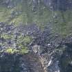
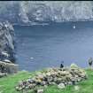
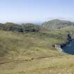
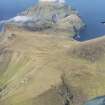
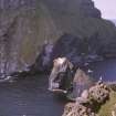
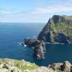
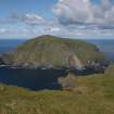
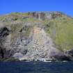
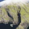
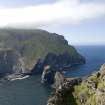
St Kilda, Soay. View from The Cambir on Hirta looking NW to the scree slopes above Mol Shoay where several structures have been recorded.
Records of the Royal Commission on the Ancient and Historical Monuments of Scotland (RCAHMS), Edinbu
16/5/2008
© Crown Copyright: HES

DP 134164
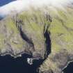
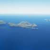
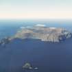
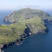
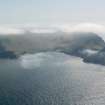
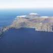
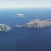
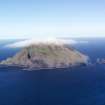
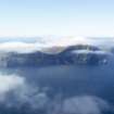
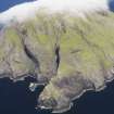
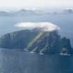
General oblique aerial view of St Kilda, centred on the island of Soay, taken from the SSW.
RCAHMS Aerial Photography Digital
2/5/2012
© Crown Copyright: HES

DP 134186
General oblique aerial view of St Kilda, taken from the NE.
RCAHMS Aerial Photography Digital
2/5/2012
© Crown Copyright: HES

DP 166200
1979-02 Soay village slope before the landslide, 8 August.
Stuart Murray
1979
© Copyright: Stuart Murray. Courtesy of HES.

DP 166312
W Wright (Warden) & Mary Harman, Soay.
Stuart Murray
12/7/1977
© Copyright: Stuart Murray. Courtesy of HES.

DP 251225
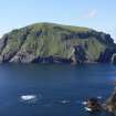
Soay from Geo na Stacan, Hirta
Records of the Royal Commission on the Ancient and Historical Monuments of Scotland (RCAHMS), Edinbu
13/5/2007
© Crown Copyright: HES

DP 251227
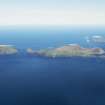
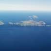
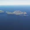
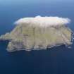
Soay from NW Hirta
Records of the Royal Commission on the Ancient and Historical Monuments of Scotland (RCAHMS), Edinbu
13/5/2007
© Crown Copyright: HES

SC 722684
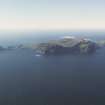
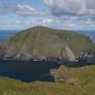
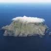
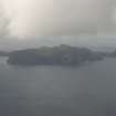
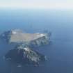
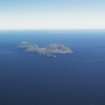
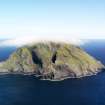
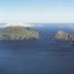
Oblique aerial view showing the island of Soay in the St Kilda archipelago.
Photoair Limited: Aerial Imagery (Scotland)
6/1995
© Courtesy of HES (Photoair Limited: Aerial Imagery (Scotland))

DP 046598
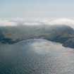
St Kilda, Hirta and Soay. General view from SE across Gleann Mor and The Cambir with Soay beyond.
Records of the Royal Commission on the Ancient and Historical Monuments of Scotland (RCAHMS), Edinbu
16/5/2008
© Crown Copyright: HES

DP 134100
General oblique aerial view of St Kilda, taken from the SSW.
RCAHMS Aerial Photography Digital
2/5/2012
© Crown Copyright: HES

DP 134107
General oblique aerial view of St Kilda, taken from the NE.
RCAHMS Aerial Photography Digital
2/5/2012
© Crown Copyright: HES

DP 134231
General oblique aerial view of St Kilda, taken from the SE.
RCAHMS Aerial Photography Digital
2/5/2012
© Crown Copyright: HES

DP 166241
2009-04 Soay village, after the landslide (8 May)
Stuart Murray
2009
© Copyright: Stuart Murray. Courtesy of HES.

DP 166243
2011-01 Soay landslide from Cambir_Carnmore path, 23 July.
Stuart Murray
2011
© Copyright: Stuart Murray. Courtesy of HES.

DP 166247
2011-05 Soay landslide, top edge, looking across from the bothy, 24 July.
Stuart Murray
2011
© Copyright: Stuart Murray. Courtesy of HES.

SC 1483255
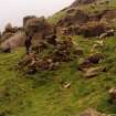
St Kilda, Soay. Peat cutting on S edge of top plateau.
Papers of Dr Mary Harman, archaeologist, Edinburgh, Scotland
1989
© Copyright: Mary Harman. Courtesy of HES.

DP 046604
St Kilda, Boreray. Stac Lee, with Hirta and Soay in the distance.
Records of the Royal Commission on the Ancient and Historical Monuments of Scotland (RCAHMS), Edinbu
16/5/2008
© Crown Copyright: HES

DP 134167
General oblique aerial view of St Kilda, centred on the island of Soay, taken from the S.
RCAHMS Aerial Photography Digital
2/5/2012
© Crown Copyright: HES

DP 134185
General oblique aerial view of St Kilda, taken from the E.
RCAHMS Aerial Photography Digital
2/5/2012
© Crown Copyright: HES

DP 134203
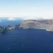
General oblique aerial view of St Kilda, centred on Gleann Mor and the island of Soay, taken from the ESE.
RCAHMS Aerial Photography Digital
2/5/2012
© Crown Copyright: HES

DP 166199
Soay village slope before the landslide. (S Murray foreground, 8 August).
Stuart Murray
8/8/1979
© Copyright: Stuart Murray. Courtesy of HES.

DP 166202
2007-01 The Soay landslide 7 February (photo. S Bain).
Stuart Murray
7/2/2007
© Copyright: Stuart Murray. Courtesy of HES.

DP 166311
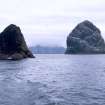
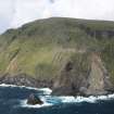
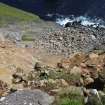
Landing at Geo nan Ron, Soay.
Stuart Murray
12/7/1977
© Copyright: Stuart Murray. Courtesy of HES.

DP 167171
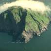
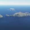
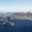
General oblique aerial view of Hirta and Soay, St Kilda, looking to the SW.
RCAHMS Aerial Photography Digital
6/9/2013
© Crown Copyright: HES

DP 345070
General view from Soay to An Cambir, Hirta
Records of the Royal Commission on the Ancient and Historical Monuments of Scotland (RCAHMS), Edinbu
24/7/2011
© Copyright: Jill Harden. Courtesy of HES.

DP 046579
St Kilda, Soay. View from The Cambir on Hirta looking NW to the scree slopes above Mol Shoay where several structures have been recorded.
Records of the Royal Commission on the Ancient and Historical Monuments of Scotland (RCAHMS), Edinbu
16/5/2008
© Crown Copyright: HES

DP 046597
St Kilda, Hirta and Soay. View from SE across Glen Bay and The Cambir with Soay beyond.
Records of the Royal Commission on the Ancient and Historical Monuments of Scotland (RCAHMS), Edinbu
16/5/2008
© Crown Copyright: HES

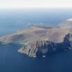
DP 134099
General oblique aerial view of St Kilda, taken from the SW.
RCAHMS Aerial Photography Digital
2/5/2012
© Crown Copyright: HES

DP 134115
General oblique aerial view of St Kilda, centred on Gleann Mor, taken from the NNW.
RCAHMS Aerial Photography Digital
2/5/2012
© Crown Copyright: HES

DP 134222
General oblique aerial view of St Kilda, taken from the NW.
RCAHMS Aerial Photography Digital
2/5/2012
© Crown Copyright: HES

DP 134225
General oblique aerial view of St Kilda, taken from the SSW.
RCAHMS Aerial Photography Digital
2/5/2012
© Crown Copyright: HES

DP 134226
General oblique aerial view of St Kilda, taken from the SW.
RCAHMS Aerial Photography Digital
2/5/2012
© Crown Copyright: HES

DP 134229
General oblique aerial view of St Kilda, taken from the S.
RCAHMS Aerial Photography Digital
2/5/2012
© Crown Copyright: HES

DP 166232
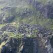
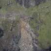
General view of Soay, showing landslide.
Stuart Murray
7/2/2007
© Copyright: Stuart Murray. Courtesy of HES.

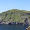
SC 1475395
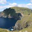
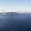
View of Soay looking NW from Hirta.
Papers of Dr J N Graham Ritchie, and Dr Anna Ritchie, archaeologists, Edinburgh, Scotland
6/1984
© RCAHMS

SC 1483265
St Kilda, Soay. Wall above an Airde, from W
Papers of Dr Mary Harman, archaeologist, Edinburgh, Scotland
1977
© Copyright: Mary Harman. Courtesy of HES.

DP 251226
Soay from NW Hirta
Records of the Royal Commission on the Ancient and Historical Monuments of Scotland (RCAHMS), Edinbu
13/5/2007
© Crown Copyright: HES

SC 416625
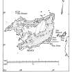
Publication drawing; St Kilda. Soay: physical features. Photographic copy.
Records of the Royal Commission on the Ancient and Historical Monuments of Scotland (RCAHMS), Edinbu
c. 1986
© Crown Copyright: HES

DP 046581
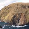
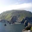
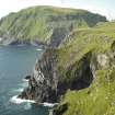
St Kilda, Soay. General view The Cambir on Hirta including Stac Dona, Stac Biorach and Soay Stac.
Records of the Royal Commission on the Ancient and Historical Monuments of Scotland (RCAHMS), Edinbu
16/5/2008
© Crown Copyright: HES

SC 1225645
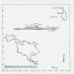
Publication drawing; St Kilda archipelago.
Records of the Royal Commission on the Ancient and Historical Monuments of Scotland (RCAHMS), Edinbu
c. 1986
© Crown Copyright: HES

DP 134117
General oblique aerial view of St Kilda, centred on the island of Soay, taken from the SSE.
RCAHMS Aerial Photography Digital
2/5/2012
© Crown Copyright: HES

DP 134184
General oblique aerial view of St Kilda, taken from the E.
RCAHMS Aerial Photography Digital
2/5/2012
© Crown Copyright: HES

DP 134219
General oblique aerial view of St Kilda, taken from the E.
RCAHMS Aerial Photography Digital
2/5/2012
© Crown Copyright: HES

DP 134223
General oblique aerial view of St Kilda, taken from the WSW.
RCAHMS Aerial Photography Digital
2/5/2012
© Crown Copyright: HES

DP 134224
General oblique aerial view of St Kilda, taken from the WSW.
RCAHMS Aerial Photography Digital
2/5/2012
© Crown Copyright: HES

DP 134227
General oblique aerial view of St Kilda, taken from the SSW.
RCAHMS Aerial Photography Digital
2/5/2012
© Crown Copyright: HES

DP 166201
1979-03 Soay village, before the landslide. Compare with 2007-03 & 2009-03.
Stuart Murray
1979
© Copyright: Stuart Murray. Courtesy of HES.

DP 166233
General view of Soay, after the landslide.
Stuart Murray
8/5/2009
© Copyright: Stuart Murray. Courtesy of HES.

DP 166242
2009-05 Landslide from the village into Mol Carn Liana, 12th May.
Stuart Murray
2009
© Copyright: Stuart Murray. Courtesy of HES.

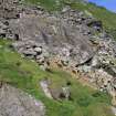
SC 1483254
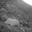
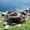
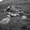
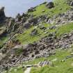
St Kilda, Soay. View of bothies, etc and campsite, with Cleit 28 in the background.
Papers of Dr Mary Harman, archaeologist, Edinburgh, Scotland
1989
© Copyright: Mary Harman. Courtesy of HES.

DP 251826
View to Soay from The Cambir, Hirta
Records of the Royal Commission on the Ancient and Historical Monuments of Scotland (RCAHMS), Edinbu
8/2009
© Crown Copyright: HES

DP 134108
General oblique aerial view of St Kilda, taken from the ENE.
RCAHMS Aerial Photography Digital
2/5/2012
© Crown Copyright: HES

DP 134118
General oblique aerial view of St Kilda, centred on the island of Soay, taken from the S.
RCAHMS Aerial Photography Digital
2/5/2012
© Crown Copyright: HES

DP 134120
General oblique aerial view of St Kilda, centred on the island of Soay, taken from the S.
RCAHMS Aerial Photography Digital
2/5/2012
© Crown Copyright: HES

DP 134127
General oblique aerial view of St Kilda, centred on Village Bay and the island of Dun, taken from the SSE.
RCAHMS Aerial Photography Digital
2/5/2012
© Crown Copyright: HES

DP 134128
General oblique aerial view of St Kilda, centred on Village Bay and the island of Dun, taken from the E.
RCAHMS Aerial Photography Digital
2/5/2012
© Crown Copyright: HES

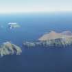
DP 134163
General oblique aerial view of St Kilda, centred on the island of Soay, taken from the SW.
RCAHMS Aerial Photography Digital
2/5/2012
© Crown Copyright: HES

DP 134230
General oblique aerial view of St Kilda, taken from the SSE.
RCAHMS Aerial Photography Digital
2/5/2012
© Crown Copyright: HES

DP 251328
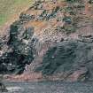
Rock slide on Soay
Records of the Royal Commission on the Ancient and Historical Monuments of Scotland (RCAHMS), Edinbu
13/5/2007
© Crown Copyright: HES

DP 251593
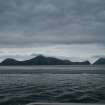
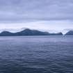
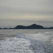
Dun, Hirta and Soay silhouettes from the sea
Records of the Royal Commission on the Ancient and Historical Monuments of Scotland (RCAHMS), Edinbu
16/5/2008
© Crown Copyright: HES

DP 345063
Soay cleit
Records of the Royal Commission on the Ancient and Historical Monuments of Scotland (RCAHMS), Edinbu
24/7/2011
© Copyright: Jill Harden. Courtesy of HES.

DP 046582
St Kilda, Soay. General view The Cambir on Hirta including Stac Dona, Stac Biorach and Soay Stac.
Records of the Royal Commission on the Ancient and Historical Monuments of Scotland (RCAHMS), Edinbu
16/5/2008
© Crown Copyright: HES

DP 046608
St Kilda, Hirta, Dun and Soay. Silhouette of the archipelago from the sea.
Records of the Royal Commission on the Ancient and Historical Monuments of Scotland (RCAHMS), Edinbu
16/5/2008
© Crown Copyright: HES

DP 134106
General oblique aerial view of St Kilda, taken from the NE.
RCAHMS Aerial Photography Digital
2/5/2012
© Crown Copyright: HES

DP 134114
General oblique aerial view of St Kilda, centred on Gleann Mor, taken from the NNW.
RCAHMS Aerial Photography Digital
2/5/2012
© Crown Copyright: HES

DP 134165
General oblique aerial view of St Kilda, centred on the island of Soay, taken from the SSW.
RCAHMS Aerial Photography Digital
2/5/2012
© Crown Copyright: HES

DP 134166
General oblique aerial view of St Kilda, centred on the island of Soay, taken from the S.
RCAHMS Aerial Photography Digital
2/5/2012
© Crown Copyright: HES

DP 134228
General oblique aerial view of St Kilda, taken from the SSW.
RCAHMS Aerial Photography Digital
2/5/2012
© Crown Copyright: HES

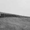
DP 164900
St Kilda, Soay, Bothy. Photograph by Stuart Murray.
Records of the Royal Commission on the Ancient and Historical Monuments of Scotland (RCAHMS), Edinbu
5/1997
© Copyright: Stuart Murray. Courtesy of HES.

DP 166234
Soay, the main area of structures after the landslide.
Stuart Murray
8/5/2009
© Copyright: Stuart Murray. Courtesy of HES.

DP 166244
2011-02 Soay landslide from Carnmore path, 23 July.
Stuart Murray
2011
© Copyright: Stuart Murray. Courtesy of HES.

DP 166246
2011-04 Soay landslide, from top edge looking down, 24 July.
Stuart Murray
2011
© Copyright: Stuart Murray. Courtesy of HES.

SC 1483266
St Kilda, Soay. Wall above an Airde, from E
Papers of Dr Mary Harman, archaeologist, Edinburgh, Scotland
1977
© Copyright: Mary Harman. Courtesy of HES.

DP 251263
Dun, Hirta and Soay from the sea
Records of the Royal Commission on the Ancient and Historical Monuments of Scotland (RCAHMS), Edinbu
15/5/2007
© Crown Copyright: HES

DP 134187
General oblique aerial view of St Kilda, centred on the island of Boreray, taken from the NE.
RCAHMS Aerial Photography Digital
2/5/2012
© Crown Copyright: HES

DP 166230
2007-02 The Soay landslide 7 February (photo. S Bain).
Stuart Murray
7/2/2007
© Copyright: Stuart Murray. Courtesy of HES.

DP 166231
Soay village, close up of the bothy, 7 February (photo. S Bain).
Stuart Murray
7/2/2007
© Copyright: Stuart Murray. Courtesy of HES.

DP 166245
2011-03 Soay landslide, top edge from above, 24 July.
Stuart Murray
2011
© Copyright: Stuart Murray. Courtesy of HES.

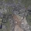
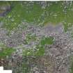
DP 285810
Photomerge showing structures on Soay and site numbers
Papers of Dr George F Geddes, archaeologist, Edinburgh, Scotland
2018
© Copyright: G F Geddes. Courtesy of HES.


- Council Western Isles
- Parish Harris
- Former Region Western Isles Islands Area
- Former District Western Isles
- Former County Inverness-shire

