
Point Of Stoer, Meall An Sgriobain, Chain Home Low Radar Station


Radar Station (20th Century)
Site Name Point Of Stoer, Meall An Sgriobain, Chain Home Low Radar Station
Classification Radar Station (20th Century)
Alternative Name(s) Meall Dubh Raffin
Canmore ID 139434
Site Number NC03SW 21
NGR NC 0080 3292
NGR Description Centred NC 0080 3292
Datum OSGB36 - NGR
Permalink http://canmore.org.uk/site/139434


- Council Highland
- Parish Assynt
- Former Region Highland
- Former District Sutherland
- Former County Sutherland
NC03SW 21.00 centred 0800 3292
NC03SW 21.01 centred NC 0215 3215 Military Camp
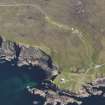
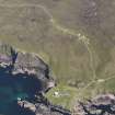
NGR quoted NC 008 329, falls in sea. A Chain Home Low radar station on the NW-facing slopes of Meall Dubh Raffin.
Information from Mr I Brown, November 1998
Situated on the hill to the E of Stoer Lighthouse (NC03SW 6) up a track leading from the road. Constructed of stone, concrete and brick, there are hut-bases, the main power-house and standby set-house with blast walls. Both the Transmitter and Receiver block is also protected by blast walls on which there is the date 1941 carved. The base for the aerial and one shelter also survive. The accommodation camp (NC03SW 21.01) is about a mile down the road at Rubha Stoer.
J Guy 2000; NMRS MS 810/10, Part 1, 1, 2-3, Vol.3, 1-3
The Radar Station is depicted on the OS 1:10000 scale map (1971), which shows four buildings, including theTx/Rx block at NC 0079 3292. However only three buildings are depicted on the current OS 1:2500 digital maps, at NC 00887 32992 (Stand-by set house); NC 00784 32864 and NC 00750 32788, the Tx/Rx building is not shown on this version of the map.
The installation is visible on postwar RAF vertical air photographs (106G/Scot/UK163, 4386-4387, flown 23 August 1946), which shows that most of the Nissen huts had been removed at this date suggesting site had been abandoned.
Information from RCAHMS (DE), September 2004.

