
St Kilda, Hirta, Village Bay, Blackhouse F


Blackhouse (Post Medieval)
Site Name St Kilda, Hirta, Village Bay, Blackhouse F
Classification Blackhouse (Post Medieval)
Canmore ID 139385
Site Number NF19NW 21.29
NGR NF 10147 99361
Datum OSGB36 - NGR
Permalink http://canmore.org.uk/site/139385


- Council Western Isles
- Parish Harris
- Former Region Western Isles Islands Area
- Former District Western Isles
- Former County Inverness-shire
NF19NW 21.29 10147 99361
Excavation (16 April 2011 - 13 September 2011)
NF 1010 9930 A full season of fieldwork 16 April–13 September 2011 included condition surveys, coastal erosion monitoring, conservation work and two small-scale excavations.
Blackhouse F A small trial trench was excavated within Blackhouse F, as part of the annual St Kilda Work Party conservation works. This blackhouse has been used for many years as a dumping ground for excess building materials, which the Trust is now gradually removing. In order to do this without risk to any in situ archaeological deposits a small trial trench was excavated to examine the deposits.
A trench was opened at the S end of the interior of the blackhouse, measuring 3.3m E–W and 0.8m N–S. Six contexts were recorded. No finds worthy of further study were encountered and the excavation was curtailed as soon as in situ archaeological deposits were recognised. The evidence indicated that a small camp-style fire took place in the SW corner of Blackhouse F shortly after the building had been abandoned and the roof had collapsed. Occupational debris had been dumped in the ruin during the 19th century and sometime after this sandy gravel and stones were dumped in the blackhouse by NTS work parties.
Blackhouse B The southern wall of this blackhouse abuts the main village street and had become extremely unstable. It was agreed to dismantle the exterior face, record all archaeological deposits encountered and then reinstate the wall. A written and drawn (plan section and elevation) record was produced of 20 contexts and bulk samples taken from in situ layers. The trench showed stratigraphic relationships which indicated at least two phases of wall, one of which was recent enough to contain concrete and a rubber plimsole. Finds of 19th- and 20th-century date were recovered from the soils, but returned to the wall during rebuilding, as per Trust policy.
Other discoveries A length of turf dyke on the SE side of Claigeann Mor; a section of wall at Bioda Mor, Dun; a wall cutting across the headland over the tunnel; two upright stones on Conachair; two pivot stones, one between house 9 and blackhouse K, and a stone with two pivot like depressions in the wall of enclosure 53; pumice stone from the roof of cleit 67; clay tiles in the eroding soils near the store; a line of WW1 postholes; and 7 sherds of unglazed handmade pottery from the eroding coastal cliff. A day survey was also undertaken on Soay.
Archive: RCAHMS and www.kilda.org.uk (intended). Reports: Western Isles SMR
Funder: Historic Scotland and the National Trust for Scotland
The National Trust for Scotland, 2011
Excavation (26 March 2012)
A small excavation was carried out in Blackhouse F on 26 March 2012.
(Acc No 2015/90)
Watching Brief (May 2013 - August 2013)
NF 1014 9936, NF 1006 9937 and NF 1029 9919 Three watching briefs were undertaken on Hirta, May–August 2013. Two during conservation works to post-medieval buildings within the scheduled ancient monument of Village Bay, and one during repairs to services within a modern MOD base.
The watching brief, undertaken during conservation repairs to the W wall of Blackhouse L, Village Bay, recorded an historic infill within the double-skinned walls of the blackhouse. The fill was sterile of finds but did contain evidence of peat ash and organic deposits, suggesting it may have been partially composed of midden material. Information from documentary sources indicated the blackhouse is 19th-century in date and the archaeological deposits are presumed to date to this period.
The watching brief undertaken during repairs to the SW corner of Blackhouse F revealed archaeological deposits consisting of a wall infill. An upper context of fill contained an assemblage of late 19th-/early 20th-century glass and ceramics. A lower fill context was sterile of finds but was composed of what appeared to be midden material. The lower context was interpreted as infill associated with the original construction of the blackhouse in the 1830s, whilst the upper was thought likely to represent a repair undertaken in the late 19th or early 20th century.
No finds or features of archaeological significance were recorded during excavations associated with the repair of a water pipe to the rear of the MOD base in Village Bay.
Archive: RCAHMS and Museum nan Eilean
Funder: The National Trust for Scotland with support from Historic Scotland
Kevin Grant, The National Trust for Scotland, 2013
(Source: DES)
Watching Brief (April 2014 - July 2014)
NF 1014 9936 (Blackhouse F) and NF 10128 99361 (Blackhouse G) Two watching briefs were undertaken, April – July 2014, at Village Bay. The first one was undertaken during the removal of post-1957 rubble from the interior of Blackhouse F, as part of ongoing conservation work by volunteer work parties. The removal of this deposit revealed an extremely heterogeneous context of building and household debris including glass, metal, ceramics, coal, and building materials, interpreted as post-occupational dumping or middening. An early 20th-century date for this use, suggested by archival photographs and documentary evidence, was confirmed by the artefacts recovered. The deposit was left in situ and the interior of the blackhouse was returfed. This excavation exemplifies a not uncommon biography of such structures in Village Bay, which have often
seen several phases of repair and changes of use throughout their lifetime.
The other watching brief in the 2014 season was undertaken during a large conservation repair to the S wall and gable of Blackhouse G, which revealed a number of internal infill contexts reflecting previous repairs to the blackhouse from the 19th to the late 20th century. The lowermost layer of soil infill exposed probably dated from the construction of the structure sometime in the 1830s. Although this early context was relatively sterile of finds, the discovery of a graphite stylus is evidence of early education on the island which predates the surviving late Victorian schoolhouse by at least 60 years.
Information from K. Grant – The National Trust for Scotland
(Source: DES)
OASIS ID: national3-185723
Field Visit (31 August 2014)
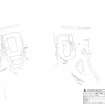
This blackhouse, constructed in the 1830s, stands end-on to the street and there is a small transversely aligned building at the upper end. This building was occupied by a succession of Fergusons beginning with John (1772-c1845) and his family (SAS Mss 158; Lawson 1993, 22). The croft later passed to the Gillies family who stayed in the adjacent House 6.
Set into the slope, the main unit measures 5.81m by 3.17m within walls over 1.6m thick and 1.6m in height internally at the N end. Poor bonding at all four corners suggests that the interior has been reduced in length at both ends; the unusually thin S end-wall may suggest that this wall has been reconstructed to allow a realignment of the street. The lintels of the door and window openings in the E wall are missing.
Internally, the transverse N unit measures 3.31m from E to W by 2.08m, the walls being up to 1.1m thick and 1.68m high. There are reused fragments of zinc roof sheeting in the N wallhead. A doorway in the E end-wall retains the door frame lintel. A drain runs around the N wall and flows into a slab drain along the E side-wall of the main unit. This annexe post dates the 1858 plan and is unusual in not being provided with a window.
Spoil accumulated in the interior by volunteers, particularly in connection with the renovation of House 6 (Johnstone 1998) was removed under archaeological supervision in 2014.
Visited by RCAHMS (GFG, AM, JM) 31 August 2014.
Measured Survey (29 August 2014 - 31 August 2014)
RCAHMS surveyed Blackhouse F (NF19 NW 21.29), Village Bay, St Kilda between 29-31 August 2014 with plane-table and alidade at a scale of 1:100. The resultant plan was redrawn in vector graphics software.

