
Polintark


Hut Circle(S) (Prehistoric)
Site Name Polintark
Classification Hut Circle(S) (Prehistoric)
Alternative Name(s) Mudh-a-blair
Canmore ID 13908
Site Number NH68SE 3
NGR NH 66623 82660
NGR Description NH 66623 82660 and NH 66627 82617
Datum OSGB36 - NGR
Permalink http://canmore.org.uk/site/13908


- Council Highland
- Parish Edderton
- Former Region Highland
- Former District Ross And Cromarty
- Former County Ross And Cromarty
NH68SE 3 666 826
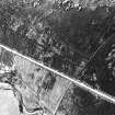
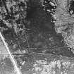
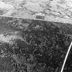
At NH 6662 8265 ('A') is an oval stone-walled hut measuring c.14.5m NW-SE by c.12.5m between the centres of a wall spread to c.3.0m all round. The simple entrance is in the SE.
There is no trace of contemporary cultivation. A complex of straight walls in the vicinity is recent. 45m to the S at NH 6662 8261 is another hut ('B') c.11.5m in diameter with an ill-defined entrance in the SE. A later rectangular building with an entrance in its S wall has been inserted into the hut.
Huts surveyed at 1:10,560.
Visited by OS (A A) 25 September 1973.
Field Visit (September 1978)
Polintark 1 NH 666 826 NH68SE 3
These two hut-circles stand 750m NW of Polintark in an area disturbed by peat-cutting.
RCAHMS 1979, visited September 1978

