|
Photographs and Off-line Digital Images |
E 04374 |
RCAHMS Aerial Photography |
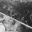
Oblique aerial view centred on the remains of the hut-circles, taken from the WNW. |
2/8/1991 |
Item Level |
|
|
Photographs and Off-line Digital Images |
E 04353 |
RCAHMS Aerial Photography |
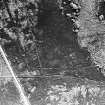
Oblique aerial view centred on the remains of the hut-circles, taken from the SE. |
2/8/1991 |
Item Level |
|
|
Photographs and Off-line Digital Images |
E 08082 |
RCAHMS Aerial Photography |
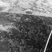
General oblique aerial view centred on the remains of the sheepfold and the hut-circles, taken from the NNW. |
2/8/1991 |
Item Level |
|
 |
On-line Digital Images |
SC 1695894 |
RCAHMS Aerial Photography |
Oblique aerial view centred on the remains of the hut-circles, taken from the SE. |
2/8/1991 |
Item Level |
|
 |
On-line Digital Images |
SC 1695895 |
RCAHMS Aerial Photography |
Oblique aerial view centred on the remains of the hut-circles, taken from the WNW. |
2/8/1991 |
Item Level |
|
 |
On-line Digital Images |
SC 1695903 |
RCAHMS Aerial Photography |
General oblique aerial view centred on the remains of the sheepfold and the hut-circles, taken from the NNW. |
2/8/1991 |
Item Level |
|
 |
Digital Files (Non-image) |
WP 007515 |
Publications by the Royal Commission on the Ancient and Historical Monuments of Scotland |
(6) The Archaeological Sites and Monuments of Easter Ross, Ross and Cromarty District |
2/1979 |
Item Level |
|
 |
On-line Digital Images |
SC 2365109 |
Records of the Ordnance Survey, Southampton, Hampshire, England |
Polintark, NH68SE 3, Ordnance Survey index card, Recto |
1958 |
Item Level |
|
 |
On-line Digital Images |
SC 2365110 |
Records of the Ordnance Survey, Southampton, Hampshire, England |
Polintark, NH68SE 3, Ordnance Survey index card, Recto |
1958 |
Item Level |
|
 |
On-line Digital Images |
SC 2365111 |
Records of the Ordnance Survey, Southampton, Hampshire, England |
Polintark, NH68SE 3, Ordnance Survey index card, Recto |
1958 |
Item Level |
|
|
All Other |
551 166/1/1 |
Records of the Ordnance Survey, Southampton, Hampshire, England |
Archaeological site card index ('495' cards) |
1947 |
Sub-Group Level |
|


