
Pricing Change
New pricing for orders of material from this site will come into place shortly. Charges for supply of digital images, digitisation on demand, prints and licensing will be altered.
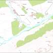
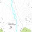
Allt A' Chaorainn, Limekiln


Lime Kiln (18th Century) - (19th Century), Pit (19th Century)
Site Name Allt A' Chaorainn, Limekiln
Classification Lime Kiln (18th Century) - (19th Century), Pit (19th Century)
Canmore ID 138308
Site Number NN69NE 6.01
NGR NN 6878 9956
Datum OSGB36 - NGR
Permalink http://canmore.org.uk/site/138308


- Council Highland
- Parish Kingussie And Insh
- Former Region Highland
- Former District Badenoch And Strathspey
- Former County Inverness-shire
Field Visit (9 November 1995)
NN69NE 6.01 6878 9956
This limekiln has been levelled into the leading edge of a terrace on the N side of the track along Glenbanchor and lies to the W of the township head-dyke (see NN 69NE 6.01). The bowl measures 2.5m in diameter within a facing of boulders by 0.7m in depth, with the flue on the SW. It is depicted on the 1st edition of the OS 6-inch map (Inverness-shire 1872, ci) as a circle with a central dot and annotated Limekiln.
On the knoll just to the N of the limekiln there is a pit of unknown function which measures about 3m in diameter, with some upcast.
(KING95 523)
Visited by RCAHMS (DCC) 9 November 1995

