Pricing Change
New pricing for orders of material from this site will come into place shortly. Charges for supply of digital images, digitisation on demand, prints and licensing will be altered.
RCAHMS Afforestable Land Survey, Kingussie


Date 1995 - 1996
Event ID 1045934
Category Project
Type Project
Permalink http://canmore.org.uk/event/1045934
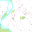
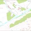
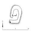
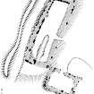
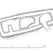
Newtonmore: a block of ground, stretching southwards along the west side of the Spey Valley from Kingussie to south of Newtonmore, was field surveyed in the autumn of 1995. Large numbers of post-medieval farmsteads were recorded, along with their associated shielings which were found at heights of up to 2700 feet - the highest found so far in Scotland. The survey also identified several clusters of hut circles indicating that the area was probably relatively densely settled by the first millennium BC.
RCAHMS (DES 1996, 121)
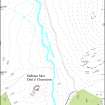
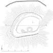
In the autumn of 1995 fieldwork was conducted in an area of 105 sq km to the west of Kingussie, extending to the head of Glen Banchor. The survey has revealed a much greater density of prehistoric settlement in this part of Upper Speyside than the existing record suggested, 32 hut-circles being recorded where only eight were known before. Huge numbers of buildings of the post-medieval period were also mapped, including groups of shielings in the Monadliath Mountains at altitudes as great as 800m (2625 feet), the highest yet recorded in Scotland. The recording of the palisaded site on top of Sidhean Mor Dail a'Chaorainn is an important addition to the record. The results of this survey are being prepared for deposition in the NMRS.
RCAHMS Annual Report 1995-6, 18-20