 |
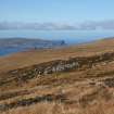
On-line Digital Images |
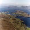
SC 1677067 |
RCAHMS Aerial Photography |
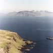
General oblique aerial view of SW corner of Canna (Bre Sgorr and An Steidh), looking ESE towards Rum (Rhum). |
2/9/1994 |
Item Level |
|
 |
On-line Digital Images |
SC 1694462 |
RCAHMS Aerial Photography |
General oblique aerial view of SW corner of Canna (Bre Sgorr and An Steidh), looking ESE towards Rum (Rhum). |
2/9/1994 |
Item Level |
|
 |
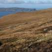
On-line Digital Images |
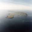
SC 1694463 |
RCAHMS Aerial Photography |
General oblique aerial view of Rum (Rhum) looking ESE from SW corner of Canna (An Steidh). |
2/9/1994 |
Item Level |
|
 |
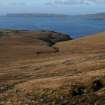
On-line Digital Images |
SC 1694464 |
RCAHMS Aerial Photography |
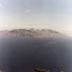
General oblique aerial view of Sanday and S part of Canna, looking ESE towards Rum (Rhum). |
2/9/1994 |
Item Level |
|
 |
On-line Digital Images |
SC 1694475 |
RCAHMS Aerial Photography |
General oblique aerial view of Sanday and SE coast of Canna looking ESE towards Rum (Rhum). |
2/9/1994 |
Item Level |
|
 |
On-line Digital Images |
SC 1694477 |
RCAHMS Aerial Photography |
Canna and Sanday: general aerial view from E. |
2/9/1994 |
Item Level |
|
 |
On-line Digital Images |
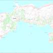
SC 1916986 |
Records of the Royal Commission on the Ancient and Historical Monuments of Scotland (RCAHMS), Edinbu |
Map of the archaeology of Canna and Sanday, created for Canna: the archaeology of a Hebridean landscape, RCAHMS Broadsheet 5, 1999 |
1999 |
Item Level |
|
 |
On-line Digital Images |
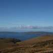
DP 384221 |
Records of the Royal Commission on the Ancient and Historical Monuments of Scotland (RCAHMS), Edinbu |
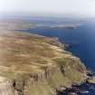
General view to Canna and Sanday from NW Rum. |
16/10/2010 |
Item Level |
|
 |
On-line Digital Images |
DP 384222 |
Records of the Royal Commission on the Ancient and Historical Monuments of Scotland (RCAHMS), Edinbu |
General view to Canna and Sanday from NW Rum. |
16/10/2010 |
Item Level |
|
 |
On-line Digital Images |
DP 384223 |
Records of the Royal Commission on the Ancient and Historical Monuments of Scotland (RCAHMS), Edinbu |
General view to Canna and Sanday from NW Rum. |
16/10/2010 |
Item Level |
|
 |
On-line Digital Images |
DP 384224 |
Records of the Royal Commission on the Ancient and Historical Monuments of Scotland (RCAHMS), Edinbu |
General view to Canna and Sanday from NW Rum. |
16/10/2010 |
Item Level |
|
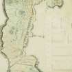 |
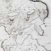
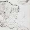
On-line Digital Images |
SC 2562040 |
Records of the Royal Commission on the Ancient and Historical Monuments of Scotland (RCAHMS), Edinbu |
Estate map of centre port by William Bald, 1805. |
|
Item Level |
|
 |
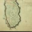
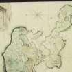
On-line Digital Images |
SC 2562041 |
Records of the Royal Commission on the Ancient and Historical Monuments of Scotland (RCAHMS), Edinbu |
Estate map of the West port by William Bald, 1805. |
|
Item Level |
|
 |
On-line Digital Images |
SC 2562042 |
Records of the Royal Commission on the Ancient and Historical Monuments of Scotland (RCAHMS), Edinbu |
Estate map of West port by William Bald, 1805. |
|
Item Level |
|
 |
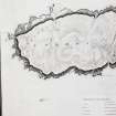
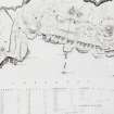
On-line Digital Images |
SC 2562043 |
Records of the Royal Commission on the Ancient and Historical Monuments of Scotland (RCAHMS), Edinbu |
Estate map by William Bald, 1805. Detail of harbour area. |
|
Item Level |
|
 |
On-line Digital Images |
SC 2562359 |
Records of the Royal Commission on the Ancient and Historical Monuments of Scotland (RCAHMS), Edinbu |
Estate map by William Bald, 1805. Detail of harbour area. |
|
Item Level |
|
 |
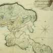
On-line Digital Images |
SC 2562494 |
Records of the Royal Commission on the Ancient and Historical Monuments of Scotland (RCAHMS), Edinbu |
Estate map of the East port by William Bald, 1805. |
|
Item Level |
|
 |
On-line Digital Images |
SC 2562495 |
Records of the Royal Commission on the Ancient and Historical Monuments of Scotland (RCAHMS), Edinbu |
Estate map of the East port by William Bald, 1805. |
|
Item Level |
|
 |
On-line Digital Images |
SC 2562496 |
Records of the Royal Commission on the Ancient and Historical Monuments of Scotland (RCAHMS), Edinbu |
Estate map of the centre port by William Bald, 1805. |
|
Item Level |
|


