
Sanday, Rubha Nan Feannag


Structure(S) (Period Unassigned)
Site Name Sanday, Rubha Nan Feannag
Classification Structure(S) (Period Unassigned)
Alternative Name(s) Canna
Canmore ID 137784
Site Number NG20SE 68
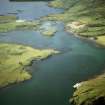
NGR NG 2739 0499
NGR Description NG 2739 0499 and NG 2737 0498
Datum OSGB36 - NGR
Permalink http://canmore.org.uk/site/137784


- Council Highland
- Parish Small Isles
- Former Region Highland
- Former District Lochaber
- Former County Inverness-shire
NG20SE 68 2739 0499 and 2737 0498
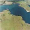
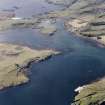
The grass-grown remains of two structures lie on Rubha nan Feannag, the headland on the W side of the part of Canna Harbour that does not dry out at low water. The larger (NG 2739 0499 ) is almost square on plan but is open on its N side measuring about 8m across from NNE to SSW; what appears to be a drainage channel around its E, S and W sides may in fact be a robber trench. The second structure (NG 2737 0498) lies immediately to the SW, and comprises little more than a narrow groove 5m long flanked on both sides by a low upcast earthen bank.
(Canna 83-4).
Visited by RCAHMS (ARG), 8 March 1996.
Field Visit (8 March 1996)
The grass-grown remains of two structures lie on Rubha nan Feannag, the headland on the W side of the part of Canna Harbour that does not dry out at low water. The larger (NG 2739 0499 ) is almost square on plan but is open on its N side measuring about 8m across from NNE to SSW; what appears to be a drainage channel around its E, S and W sides may in fact be a robber trench. The second structure (NG 2737 0498) lies immediately to the SW, and comprises little more than a narrow groove 5m long flanked on both sides by a low upcast earthen bank.
(Canna 83-4).
Visited by RCAHMS (ARG), 8 March 1996.

