
Pricing Change
New pricing for orders of material from this site will come into place shortly. Charges for supply of digital images, digitisation on demand, prints and licensing will be altered.
Cnoc An Duin


Fort (Prehistoric)
Site Name Cnoc An Duin
Classification Fort (Prehistoric)
Canmore ID 13710
Site Number NH67NE 1
NGR NH 6968 7687
Datum OSGB36 - NGR
Permalink http://canmore.org.uk/site/13710


- Council Highland
- Parish Logie Easter
- Former Region Highland
- Former District Ross And Cromarty
- Former County Ross And Cromarty
NH67NE 1 6968 7687.
(NH 6968 7687) Fort (NR) (unfinished)
OS 6" map, (1969)
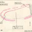
An unfinished fort enclosing a near-level area measuring approximately 220.0m E-W by 80.0m, on the summit of a hill named Cnoc an Duin. The defences comprise a partly-constructed inner wall, and an outer work, mainly visible as a discontinuous terrace. There is no evidence of artificial construction in the E, where a steep rocky gully provides a natural defence. No marker trenches, as observed in other unfinished forts, can be seen.
The wall extends from just S of the entrance in the W, along the N edge of the summit to the gully in the E, protecting the easiest approach, and of this, only about 90.0m, immediately E of the entrance, shows signs of completion, surviving to a maximum height of 1.2m. Elsewhere, gaps in the tumble suggest that the wall was being built in sections about 20.0m long. Inner and outer facing stones are visible intermittently indicating a wall thickness of c. 2.6m at the E end, increasing to c. 3.8m at the entrance. The footings of the outer face continue unbroken across the entrance forming a threshold. The N side of the entrance is c. 1.0m high, but there is no evidence of the S side in tumble, which extends S for c. 14.0m before petering out. A gap of c. 5.0m towards the E end of the wall may be another entrance, as the last 20.0m of the wall to the E is offset.
The outer terrace around the N, W and S flanks of the hill is constructed by scraping into the slope, with the excavated material thrown outwards. There are a number of quarry scoops, mainly on the line of the terrace, but also above and below it. The entrance is in the W, coincident with that in the inner wall, and for 20.0m to the N of it, material from quarry scoops, including much stone, has been piled on the outer lip of the terrace to form a rampart c. 5.0m wide. A break in the terrace near its NE end on the E gully may be an entrance.
Except for a hollow, 0.7m in diameter, with a modern dry-stone surround on the highest point of the hill, alleged to be a well, the interior is featureless.
ISSFC 1902; R W Feachem 1963; Visited by OS (N K B) 2 November 1970.
This unfinished fort occupies a promontory at the west end of a ridge of this name which overlooks the left bank of the Strathrory river, in Ross and Cromarty. The line to be followed by the proposed inner defence, a stone rampart, was clearly indicated by the well-defined margin of the promontory which forms a natural marker. When construction work ceased a bank of stones about 3.0m wide had been piled up along a little under half the perimeter of the proposed fort. On the west, where a start had been made on actually building the wall or rampart on either side of an entrance, there remains a continuous line of built outer face 53.4m in length, the lowest course of which runs across the entrance to form a doorstep. The parallel inner face is interrupted at the entrance by a gap 1.8m wide. On the north side of the entrance the built faces of the wall, now collapsed inwards over the core, reach eight courses in height, but on the south side, as far as their termination, only two courses. From these remains and those on Little Conval NJ23NE 1) it would appear that walls of this kind were built by first gathering a certain amount of stones along the chosen line, then building the foundations of the wall-faces, and finally gathering or quarrying more stones to increase the height of the faces and the core to the desired limit.
R W Feachem 1971.
Field Visit (2 July 1958)
Fort, Cnoc An Duin.
The hill named Cnoc an Duin, which attains a height of904 feet above sea level, rises steeply for 450 feet from the left bank of the Balnagown River where this runs through Strathrory on its way to enter the Cromarty Firth at Nigg Bay, six miles to the ESE. The hill commands most of Strathrory into which it protrudes from the massif immediately to the N, and at the same time dominates the Glen of Scotsburn and Glen Aldie through which the Aldie Water flows to Tain and the Dornoch Firth.
The summit of the hill consists of a comparatively flat oval area measuring about 730 feet from E to W by about 250 feet transversely. The flanks of the hill slope steeply down from this to S and W towards the river, but to the N there is a more gentle descent of less than 50 feet .to a narrow marshy valley which connects Cnoc an Duin to the massif beyond. To the E however the summit plateau is cut off from the neighbouring part of the bill by a steep-sided rocky gorge of striking appearance which runs from N to S to form a gash a quarter of a mile in length and up to 150 feet in breadth thus effectively isolating the part of the summit just described.
The construction of a hill fort was begun, but not completed, on the summit plateau which, cut off by the gorge, formed a natural defensive promontory. The inner line was evidently to consist of a stone wall10 feet in thickness, for starting near the brink of the S lip of the natural gorge a substantial line of boulders runs W along the N margin of the summit plateau for a distance of 770 feet to terminate near the S extremity. For the most part the line of boulders appears as a heavy mass of tumbled blocks and slabs which is spread to a width of about 10 feet or12 feet., the edges of the mass appearing to be overlain in places by peat. The westernmost stretch, 170 feet in length, has several interesting characteristics. The amount of stones in this sector appears to be greater than that visible further E, while stretches of built faces begin to be visible above the heather at irregular intervals on either side of the mass of boulders. Some sections of faces up to eight courses in height can be seen but in all cases these have fallen backwards to a greater or lesser degree into the loose rubble at their rear which formed the core of the wall. At a point 40 feet from the termination of the line of the boulders there is a ruinous but clearly perceptible transverse face which runs across to unite the inner and outer faces. Beyond this the lowest course of the outer face can be seen to continue without interruption all the way to the end; that of the inner face only resumes after a gap of about 5 feet, but thereafter it too runs to the end, It is notable that from the transverse face to the end the wall consists of an inner and an outer face of one or two courses in height between which are placed enough boulders to fill in the space but not to form a pile or to rise above the low faces. There can be no doubt that this final. stretch of 40 feet represents an early stage in the construction of the wall, and that the proceeding was apparently first to lay the lower course of the facing stones at the required distance apart, then to fill in the space between them with boulders, and so to erect the wall, in the form of built faces with a rubble core, on the foundation thus prepared. It is remarkable that, when the embryo wall ends abruptly at the W end of the summit plateau, the course it would presumably have proceeded to follow along the S edge of the plateau is not marked out either by a marker trench (Little Conval) or by a rickle of stones (Durn Hill). It is possible that perishable objects such as wooden pegs were used in this case.
Apart from the cross-face in the NW arc of the wall which has been described above, the only other gap in the line of boulders is near the E end. The line springs from near the lip of the natural gorge, as already mentioned, but after a distance of only 60 feet in a straight line the boulders cease. There ensues a gap of some 20 feet, on the far side of which the boulder line resumes at a different angle. It is possible that the gap was designed to form the basis of a main entrance but the alignment of the wall on either side of it cannot readily be explained.
The outer line of defence also appears in an incomplete form. It consists in essence of a linear excavation designed to follow the wall, or the crest of the summit plateau, at a distance varying from 40 feet to 70 feet. At no place was it advanced to a stage nearing completion, but sufficient work exists to show that the final spoil was to be thrown outside the ditch or terrace and that the larger boulders were being collected above the inner lip. . All along the N flank of the hill, from the lip of the gorge for a distance of about 800 feet, this line of defence appears merely as a shallow terrace dimly perceived in the long and deep heather. There are several minor interruptions along it, and two major ones but most if not all these probably represent the boundaries between the work of different gangs. At the end of this stretch the line begins to turn through SW to S, and thereafter for almost its entire length it is not only free from heather but runs along the steeper flanks of the hill. A gap in the S arc covers the place in the inner line of boulders where the transverse face crosses it. The gap consists of a causeway in the excavated ditch or terrace some 12 feet in width, the N side of it being well-defined because an attempt has been made to collect stones and boulders and to form them into a line of transverse facing about 15 feet in length. This spans the end of the excavation and likewise forms a termination to the outer line of gathered stones, and may even have run on to the inner line. It is now so ruinous, however, that no precise description can be given. Beyond the the excavation and the collections of boulders and rubble both above below it continue round the SW and S faces of the hill. Traces of gang work appear all along it, and for a considerable stretch the excavation cannot be traced at all. In the last 200 feet before the gorge is reached again the stones and rubble collected outside the excavation begin to form a low mound while the amount of boulders on the inner side increases. Just before meeting the lip of the gorge the outer defence is again covered with long heather, but it is probable that the outer mound turns up to the N to terminate on the lip of the gorge. There is nothing to show that there was ever any defensive line on the crest of the gorge.
The interior is covered with peat and heather, and the only definite feature visible within it is what appear-s to have been a small water-hole. The hole, about 2 feet in diameter, was choked with stones at a depth of 2 feet and dry on the day of visit. It occupies the bottom of a shallow depression itself about 2 feet deep and 10 feet in width in which a penannular wall one course thick stands to a height of 4 feet. The wall is probably of no great age.
NH 696 769, OS Map ilv
Visited by RCAHMS 3 July 1958
Field Visit (November 1977)
Cnoc an Duin NH 696 768 NH67NE 1
This unfinished fort occupies the summit of Cnoc an Duin. The defences, which would have enclosed an area measuring about 220m by 80m, comprise an inner wall and what was probably intended to be an outer rampart.
RCAHMS 1979, visited November 1977
(Transactions of the Inverness Scientific Society and Field Club, v 1895-9), 362; Feachem 1971, 28-9;1977 14Q)
Note (13 March 2015 - 18 May 2016)
This fort displays some of the clearest evidence of its unfinished character to be found anywhere in Scotland. Occupying the crest of a steep-sided ridge towering above the river on the N side of Strath Rory, its unfinished defences comprise two elements: firstly a wall that was evidently intended to enclose the summit area of the ridge extending westwards from a precipitous cleft across its axis; and secondly a more ragged outer line contouring between 15m and 20m outside it. The inner wall, which was never begun along the S flank, displays a remarkable progression around the N flank, from 1.2m high and complete with wall core faced inside and out to a maximum thickness of 3.8m adjacent to the entrance on the W, to a sector where the facing blocks had been put in place without the full height of core and are now cowped backwards like stacked dominoes onto a layer of rubble, and finally tailing off into to the eastern sector where no more than a rough and intermittent band of rubble marks its course. The area to be enclosed measures about 220m from ENE to WSW by 80m transversely (1.6ha) and there may have been a second entrance at the E end of the N side. The outer line is of rather different character, comprising rubble pile crudely in places along the leading edge of a quarried terrace that has been cut back irregularly into the slope, but unlike the inner, this can also be traced along the S flank of the hill, turning sharply back at the W end no more than 10m outside the inner line. It too has an entrance at the W end, and possibly another opposite the gap in the inner at the E end. Nevertheless, the lines are sufficiently eccentric to each other that it is possible that they are not contemporary, in which case the continuous outer circuit suggests that it is the earlier, enclosing an area of about 2.2ha. The interior is rough and peat covered and generally obscured by deep heather.
Information from An Atlas of Hillforts of Great Britain and Ireland – 18 May 2016. Atlas of Hillforts SC2899

