
Pricing Change
New pricing for orders of material from this site will come into place shortly. Charges for supply of digital images, digitisation on demand, prints and licensing will be altered.
Kinbeachie Castle


Castle (Medieval)
Site Name Kinbeachie Castle
Classification Castle (Medieval)
Canmore ID 13705
Site Number NH66SW 5
NGR NH 63436 62186
Datum OSGB36 - NGR
Permalink http://canmore.org.uk/site/13705


- Council Highland
- Parish Resolis
- Former Region Highland
- Former District Ross And Cromarty
- Former County Ross And Cromarty
NH66SW 5 6343 6218.
(NH 6343 6218) Kinbeachie Castle (NR)
OS 6" map, (1959)
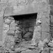
Of Kinbeachie Castle, formerly a seat of the Urquharts, only the south gable remains. It contains a fireplace over which is a panel dated 1546. The other walls are reduced to foundation level.
MacDonald, Polson and Brown (1931) say that another panel, dated 1612, is now in the National Portrait Gallery, Edinburgh.
Name Book 1875; D MacDonald, A Polson and J Brown 1931.
The remains of Kinbeachie Castle comprise the SE wall and the foundations of the NE, NW and SW walls. The SE wall, 1.2m in width; is extant to a maximum height of 1.7m and the total length is 6.6m externally. It is rubble masonry, but the E and S angles have been constructed of dressed stones. The inside face of the wall is obscured in a mass of tumble, and the fireplace, together with the date panel, is no longer visible.
Revised at 1/2500.
Visited by OS (R B) 24 January 1966.
No remains.
RCAHMS 1979.
Demolished 1959
Photographic Survey (September 1959)
Photographic survey of Kinbeachie Castle, Ross and Cromarty, by the Scottish Nationa Buildings Record in 1959.
Field Visit (1979)
Kinbeachie Castle NH 634 621 NH66SW 5
Nothing can now be seen of this tower-house which was demolished in 1959. It bore a datestone of 1546.
RCAHMS 1979, visited May 1979
Photographs in NMRS
Field Visit (1 March 2017 - 30 May 2017)
NH 6339 6218 (farmstead), NH 6343 6218 (site of Laird’s House – previously recorded as castle) and NH 6340 6220 (castle) A programme of archaeological work was undertaken, 1 March – 30 May 2017, on the site known as Kinbeachie Castle, which consists of a collection of grassy humps and bumps covering c70 x 60m in the corner of a field. The physical remains are confusing when compared with descriptions and interpretations on the Canmore and Highland HER databases. The site is marked as ‘Kinbeachie Castle’ on the OS maps and local knowledge, previous interpretations, and a carved stone with the date of 1546 above a fireplace on a photograph of 1959 concur with this interpretation. However, photographs taken by the RCAHMS in 1959 clearly indicate the gable end of an 18th-century ‘laird’s house’; and documentary information and an 18th-century map, providing evidence of a laird’s house at Kinbeachie also exist. The site consists of two parts:
The central area – The N part of this area has the substantial turf covered footings of two walls at right angles to one another; they are 10.5m and 7–8m in length, between 0.6–1m high and have a spread of 2–4m. To the S two linear mounds terminate in several amorphous stone settings. These remains in no way resemble the 1959 photographs or the footings described in the 1966 Canmore entry of the castle.
The W and S part of the site has the turf covered footings of the several buildings which make up the farmstead. Also associated with the farmstead is the raised circular platform of a horse gang and a large D-shaped enclosure, 50 x 25m, bounded on its S side by a sloping bank which has evidence of stone facing in places.
After carefully studying the remains in conjunction with the documentary, photographic, map and oral evidence it was possible to arrive at a confident conclusion. There has been significant destruction and stone robbing at the site, but there is, or has been, the remains of both a castle and a ‘laird’s house’ in addition to the later farmstead at the Kinbeachie site:
The buildings of the farmstead (Canmore ID: 13700 centred on NH 6339 6218) are clearly in the position of the roofed buildings on the early OS maps.
The footings of the ‘laird’s house’ were previously recorded as the castle (Canmore ID: 13705, centred on NH 6343 6218) and were still extant in 1966 when they were described by the RCAHMS, but they have disappeared completely with the area being ploughed out. The building was on rising ground to the E of the present remains and is shown as a ruin on the 1st and 2nd Edition OS maps (1876 and 1904) and also the 1937–60 map, nothing is shown on the current OS map. Study of the background context of the 1959 photographs and the previously recorded NGRs confirm this interpretation.
We are left with the substantial remains in the central area of the site centred on NH 6340 6220. These must surely be what remains of the old castle, much altered and almost certainly reused as a byre. The two walls at right angles suggest the foundations of a small medieval tower house, c10.5 x 7–8m in plan, very similar in size to others in the district; the ‘expanded’ corner is intriguing – was it a stair turret?
Archive: Highland Council Archives (intended). Report: Highland Council HER and NOSAS website
Meryl Marshall – North of Scotland Archaeological Society
(Source: DES, Volume 18)

