
Pricing Change
New pricing for orders of material from this site will come into place shortly. Charges for supply of digital images, digitisation on demand, prints and licensing will be altered.
Evanton Airfield


Airfield (20th Century)
Site Name Evanton Airfield
Classification Airfield (20th Century)
Alternative Name(s) Novar Camp
Canmore ID 13678
Site Number NH66NW 34
NGR NH 6244 6639
NGR Description Centred on NH 6244 6639
Datum OSGB36 - NGR
Permalink http://canmore.org.uk/site/13678


- Council Highland
- Parish Kiltearn
- Former Region Highland
- Former District Ross And Cromarty
- Former County Ross And Cromarty
NH66NW 34.00 centred 6244 6639
See also NO43SW 88.
NH66NW 34.01 Centred NH 6215 6673 Hangars; Buildings; Huts
NH66NW 34.02 Centred NH 6200 6700 Buildings; Nissen Huts; Huts
NH66NW 34.03 Centred NH 6263 6755 Hangars; Buildings; Nissen Huts
NH66NW 34.04 Centred NH 6253 6778 Military Camp
NH66NW 34.05 Centred NH 6186 6760 Military Camp
NH66NW 34.06 Centred NH 6261 6708 Hangars; Buildings; Nissen Huts;
NH66NW 34.07 NH 62785 66830 Pillbox
NH66NW 34.08 NH 62829 66554 Pillbox
NH66NW 34.09 Centred NH 6200 6675 Houses; Buildings; Huts
NH66NW 34.10 Centred NH 6170 6640 Bomb Store
NH66NW 34.11 NH 60600 65664 Pillbox
NH66NW 34.12 NH 61918 67247 Pillbox
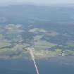
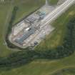
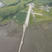
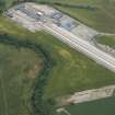
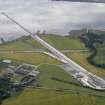
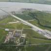
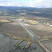
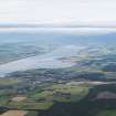
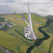
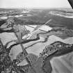
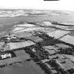
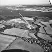
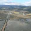
The main part of Evanton Airfield is situated to the S of a new stretch of the A9 improvement scheme which has itself destroyed many of the ancillery buildings and accommodation camps. Immediately to the S of the new stretch of road is a small industrial estate in which many of the large hangars have survived (NH66NW 34.01) due to their re-use by a number of local industries. Several of the hangars are now derelict and are being allowed to deteriorate, some with the large sliding doors removed.
Airfield buildings are noted in three main areas two to the S of the A9 and one to the N. Little remains of the accommodation areas which are seen on vertical air photographs (RAF 106G/Scot/UK 114, 3097-3100, flown 1946)
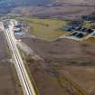
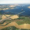
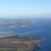
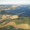
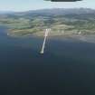
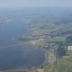
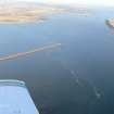
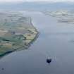
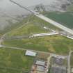
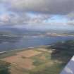
Two pillboxes, one of which has a pitched roof, stand on the E side of the runways on a bank beyond a large drain adjacent to the coastline. The runways have survived, however, and one now has been partly built over by an oil pipeline construction frame which has been extended to run on to a causeway running out into the Cromarty Firth. Much of the land between the runways has reverted to farmland. The E-W runway is 1248 yds long and the NE-SW is 1002 yards long.
The airfield was spread over a large area and incorporated many of the aspects of RAF and RN ownership including bomb stores, accommodation, repairs, stores and motor transport buildings, few of these survive, though some elements can be detected in the four main groups of buildings.
A good plan of the airfield is held in the Public Record Office in Kew, London.
Visited by RCAHMS (DE) January and May 1997.
Airfield; Novar camp - stable condition.
Accreting next to piers in I.T. zone, pier eroding.
Piers/quays constructed of old airfield buildings perhaps lumps of brick, concrete, metal rods etc.
CFA/MORA Coastal Assessment Survey 1998.
This airfield is siuated on both sides of the new A9 (T) road. Runways, hangars and many other buildings are extant. The airfield was known as Novar during World War I.
J Guy 2000; NMRS MS 810/10, Vol.2, 111, Vol.3, 35-6

