
Belle Port, Pier


Pier (Period Unassigned)
Site Name Belle Port, Pier
Classification Pier (Period Unassigned)
Alternative Name(s) Belleport Pier; Alness Belle Port; Dalmore Distillery; Cromarty Firth; Firth Of Cromarty
Canmore ID 13637
Site Number NH66NE 30
NGR NH 67322 68892
Datum OSGB36 - NGR
Permalink http://canmore.org.uk/site/13637


- Council Highland
- Parish Rosskeen
- Former Region Highland
- Former District Ross And Cromarty
- Former County Ross And Cromarty
NH66NE 30 67322 68892
Belleport Pier [NAT]
OS 1:10,000 map, 1992.
Not to be confused with landing-place at Alnessferry (on the Black Isle, at NH 66 66), for which see NH66NE 37.
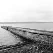
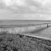
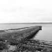
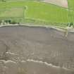
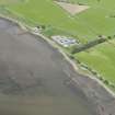
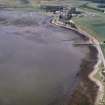
(Location cited as NH 673 688). Belleport Pier, built c. 1850 for timber shipment. A beautifully straight coursed-rubble pier.
J R Hume 1977.
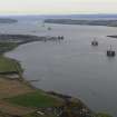
(Location cited as NH 690 673). Alness Belle Port: the B817 road comes right down to the shore of the Cromarty Firth immediately to the E of the delta of the Alness River [NH c. 65 67], a quarter of a mile (402m) before reaching Belle Port pier. This survives complete, though the top surface is grassed. Both sides curve neatly out from the shore, and are slightly battered up to a rolled edge kerb which is continuous round the sea end. The corners of the sea end are mitred. One very large iron ring is in place near each corner. Steps descending seawards are inset in the W side near the sea end, and near the shore on the E side.
A Graham and J Gordon 1988.
Jetty extending into the Cromarty Firth. Possibly associated with the nearby Dalmore distillery (NH66NE 23).
J Wordsworth, SSSIs, Scottish Natural Heritage, 1993.
Jetty / pier - seen , wind erosion.
CFA/MORA Coastal Assessment Survey 1998.
NH66NE 30 67322 68892
A course-rubble pier, built in c.1850's.
J R Hume 1977

