|
Photographs and Off-line Digital Images |
RC 5081 PO |
Papers of Professor John R Hume, economic and industrial historian, Glasgow, Scotland |
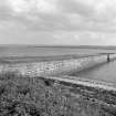
View looking South East |
1974 |
Item Level |
|
 |
On-line Digital Images |
SC 435166 |
Papers of Professor John R Hume, economic and industrial historian, Glasgow, Scotland |
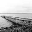
Belleport, Pier
View looking SE towards Ferryton |
1974 |
Item Level |
|
|
Manuscripts |
MS 726/167 |
Records of CFA Archaeology Ltd, archaeologists, Musselburgh, East Lothian, Scotland |
Coastal Assessment Survey: Inner Moray Firth, Volumes 1 and 2. |
14/12/1998 |
Item Level |
|
 |
On-line Digital Images |
SC 498682 |
Papers of Professor John R Hume, economic and industrial historian, Glasgow, Scotland |
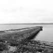
Bellport Pier
View from N showing ENE front |
30/5/1976 |
Item Level |
|
 |
On-line Digital Images |
SC 498683 |
Papers of Professor John R Hume, economic and industrial historian, Glasgow, Scotland |
Bellport Pier
View from NW showing WSW front |
30/5/1976 |
Item Level |
|
|
Manuscripts |
MS 749/2837 |
Papers of Professor John R Hume, economic and industrial historian, Glasgow, Scotland |
John R Hume Industrial/CBA cards
Filed under Ross and Cromarty, Rosskeen parish. Contact prints attached (Hume photo index number H76/154/7, 8).
(see NMRS MS/749 entry for Collection description) |
30/5/1976 |
Item Level |
|
|
Manuscripts |
MS 2776/1/11 |
Historic Scotland Archive Project |
Survey archive: Site record sheets, site record sheets with field notes and monument forms from the Inner Moray Firth (Moray, Beauly and Cromarty Firth) Coastal Assessment Survey. Sheet 11. |
9/1998 |
Item Level |
|
|
Prints and Drawings |
BD 104/1/11 |
Historic Scotland Archive Project |
Survey archive: 1:25,000 OS Pathfinder map depicting site locations from the Moray, Beauly and Cromarty Firth Coastal Assessment Survey. Sheet 11. |
9/1998 |
Item Level |
|
 |
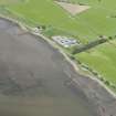
On-line Digital Images |
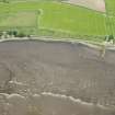
DP 191673 |
RCAHMS Aerial Photography Digital |
Oblique aerial view of the fish traps and pier, looking NW. |
18/6/2014 |
Item Level |
|
 |
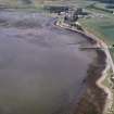
On-line Digital Images |
DP 191677 |
RCAHMS Aerial Photography Digital |
Oblique aerial view of the fish nets, looking NW. |
18/6/2014 |
Item Level |
|
|
Photographs and Off-line Digital Images |
J 11966 CS |
Papers of Professor Geraint Dyfed Barri Jones, archaeologist, Manchester, England |
Oblique aerial view |
7/7/1992 |
Item Level |
|
 |
On-line Digital Images |
SC 1590209 |
Papers of Professor Geraint Dyfed Barri Jones, archaeologist, Manchester, England |
Oblique aerial view |
7/7/1992 |
Item Level |
|
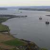 |
On-line Digital Images |
DP 342334 |
Papers of James Sloan Bone, landscape historian, Inverness, Highland, Scotland |
Aerial view of Cromarty Firth, looking E. |
7/11/2010 |
Item Level |
|
 |
On-line Digital Images |
SC 2364579 |
Records of the Ordnance Survey, Southampton, Hampshire, England |
Belle Port, Pier, NH66NE 30, Ordnance Survey index card, Recto |
c. 1958 |
Item Level |
|


