Pricing Change
New pricing for orders of material from this site will come into place shortly. Charges for supply of digital images, digitisation on demand, prints and licensing will be altered.
James's Temple
Dun (Prehistoric)
Site Name James's Temple
Classification Dun (Prehistoric)
Alternative Name(s) Drumderfit Hill; Culnacraigh
Canmore ID 13593
Site Number NH65SE 6
NGR NH 66025 52188
Datum OSGB36 - NGR
Permalink http://canmore.org.uk/site/13593
- Council Highland
- Parish Knockbain
- Former Region Highland
- Former District Ross And Cromarty
- Former County Ross And Cromarty
NH65SE 6 6601 5218
(NH 6601 5218) James's Temple (NAT)
Dun (NR)
OS 6" map, (1959)
Henshall (1963) and Feachem (Information from R W Feachem to OS, 1958) agree that this is a small dun, although Woodham (1956) interpreted the site as a long cairn. Besides the stones shown on the plan, a great quantity of stone is scattered down the steep slope on the N, and large slabs and smaller stones are scattered around the summit.
A A Woodham 1956; A S Henshall 1963, visited 1956.
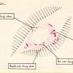
James's Temple, the scant remains of a dun, overgrown with broom, on a spur on the NE shoulder of Drumderfit Hill. It is oval on plan, measuring overall about 17.0m NE-SW by about 11.0m. The denuded wall is turf-covered and spread to c. 3.5m at the easiest approaches in the NE and SW, c. 2.5m in the SE, and is reduced to a faint rickle of stones in the NW where it has fallen down the slope. Six inner facing stones on edge survive in the S arc; four blocks up to 1.0m high, three in the NE and one in the SW, are outer facing stones, and several smaller stones in the S and NW may represent others. Several blocks of the outer face lie displaced outside the dun. The entrance in the ENE is flanked at its outer end by two blocks on edge indicating a width of 1.0m. Another prostrate block within the entrance has once flanked its S side.
Revised at 1/2500 (OS {N K B} 21 March 1966.
Visited by OS (N K B), 21 March 1966 and 3 December 1970.
Field Visit (June 1979)
James's Temple, Drumderfit NH 660 521 NH65SE 6
On a prominent spur on the NE shoulder of Drumderfit Hill there are the heavily overgrown remains of a dun measuring 13.4m by about 8.3m within a wall spread to a thickness of up to 3.6m; the entrance is on the NNE.
RCAHMS 1979, visited June 1979


