
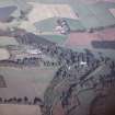
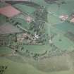
Arbuthnott House, Designed Landscape


Park (Period Unassigned)
Site Name Arbuthnott House, Designed Landscape
Classification Park (Period Unassigned)
Alternative Name(s) Arbuthnott House Policies
Canmore ID 135467
Site Number NO77NE 2.01
NGR NO 7951 7505
Datum OSGB36 - NGR
Permalink http://canmore.org.uk/site/135467


- Council Aberdeenshire
- Parish Arbuthnott
- Former Region Grampian
- Former District Kincardine And Deeside
- Former County Kincardineshire
Field Visit (8 June 1998)
NO77NE 2.01 centred 7951 7505
Elements of the designed landscape in the grounds of Arbuthnott House were recorded during a pre-afforestation survey by Headland Archaeology (NMRS MS 899/90, no.4). The designed landscape comprises regular fields, shelter belts, avenues and formal gardens. In particular, a tree-lined avenue (NO77NE 70) forming the extension of the Dark Avenue W towards the main road was noted within a narrow strip of mature woodland. The beech trees on either side of the drive are clearly of some age and were probably planted during the development of the formal layout of the grounds.
T Holden and C Lowe (Headland Archaeology) 8 June 1998; NMRS MS 899/90, no. 4

