
Torr An Daimh


Building (Period Unknown)(Possible), Cairnfield (Prehistoric), Field System (Prehistoric), Hut Circle(S) (Prehistoric)
Site Name Torr An Daimh
Classification Building (Period Unknown)(Possible), Cairnfield (Prehistoric), Field System (Prehistoric), Hut Circle(S) (Prehistoric)
Canmore ID 13287
Site Number NH63SW 52
NGR NH 604 311
NGR Description Centred at NH 604 311
Datum OSGB36 - NGR
Permalink http://canmore.org.uk/site/13287


- Council Highland
- Parish Dores
- Former Region Highland
- Former District Inverness
- Former County Inverness-shire
Field Visit (20 February 1970)
NH63SW 52 604 311.
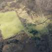
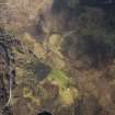
Centred at NH 604 311 on the generally S-facing slopes of a hill named Torr an Daimh, is a settlement of four stone-walled huts (A - D) and an associated field system.
Huts A, B, and C are oval, each with an entrance in the E through the longer axis, and D, the best preserved, is circular, also with an entrance in the E arc.
Hut 'A', built up on an E-facing slope, measures c. 12.5m E-W by c. 11.0m N-S between the centres of a wall spread to c. 2.5m on the upper W arc, increasing to c. 3.5m at the ill-defined entrance in the lower E arc. This increase in width is due to build-up, rather than a "clubbed" entrance. Part of the outer face of contiguous stones is visible around the N and W arcs.
Huts 'B' and 'C' are identical except the 'B' has an excavation in its centre. Each measures c. 13.5m E-W by c. 12.5m between the centres of a wall spread to c. 3.5m all round, with a splayed entrance measuring 1.5m wide internally, increasing to c. 3.0m externally. Some 5.0m to the NW of 'B' are the footings of a later rectangular building, measuring 11.0m x 5.0m. A track skirts the NW side of hut 'C'.
'D' is 10.4m in diameter within a double wall with rubble core. Both inner and outer faces of contiguous stones set on edge are visible for most of the periphery giving a wall thickness of 1.3m all round. On the N side the hut wall incorporates a boulder which extends through the whole width of the wall. The entrance, c. 1.4m wide, is obscured by tumbled stone, but does not appear to be splayed. Flanking the inner side are two blocks, possibly portal stones, though the N one may not be in situ. A field wall extends from the W arc.
The field system comprises field walls, lynchets, and stone clearance heaps forming cultivation plots, one of which, between huts 'C' and 'D', measures 35.0m x 20.0m. The walls occur predominantly in the vicinity of hut 'D', suggesting that it is not contemporary with the others, although there is no obvious boundary between the areas of cultivation.
Visited by OS (N K B) 20 February 1970.
Field Visit (21 October 1992)
There are four hut-circles, a field-system, many small cairns, and a possible building on the S and W flanks of Torr an Daimh. With the exception of one hut-circle (USN93 154, OS 'D'), most of the structures were covered in deep heather on the date of visit, and, as a consequence, the possible building was not noted.
The hut-circles range from 9.8m to 11m in diameter within stony banks which, where well preserved, measure about 1.75m in thickness and 0.5m in height; elsewhere, they are spread to a thickness of up to 3.3m. The entrances are all on the E. The hut-circle on the W of the hill (USN93 154, OS 'D') abuts the wall of a roughly circular field measuring about 80m in diameter. Small cairns and short stretches of bank are visible on the flanks of the hill.
(USN93 151-4)
Visited by RCAHMS (PJD) 21 October 1992.

