
Caisteal An Dunriachaidh


Fort (Prehistoric)
Site Name Caisteal An Dunriachaidh
Classification Fort (Prehistoric)
Alternative Name(s) Ashie Moor; Achnabat
Canmore ID 13283
Site Number NH63SW 49
NGR NH 6005 3165
Datum OSGB36 - NGR
Permalink http://canmore.org.uk/site/13283


- Council Highland
- Parish Dores
- Former Region Highland
- Former District Inverness
- Former County Inverness-shire
NH63SW 49 6005 3165
(NH 6005 3165) Caisteal an Dunriachaidh (NAT)
Fort (NR) (Remains of)
OS 6" map, Inverness-shire, 2nd ed., (1905)
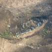
A fort, oval on plan, measuring 125' by 110' within a ruined stone wall some 10' thick, with an outer wall, at varying distances from it enclosing an area of 300' by 150'. Each wall has an entrance in the SW.
ISSFC 1885; R W Feachem 1963.
Caisteal an Dunriachaidh, a mutilated fort situated on an isolated ridge running NNE-SSW. It is protected in the E and SE by a cliff, and in the N and W by a rocky scarp, with the only easy access up an easy slope from the SW.
Feachem's (R W Feachem 1963) measurements cannot be verified as neither of the walls can be traced around the E side of the ridge. A quantity of tumble at the base of the cliff in the E, however, suggests that at least one of the walls originally formed a complete enclosure. Where best preserved in the SW, both walls are spread to c. 3.0m with the outer faces occasionally protruding through the tumble to a maximum height of 0.6m. No inner faces can be seen. The entrance through each wall in the SW, is partially blocked by tumble.
The defences have been supplemented in the NW at the base of the ridge by a ditch, and the spoil used to form an outer bank, now c. 0.6m high. Within the fort is a wet depression, possibly a cistern.
Surveyed at 1:10,000.
(Visible on OS air photographs 67/198/008)
Visited by OS (NKB) 2 March 1970.
Heather burning has revealed traces of another wall barring the access in the SW, some seven metres out from the second wall. Only three vague fragments survive, the most NW portion showing three outer facing stones.
Visited by OS (AA) 16 April 1974.
Scheduled as 'Caisteal an Dunriachaidh, fort 1520m N of Achnabat... the remains of a small fort... on a rocky ridge, at a height of 260m above sea level, rising from Ashie Moor between Loch Ness and Loch Duntelchaig.'
Information from Historic Scotland, scheduling document dated 16 July 2009.
Caisteal an Dunriachaidh
Fort (remains of) [NAT]
OS (GIS) MasterMap, August 2009.
Field Visit (19 August 1943)
Fort, Cairns etc, Caisteal an Dunriachchaidh.
This fort occupies an elongated boss of conglomerate which rises from the marshy moorland lying NW of Loch Dun an t-Seilchaig and SW of Loch nan Eoin Ruadha and Loch a’Choin. The major axis of this eminence runs from NE to SW; its SE side consists of a formidable precipice at least 50ft high and its NW side, though less uniformly precipitous, is steep and broken up by patches of sheer rock-face. The defences, which are very much dilapidated, consist of an inner and an outer rampart on the ridge itself while a mound of earth and stone, which it is difficult to regard otherwise than as part of the defensive system runs immediately below the base of the ridge on its NW side and fades out to the SW and the NE on rocky outcrops. (This mound is not shown on the plan). The outer rampart proper crosses the SW end of the ridge, where access is easy, and is here pierced by an entrance which, though clearly distinguishable, shows no definite features other than the outer corner on the NW side and a line of masonry 2ft 6in long marking the return face of the entrance passage. From the entrance the rampart swings E and NE with the contours to die out on the lip of the precipice at a distance of 100ft. On the other side of the entrance it swings similarly to the N and NE, becoming fragmentary towards the NE extremity of the ridge where again it appears to have ended on the precipitous eastern side. The thickness of the outer rampart is not measurable. There seems to have been no artificial defences along the lip of the precipice, and this and the outer rampart between then enclose an almond shaped area measuring 290ft from NE to SW by about 145ft (maximum) transversely. The inner rampart encloses part of the summit of the ridge; it can be traced from a point about 15ft NW of the end, on the lip of the precipice, of the SE section of the outer rampart, to west, north and east until it dies out on the side of a rocky knoll which is the highest part of the site. There is nothing to suggest that it ever extended along the SE side of the summit, above the precipice. The outer face of this wall is visible here and there to the extent of one or sometimes two courses, but its thickness is nowhere measurable and no entrance can be identified with certainty. There is a waterhole 10ft in diameter in the NE part of the enclosure between the inner and outer ramparts.
On the flat moorland to the south and west of the ridge on which the fort stands there are a number of small cairns [NS53SE 21]. On the SW there are traces of an enclosure or hut measuring 36ft by 20ft and of another of smaller size. More small cairns can be seen NW of the fort, on the west side of the road that runs NE towards Loch Ashie.
Visited by RCAHMS (AG) 19 August 1943.
OS ref: xxx
Field Visit (13 April 1957)
Fort, Ashie Moor.
This fort stands at a height of a little over 800 feet O. D. three quarters of a mile SE. by E. of Drummond house on a low rocky outcrop that protrudes from the marshy surface of Ashie Moor. The axis of the outcrop runs from NE. to SW., the long flanks presenting steep, rocky faces rising to a height of about 40 feet above the level of the ground below, that on the SE. being particularly steep. The fort is oval on plan and measures 125 feet in length from NE. to SW. by 110 feet transversely within a ruined stone wall. This surrounds the summit of the outcrop in the form of a broad band of blocks and stones that may represent the ruin of a wall some 10 feet in thickness. The E. section of this wall has either been robbed or has fallen away down the steep flank of the outcrop. A diminution of the volume of stone in the SW. arc suggests that the entrance was originally in this quarter. The ruin of an outer wall starts at a point on the lip of the SE. face of the outcrop distant about 20 feet S. of the inner wall, and then runs through S. to W. at a distance of about 40 feet from the latter. Instead of following it round through N. to return directly to the SE flank of the outcrop, however, it then runs on along the lip of the opposite flank, only turning through N. and dying out at the very extremity of the outcrop. This wall thus encloses an area measuring 300 feet in length by about 150 feet in breadth. There is a distinct entrance in the SW. arc. The general appearance of the ruins of this wall suggests that it may well have been contemporary with the inner one. A low mound of rubble runs on the moorland immediately below the base of the outcrop from a point a little NE. of the NE. extremity of the latter to W., SW. and S., finally dying out after a distance of some 450 feet near the SW. foot of the outcrop. This structure, which would add to the strength of the fort, is probably contemporary with it.
Visited by RCAHMS 13 April 1957.
Field Visit (22 October 1992)
This fort occupies a rocky ridge; a sheer cliff forms the E side and the only easy access is from the SW. The highest part of the ridge has probably been surrounded by a stone wall, of which only the W half survives, enclosing a roughly-circular area measuring about 30m in diameter. The wall is 3.8m thick and stands to a height of up to 2m; the entrance is on the SW. A second wall extends from the cliff-edge on the SE to take in a terrace below the inner wall and swings in a gentle arc to end on the top of the cliff on the NE. The remains of a third line of defence can be seen on the NW, where a ditch with an outer upcast bank flanks the base of the ridge; on the N it appears as a stony band rising up the side of the ridge to join the outer wall. On the date of visit deep heather obscured what may be the SW extension of this work, located by the OS, cutting across the back of the ridge.
(USN93 156)
Visited by RCAHMS (PJD) 22 October 1992.
Note (11 March 2015 - 31 May 2016)
This small fortification stands on a precipitous boss in open moorland on Ashie Moor. Comprising two eccentric enclosures, the inner on the summit is roughly circular on plan, measuring about 30m in diameter (0.07ha) within a thick wall that has largely collapsed over the edge of the cliff forming the ESE flank of the boss. Elsewhere it is reduced to a mound of rubble up to 3.8m thick, in which the line of the outer face is visible, in places standing 0.6m in height. This inner enclosure, however, lies eccentrically within an outer defence that is best preserved where it crosses the spine of the boss on the SSW, but can also be traced along the crest of the rocky NW flank to return to the cliff-edge on the other side on the NNE, thus enclosing an area measuring about 80m from NNE to SSW by 33m transversely (0.25ha); on the SW this wall is of a similar scale to the inner, again with its outer face visible amongst the rubble. The entrances through both walls lie on the SSW. Traces of a third wall were noted by Alan Ayre of the OS in 1974 after heather burning, following the leading edge of a terrace some 7m further down the slope on the SW, below which on the NW a ditch with an external bank has been cut into the foot of the slope along NW flank of the boss. The only features visible within the interior are a relatively modern shelter built into the innermost wall and a possible well, shown on the plan drawn up by Ayre within the summit enclosure, but in 1943 identified by Angus Graham between the inner and outer walls on the NNE. The relationship between the inner and outer enclosures is unknown.
Information from An Atlas of Hillforts of Great Britain and Ireland – 31 May 2016. Atlas of Hillforts SC2894

