 |
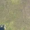
On-line Digital Images |
DP 146065 |
RCAHMS Aerial Photography Digital |
Oblique aerial view of Benie Hoose, Whalsay, looking NW. |
23/9/2012 |
Item Level |
|
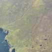 |
On-line Digital Images |
DP 146066 |
RCAHMS Aerial Photography Digital |
General oblique aerial view of Benie Hoose, Whalsay, looking SSW. |
23/9/2012 |
Item Level |
|
 |
On-line Digital Images |
SC 2338743 |
Records of the Ordnance Survey, Southampton, Hampshire, England |
Pettigarth's Field, HU56NE 6, Ordnance Survey index card, Recto |
c. 1958 |
Item Level |
|
 |
On-line Digital Images |
SC 2338744 |
Records of the Ordnance Survey, Southampton, Hampshire, England |
Pettigarth's Field, HU56NE 6, Ordnance Survey index card, Recto |
c. 1958 |
Item Level |
|
 |
On-line Digital Images |
SC 2338745 |
Records of the Ordnance Survey, Southampton, Hampshire, England |
Pettigarth's Field, HU56NE 6, Ordnance Survey index card, Recto |
c. 1958 |
Item Level |
|
 |
On-line Digital Images |
SC 2338746 |
Records of the Ordnance Survey, Southampton, Hampshire, England |
Pettigarth's Field, HU56NE 6, Ordnance Survey index card, Recto |
c. 1958 |
Item Level |
|
|
All Other |
551 166/1/1 |
Records of the Ordnance Survey, Southampton, Hampshire, England |
Archaeological site card index ('495' cards) |
1947 |
Sub-Group Level |
|


