
Pricing Change
New pricing for orders of material from this site will come into place shortly. Charges for supply of digital images, digitisation on demand, prints and licensing will be altered.
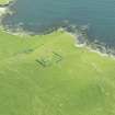
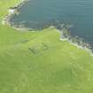
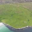
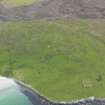
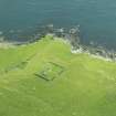
Unst, Sandwick, Framgord Chapel And Cemetery


Burial Ground (Period Unassigned), Cemetery (Period Unassigned), Chapel (Medieval), Cross Slab (Early Medieval)
Site Name Unst, Sandwick, Framgord Chapel And Cemetery
Classification Burial Ground (Period Unassigned), Cemetery (Period Unassigned), Chapel (Medieval), Cross Slab (Early Medieval)
Alternative Name(s) Framgord, Chapel And Gravestones; Our Ladies Kirk
Canmore ID 131
Site Number HP60SW 3
NGR HP 61912 02908
Datum OSGB36 - NGR
Permalink http://canmore.org.uk/site/131


- Council Shetland Islands
- Parish Unst
- Former Region Shetland Islands Area
- Former District Shetland
- Former County Shetland
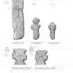
Framgord 1 (St Mary), Sandwick, Unst, Shetland, cruciform stone
Measurements: H 0.63m, W 0.30m
Stone type: schist
Place of discovery: HP 6191 0290
Present location: in the churchyard at Framgord.
Evidence for discovery: recorded by RCAHMS in 1930.
Present condition: good.
Description
This cruciform stone has rounded arms and the side-arms are shorter than the upper arm.
Date: ninth to eleventh centuries.
References: RCAHMS 1946, no 1539; Scott & Ritchie 2009, no 114.
Compiled by A Ritchie 2016
Framgord 2 (St Mary), Sandwick, Unst, Shetland, cruciform stone fragment
Measurements: H 0.76m, W 0.30m +
Stone type: schist
Place of discovery: HP 6191 0290
Present location: in the churchyard at Framgord.
Evidence for discovery: recorded by RCAHMS in 1930.
Present condition: broken.
Description
One vertical side of this stone has sheared off, leaving one intact side-arm, short and with a squared terminal. Part of the upper arm is missing, but it had an expanded shape, as did the shaft.
Date: ninth to eleventh centuries.
References: RCAHMS 1946, no 1539; Scott & Ritchie 2009, no 115.
Compiled by A Ritchie 2016
Framgord 3 (St Mary), Sandwick, Unst, Shetland, cruciform stone
Measurements: H 0.54m, W 0.32m
Stone type: schist
Place of discovery: HP 6191 0290
Present location: in the churchyard at Framgord.
Evidence for discovery: recorded by RCAHMS in 1930.
Present condition: good.
Description
This cruciform stone is a good intact example of the form with expanded upper arm, short side-arms with squared terminals and pointed foot to the shaft.
Date: ninth to eleventh centuries.
References: RCAHMS 1946, no 1539; Scott & Ritchie 2009, no 116.
Compiled by A Ritchie 2016
Framgord 4 (St Mary), Sandwick, Unst, Shetland, cruciform stone
Measurements: H 0.74m, W 0.33m
Stone type: schist
Place of discovery: HP 6191 0290
Present location: in the churchyard at Framgord.
Evidence for discovery: recorded by RCAHMS in 1930.
Present condition:
Description
This stone has short squared arms and a flaring shaft, and it is notable for the addition of a second inner cross carved in relief.
Date: ninth to eleventh centuries.
References: RCAHMS 1946, no 1539; Scott & Ritchie 2009, no 117.
Compiled by A Ritchie 2016
Framgord 5 (St Mary), Sandwick, Unst, Shetland, cruciform stone
Measurements: H 0.62m, W 0.27m
Stone type: schist
Place of discovery: HP 6191 0290
Present location: in the churchyard at Framgord.
Evidence for discovery: recorded by RCAHMS in 1930.
Present condition:
Description
A slender example of a cruciform stone, this has short side-arms, flared expanded upper arm and a straight shaft. There is a tenon-like extension to the op of the upper arm.
Date: ninth to eleventh centuries.
References: RCAHMS 1946, no 1539; Scott & Ritchie 2009, no 118.
Compiled by A Ritchie 2016
Framgord 6 (St Mary), Sandwick, Unst, Shetland, cruciform stone
Measurements: H 0.48m, W 0.20m
Stone type: schist
Place of discovery: HP 6191 0290
Present location: in the churchyard at Framgord.
Evidence for discovery: recorded by RCAHMS in 1930.
Present condition: worn and battered.
Description
This stone has a straight shaft and foreshortened squared arms.
Date: ninth to eleventh centuries.
References: RCAHMS 1946, no 1539; Scott & Ritchie 2009, no 119.
Compiled by A Ritchie 2016
Framgord 7 (St Mary), Sandwick, Unst, Shetland, cross-slab fragment
Measurements: H 0.28m, W 0.34m
Stone type: schist
Place of discovery: HP 6191 0290
Present location: in the churchyard at Framgord.
Evidence for discovery: recorded by RCAHMS in 1930.
Present condition:
Description
This fragment is the top part of a slab carved in relief with a cross. The arms exten to the edges of the slab, but most of the shaft is missing.
Date: eighth or ninth centuries.
References: RCAHMS 1946, no 1539; Scott & Ritchie 2009, no 125.
Compiled by A Ritchie 2016
Framgord 8 (St Mary), Sandwick, Unst, Shetland, recumbent gravestone
Measurements: L 1.22m, W 0.43m
Stone type: schist
Place of discovery: HP 6191 0290
Present location: in the churchyard at Framgord.
Evidence for discovery: recorded by RCAHMS in 1930.
Present condition: worn, and there is damage to the edge of the slab to the left of the shaf of the cross.
Description
This was an almost oval slab, carved in relief with a cross with expanded terminals to the side-arms and a large disc terminal to the upper arm. The foot of the shaft is missing.
Date: tenth to eleventh centuries.
References: RCAHMS 1946, no 1539; Scott & Ritchie 2009, no 128.
Compiled by A Ritchie 2016
HP60SW 3 6191 0291
(HP 6191 0293) Chapel (LB)
(In Ruins) Burial Ground (TI).
OS 6" map, Shetland, 2nd ed., (1900)
A ruined chapel, probably pre-reformation, standing within its burial ground which was still in use in 1878 (Name Book 1878). The chapel is oblong in plan, measuring (internally - not 'overall' as stated by RCAHMS) 36' 10" (11.22m) E-W long from 10' 6" (3.2m) to 11' 9" (3.6m) N-S. The walls which are very irregularly built, varying from 2'11" (0.89m) to 5'2" (1.58m) in thickness, stand to a maximum height of 6' (1.83m) on the west. The only opening traceable is an entrance in the middle of the west gable. Internally there are slight indications of cross-walls at 15'6" (4.72m) from the east and again at 11'6" (16.77m) from the west end. Within the burial-ground, beside some upright slabs carved with rude crosses, lies a recumbent cross-slab as well as five roughly formed coped-stones, each having a central rib on the upper surface. Inside the chapel is a large late 17th or early 18th century armorial stone.
RCAHMS 1946.
Our Ladies Kirk.
Shetland Museum Card Index.
As described. The burial ground is still in use. Name not known locally.
Visited by OS (RL), 4 May 1969.
Cemetery [NAT]
OS 1:10,000 map, 1973.
Antiquarian Observation (1860 - 1870)
Loose drawings of sites in Orkney and Shetland in the Society of Antiquaries Collection (SAS 487), mainly by George Petrie.
Field Visit (24 April 2010)
This chapel and burial-ground, situated in improved pasture about 50m WNW of Kirk Geo, remain as described by RCAHMS in 1946.

