
Leataidh


Rig And Furrow (Medieval) - (Post Medieval), Township (Post Medieval)
Site Name Leataidh
Classification Rig And Furrow (Medieval) - (Post Medieval), Township (Post Medieval)
Alternative Name(s) Balno
Canmore ID 130353
Site Number NC60NE 2.03
NGR NC 6906 0528
NGR Description NC 6906 0528 and NC 6924 0531
Datum OSGB36 - NGR
Permalink http://canmore.org.uk/site/130353


- Council Highland
- Parish Rogart
- Former Region Highland
- Former District Sutherland
- Former County Sutherland
Field Visit (20 June 1995)
NC60NE 2.03 6906 0528 and 6924 0531
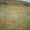
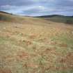
The buildings of this township are situated in bracken-infested ground to either side of the modern track that runs along the terrace above the Abhainn Leataidh. The visible remains comprise two farmsteads, one on the terrace to the SW of the track, the other on the slopes above it to the E, and three smaller buildings or huts. A band of rig cultivation, about 100m broad, extends SE along the terrace from the lower farmstead towards the neighbouring township, described under NC60NE 2.05. In all there are about 7ha of rig, some of it well-preserved with a sharp, high-backed profile. Three unroofed buildings and three enclosure are depicted on the 1st edition of the OS 6-inch map (Sutherland 1879, sheets xcvi)
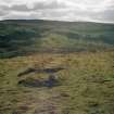
The farmstead to the SW of the track, centred on NC 6906 0528, consists of three buildings, a small hut and two enclosures. The largest building (ROG95 709) measures 23.1m from E to W by 3.3m transversely within a wall 0.7m in thickness which stands up to 0.5m high. It has three compartments, each partition marked by a step down to the W. The entrance is in the S wall, leading into the W compartment, within which there is a byre-drain running to the SW corner. The central compartment has a bedneuk let into its N side, 1.5m deep and 1.8m broad, and there are outshots attached to the E end and the S side of the building. To the NW of this building there is another, measuring 10.4m by 2.2m internally, and divided into two compartments each of which has an entrance on the SSE side (ROG95 708); to the SE of the large building there is a barn (ROG95 710), measuring internally 10.9m from N to S by 2.8m transversely with opposed entrances in its sides and an attached yard to the E. To the S of the barn there is a small rectangular hut (ROG95 711) and across the modern track to the E there is a hut-circle which has been reused as an enclosure by blocking the entrance and building up parts of the wall (NC60NE 2.11).
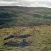
The second farmstead is situated on a higher terrace about 150m to the E at NC 6924 0531. It consists of two buildings and an enclosure. The larger building (ROG95 719) measures 14.2m in length and 2.8m in breadth within rubble walls 0.6m thick and 0.4m high. It has two compartments, with the entrance leading into the lower NW half and a bedneuk, 2.2m deep and 1.7m broad, protruding from the SW side of the upper compartment. There are two outshots added to the NW end and a mound on the SW side may be a midden heap. The second building is to the SE of the first (ROG95 720); it measures internally 7m by 2.8m and has a subrectangular yard on its NW side. The other three structures are all situated on the hillside close to this farmstead - two small buildings to the NW (ROG95 717-8) and a small rubble-built hut to the S (ROG95 721).
(ROG95 708-11, 717-21)
Visited by RCAHMS (SDB) 20 June 1995

