
Following the launch of trove.scot in February 2025 we are now planning the retiral of some of our webservices. Canmore will be switched off on 24th June 2025. Information about the closure can be found on the HES website: Retiral of HES web services | Historic Environment Scotland
Cille Mhuire


Burial Ground (Medieval), Church (Medieval)
Site Name Cille Mhuire
Classification Burial Ground (Medieval), Church (Medieval)
Canmore ID 12960
Site Number NH57NW 2
NGR NH 5222 7721
Datum OSGB36 - NGR
Permalink http://canmore.org.uk/site/12960


- Council Highland
- Parish Alness
- Former Region Highland
- Former District Ross And Cromarty
- Former County Ross And Cromarty
NH57NW 2 5222 7721.
(NH 522 772) Cille Mhuire {NR} (In Ruins)
OS 6"map, Ross-shire, 2nd ed., (1907)
The church is 40' long by 18' broad, within walls 4' thick. The date of construction is not known.
NewStatistical Account (NSA) 1845 (Rev. Alex. Flyter).
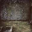
The remains of the church, built of mortared masonry, measure 14.3 m. E-W by 7.0 m. N-S, over walls 0.9 m. thick.
The west gable remains entire and the other three sides vary in height from 1.8 m. to 3.0 m. The doorway is in the south side, at the west end, and there is also a narrow slit window in this wall.
Inside are two flat grave slabs and a small stone font.
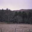
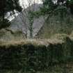
The burial ground is enclosed by a low drystone dyke. It is covered thickly with trees and bushes, and only two modern grave-stones were seen.
Visited by OS (WDJ) 6 May 1963.
"The spelling 'Mhuire' is accepted locally," and conforms to the spelling of the name of the glen 'Gleann Mhuire' which has been verified by the School of Scottish Studies.
OS revision 16 August 1966.
Cille Mhuire {NR} (remains of)
OS 6"map, (1970)
No change to previous field report.
Visited by OS (JB) 18 November 1976.
Reference (1845)
The church is 40' long by 18' broad, within walls 4' thick. The date of construction is not known.
NewStatistical Account (NSA) 1845 (Rev. Alex. Flyter).
Field Visit (6 May 1963)
The remains of the church, built of mortared masonry, measure 14.3 m. E-W by 7.0 m. N-S, over walls 0.9 m. thick.
The west gable remains entire and the other three sides vary in height from 1.8 m. to 3.0 m. The doorway is in the south side, at the west end, and there is also a narrow slit window in this wall.
Inside are two flat grave slabs and a small stone font.
The burial ground is enclosed by a low drystone dyke. It is covered thickly with trees and bushes, and only two modern grave-stones were seen.
Visited by OS (WDJ) 6 May 1963.
Field Visit (18 November 1976)
No change to previous field report.
Visited by OS (JB) 18 November 1976.
Field Visit (15 November 1989)
This church at the N end of Loch Morie is a single-celled structure measuring 14.25m by 6.95m overall. It stands to gable height at the W end and there are a slit window and a door in the S wall. The window is splayed internally and has no dressings, but the door is dressed with chamfered rybats, the top course of which is different to the basal courses. Two partially legible table tombstones are situated inside the church, immediately E of the entrance.
Built into the outer face of the S wall, to the W of the door, 1.7m above the ground, there is a four petalled flower sculpted in low relief on a piece of red sandstone. The surface is partly broken and it is also partly covered in harling. A low bank 4.75m thick, inside a stone facing, encloses the graveyard and church.
In 1549 Queen Mary gave Sir James Buschart the Chapel of Towy (or Tolly) in the diocese of Ross, which had been made vacant by the death of the incumbent (OPS 1855, 473). The chaplaincy of Tolly or Kildermorie cannot be traced any earlier.
The 1st ed. OS 6" map (Ross-shire (1880),52) depicts some enclosures and unroofed buildings on the NW side of the graveyard bank. A heap of rubble is visible in this location but no structures were discernible.
Visited by RCAHMS (PJD) 15 November 1989

