Accessibility

Font Size

100% 150% 200%

Background Colour

Default Contrast
Close Reset

Kenmore Bridge

Road Bridge (Period Unassigned)

Site Name Kenmore Bridge

Classification Road Bridge (Period Unassigned)

Alternative Name(s) Loch Tay; River Tay

Canmore ID 128671

Site Number NN74NE 61.01

NGR NN 77150 45554

Datum OSGB36 - NGR

Permalink http://canmore.org.uk/site/128671

Ordnance Survey licence number AC0000807262. All rights reserved.
Canmore Disclaimer. © Bluesky International Limited 2025. Public Sector Viewing Terms

Toggle Aerial | View on large map

Digital Images

View of the east elevation of the Kenmore Bridge
View of the east elevation of the Kenmore BridgeOblique aerial view of Kenmore Bridge, taken from the S.View of Loch Tay with the Kenmore Bridge over Loch Tay situated in the background, at Kenmore, Perth.
PHOTOGRAPH ALBUM No. 187, (cf PAs 186 and 188) Rev. J.B. MacKenzie of Colonsay Albums,1870, vol.2.
Oblique aerial view of Kenmore centred on the road bridge, church and hotel, and the remains of a crannog with Kenmore Village adjacent, taken from the SSW.Kenmore Bridge
View from SSE showing WSW frontOblique aerial view of Kenmore centred on the road bridge, church and hotel, and the remains of a crannog with Kenmore Village adjacent, taken from the SW.View of the east elevation of the Kenmore Bridge, taken from the north bank of the River TayOblique aerial view of Kenmore Bridge, taken from the SW.Oblique aerial view of Kenmore centred on the road bridge, church and hotel, and the remains of a crannog with Kenmore Village adjacent, taken from the WSW.Oblique aerial view of Kenmore centred on the road bridge, church and hotel, and the remains of a crannog with Kenmore Village adjacent, taken from the WSW.Kenmore, Kenmore Bridge.
View of bridge from East.View looking along the River Tay to the Kenmore Bridge, taken from the grounds of the Kenmore Hotel to the eastOblique aerial view of Kenmore Bridge, taken from the N.Oblique aerial view of Kenmore Bridge, taken from the NW.Oblique aerial view of Kenmore centred on the road bridge, church and hotel, and the remains of a crannog with Kenmore Village adjacent, taken from the SSE.Kenmore, Kenmore Bridge.
Detail of datestone on bridge.Oblique view along the east elevation of the Kenmore Bridge, taken from the north eastView of the east elevation of the Kenmore Bridge, taken from the north bank of the River TayOblique aerial view of Kenmore Bridge, taken from the NNW.Oblique aerial view of Kenmore centred on the road bridge, church and hotel, and the remains of a crannog with Kenmore Village adjacent, taken from the ESE.Drawing of Taymouth Castle and Kenmore.Oblique aerial view of Kenmore centred on the road bridge, church and hotel, and the remains of a crannog with Kenmore Village adjacent, taken from the SW.Oblique aerial view of Kenmore centred on the road bridge, church and hotel, and the remains of a crannog with Kenmore Village adjacent, taken from the ENE.Oblique aerial view of Kenmore centred on the road bridge, church and hotel, and the remains of a crannog with Kenmore Village adjacent, taken from the ESE.Oblique view looking north along the west elevation of the Kenmore Bridge, taken from south westView of Loch Tay and Kenmore.
Oblique aerial view of Kenmore centred on the road bridge, church and hotel, and the remains of a crannog with Kenmore Village adjacent, taken from the W.Kenmore, Kenmore Bridge.
View of bridge from West.Kenmore Bridge
View from N showing ENE front with two small flood-relief arches in foregroundGeneral oblique aerial view of the River Tay centred on the Taymouth Golf Courses, taken from the SW.

Administrative Areas

  • Council Perth And Kinross
  • Parish Kenmore (Perth And Kinross)
  • Former Region Tayside
  • Former District Perth And Kinross
  • Former County Perthshire

Archaeology Notes

NN74NE 61.01 77150 45554

For predecessor bridge (presumably adjacent) see NN74NE 61.00.

NMRS REFERENCE

Architect: John Baxter 1774

EXTERNAL REFERENCE

Scottish Record Office

Building of the Bridge at Kenmore. Payments amounting to #480.12 to MacInnes and Picard, Builders. The remaining sum was to be found in Achalader's accounts.

Noted in the personal account book of the 3rd Earl of Breadalbane.

1772-1775 GD 112/21/81

(Undated) information in NMRS.

Kenmore Bridge, 1774, engineer John Baxter.

Visited and photographed by John Hume, University of Strathclyde, 7 June 1976.

Information from NMRS MS/749/93.

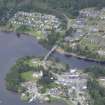
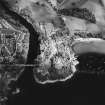
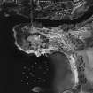
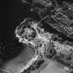
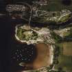
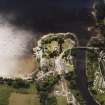
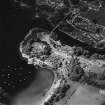
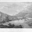
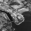
(Location cited at NN 771 456). Kenmore Bridge, built 1774, engineer John Baxter. A very handsome three-span bridge, with segmental arches and arched cutwaters. The piers and arch rings are of dressed stone with rubble spandrels. There are occuli, still open between the spans. The roadway rises in a gentle curve, highlighted by a prominent string course. On the north side are two small flood-relief arches.

J R Hume, 1977.

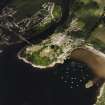
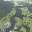
This bridge carries the A827 public road over the River Tay at the NE end of Loch Tay and to the NW of Kenmore village (NN74NE 73). It is depicted, but not noted, on the 1982 edition of the OS 1:10,000 map.

The location assigned to this record defines the midpoint of the structure. The available map evidence indicates that it extends from NN c. 77140 45584 to NN c. 77159 45525.

Information from RCAHMS (RJCM), 25 May 2006.

References

MyCanmore Image Contributions


Contribute an Image

MyCanmore Text Contributions