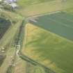
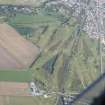
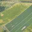
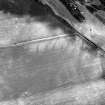
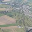
Accessibility

Font Size

100% 150% 200%

Background Colour

Default Contrast
Close Reset

Ardnagrask

Roundhouse (Prehistoric)

Site Name Ardnagrask

Classification Roundhouse (Prehistoric)

Canmore ID 12696

Site Number NH54NW 36

NGR NH 52535 49348

Datum OSGB36 - NGR

Permalink http://canmore.org.uk/site/12696

Ordnance Survey licence number AC0000807262. All rights reserved.
Canmore Disclaimer. © Bluesky International Limited 2025. Public Sector Viewing Terms

Toggle Aerial | View on large map

Digital Images

Oblique aerial view.
Oblique aerial view.Oblique aerial view.Oblique aerial view.Oblique aerial view of the cropmarks of the enclosure, possible sunken floored building and pits, looking E.Oblique aerial view of the cropmarks of the roundhouse, possible sunken floored building and pits, looking S.An oblique aerial view of Muir of Ord, Black Isle, looking NNE.Oblique aerial view of the cropmarks of the enclosure, possible sunken floored buildings and pits, looking E.Oblique aerial view.Oblique aerial view of the cropmarks of the enclosure, possible sunken floored buildings and pits, looking SSE.Ardnagrask, NH54NW 36, Ordnance Survey index card, RectoOblique aerial view.Oblique aerial view.An oblique aerial view of Muir of Ord, Black Isle, looking N.Ardnagrask, NH54NW 36, Ordnance Survey index card, RectoOblique aerial view.Oblique aerial view of the cropmarks of the enclosure, possible sunken floored buildings and pits, looking ESE.Oblique aerial view of the cropmarks of the enclosure, possible sunken floored buildings and pits, looking ESE.Oblique aerial view.Oblique aerial view.

Administrative Areas

  • Council Highland
  • Parish Urray (Ross And Cromarty)
  • Former Region Highland
  • Former District Ross And Cromarty
  • Former County Ross And Cromarty

Archaeology Notes

NH54NW 36 5255 4935.

Tolan notes two large pits outside circle to NW.

M Tolan 1988.

Activities

Aerial Photographic Interpretation (13 February 2014)

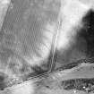
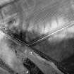
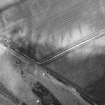
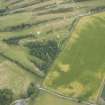
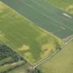
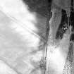
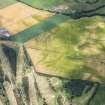
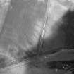
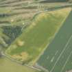
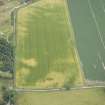
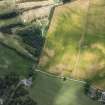
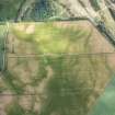
A roundhouse has been recorded as cropmarks on oblique aerial photographs (RCAHMSAP 1982) some 320m NNW of Lower Ardnagrask. Defined by a circle of sixteen pits, it measures about 18m in diameter. Two closely spaced pits outside the circle on the NW may form a porch.

Information from RCAHMS (KMM) 13 February 2014

References

MyCanmore Image Contributions


Contribute an Image

MyCanmore Text Contributions