Accessibility

Font Size

100% 150% 200%

Background Colour

Default Contrast
Close Reset

Lower Ardnagrask

Cemetery (Period Unassigned)(Possible), Linear Feature(S) (Period Unassigned)

Site Name Lower Ardnagrask

Classification Cemetery (Period Unassigned)(Possible), Linear Feature(S) (Period Unassigned)

Canmore ID 12693

Site Number NH54NW 33

NGR NH 5279 4855

Datum OSGB36 - NGR

Permalink http://canmore.org.uk/site/12693

Ordnance Survey licence number AC0000807262. All rights reserved.
Canmore Disclaimer. © Bluesky International Limited 2025. Public Sector Viewing Terms

Toggle Aerial | View on large map

Digital Images

Oblique aerial view centred on the cropmarks of the possible cemetery, macular and linear cropmarks and pits, taken from the WNW.
Oblique aerial view centred on the cropmarks of the possible cemetery, macular and linear cropmarks and pits, taken from the WNW.Lower Ardnagrask, NH54NW 33, Ordnance Survey index card, RectoOblique aerial view centred on the cropmarks of the enclosure, pit-alignment, linear cropmarks, pits and rig with standing stone adjacent, taken from the SE.Oblique aerial view centred on the cropmarks of the possible cemetery, macular and linear cropmarks and pits, taken from the SSW.Oblique aerial view.Oblique aerial view centred on the cropmarks of the enclosure, pit-alignment, linear cropmarks, pits and rig with standing stone adjacent, taken from the SE.Aerial view of Lower Ardnagrask, The Cairns and Muir of Ord Industrial Estate with various cropmarks, Black Isle, looking SE.An oblique aerial view of Muir of Ordnear Muir of Ord, Black Isle, looking S.Oblique aerial view.An oblique aerial view of Muir of Ord, Black Isle, looking NE.Oblique aerial view of new housing development on southern edge of Muir of Ord, Black Isle, looking SE.

Administrative Areas

  • Council Highland
  • Parish Urray (Ross And Cromarty)
  • Former Region Highland
  • Former District Ross And Cromarty
  • Former County Ross And Cromarty

Archaeology Notes

NH54NW 33 5279 4855.

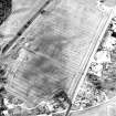
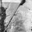
What may be a cemetery has been recorded as cropmarks on oblique aerial photography (RCAHMSAP 1982, 2000) lying about 260m S of Lower Ardnagrask. There are two clusters of small pits, roughly elongated about an axis from WNW-ESE. Beside each cluster of grave pits there are four irregular macular cropmarks of unknown function, but which may be quarries. A linear feature runs roughly E-W between the two clusters of grave pits

Information from RCAHMS (KMM) 16 July 2004

References

MyCanmore Image Contributions


Contribute an Image

MyCanmore Text Contributions