
Bute, Barr Hill


Field System (Period Unassigned), Hut Circle (Prehistoric), Quarry (Period Unassigned), Rig And Furrow (Medieval) - (Post Medieval)
Site Name Bute, Barr Hill
Classification Field System (Period Unassigned), Hut Circle (Prehistoric), Quarry (Period Unassigned), Rig And Furrow (Medieval) - (Post Medieval)
Canmore ID 124782
Site Number NS05SE 32
NGR NS 09717 52143
Datum OSGB36 - NGR
Permalink http://canmore.org.uk/site/124782


- Council Argyll And Bute
- Parish Kingarth
- Former Region Strathclyde
- Former District Argyll And Bute
- Former County Buteshire
NS05SE 32 09717 52143.
NS 097 521. Barr Hill, round structure and field system.
Sponsor: Buteshire Natural History Society
A Hannah and E Proudfoot 1996
NS 0970 5218 Round structure: Located on the east slope of Barr Hill, near foot. This is a stone-built circular structure, c. 8m diameter. Complex system of field dykes and large clearance cairns in vicinity. No records. Probably prehistoric.
Information from Bute Natural History Society Deserted Settlement Survey (1991-9)
(RCAHMS WP000273)
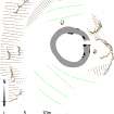
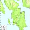
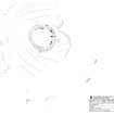
This hut circle is situated on the leading edge of a terrace low down on the E flank of Barr Hill. It measures 8.5m in diameter within a wall reduced to a grass-grown bank 1.5m in thickness and up to 0.4m in height. Both inner and outer facing-stones are intermittently visible in the bank and there is an entrance on the E. The hut circle lies within an extensive field-system containing plots of rig-and-furrow, some of them enclosed, and large clearance cairns. An area of quarrying lies about 65m N of the hut circle.
Visited by RCAHMS (AGCH, IP) 18 March 2009.
Field Visit (1991 - 1999)
NS 097 521. Barr Hill, round structure and field system.
Sponsor: Buteshire Natural History Society
A Hannah and E Proudfoot 1996
NS 0970 5218 Round structure: Located on the east slope of Barr Hill, near foot. This is a stone-built circular structure, c. 8m diameter. Complex system of field dykes and large clearance cairns in vicinity. No records. Probably prehistoric.
Information from Bute Natural History Society Deserted Settlement Survey (1991-9)
(RCAHMS WP000273)
Field Visit (18 March 2009)
This hut circle is situated on the leading edge of a terrace low down on the E flank of Barr Hill. It measures 8.5m in diameter within a wall reduced to a grass-grown bank 1.5m in thickness and up to 0.4m in height. Both inner and outer facing-stones are intermittently visible in the bank and there is an entrance on the E. The hut circle lies within an extensive field-system containing plots of rig-and-furrow, some of them enclosed, and large clearance cairns. An area of quarrying lies about 65m N of the hut circle.
Visited by RCAHMS (AGCH, IP) 18 March 2009.
Measured Survey (19 March 2010)
RCAHMS surveyed the hut circle at Bar Hill, Bute on 19 March 2010 with plane table and alidade at a scale of 1:100. The plan was redrawn in vector graphics software for publication at a scale of 1:500 (Geddes and Hale 2010, 21).

