
Pricing Change
New pricing for orders of material from this site will come into place shortly. Charges for supply of digital images, digitisation on demand, prints and licensing will be altered.
Bute, Port Dornach


Landing Point (Period Unassigned)
Site Name Bute, Port Dornach
Classification Landing Point (Period Unassigned)
Canmore ID 124781
Site Number NS05SE 31
NGR NS 08380 53186
Datum OSGB36 - NGR
Permalink http://canmore.org.uk/site/124781


- Council Argyll And Bute
- Parish Kingarth
- Former Region Strathclyde
- Former District Argyll And Bute
- Former County Buteshire
NS05SE 31 08380 53186.
NS 083 531. Port Dornach, Dunagoil, terminus of ferry to Arran established 1684.
Sponsor: Buteshire Natural History Society
I Maclagan 1995
This site was noted during a coastal zone assessment survey undertaken by CFA Archaeology Ltd to characterise the state of coastal erosion and the threat it poses to cultural heritage sites. A gazetteer in the report included a note of existing records and new sites when discovered. Where the site was located, notes included condition, period/date and recommendations.
Commissioned by The Scape Trust and Firth of Clyde Forum on behalf of Historic Scotland.
Cressey and Johnson 2004
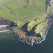
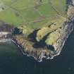
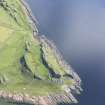
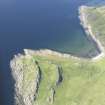
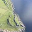
Port Dornach is a natural inlet situated at the S end of Dunagoil Bay. It has a shingle beach and there is no evidence for either a jetty or a slipway.
Visited by RCAHMS (GFG, AGCH) 20 March 2009.
Field Visit (1863)
Reference (1995)
NS 083 531. Port Dornach, Dunagoil, terminus of ferry to Arran established 1684.
Sponsor: Buteshire Natural History Society
I Maclagan 1995
Field Visit (December 2003)
This site was noted during a coastal zone assessment survey undertaken by CFA Archaeology Ltd to characterise the state of coastal erosion and the threat it poses to cultural heritage sites. A gazetteer in the report included a note of existing records and new sites when discovered. Where the site was located, notes included condition, period/date and recommendations.
Commissioned by The Scape Trust and Firth of Clyde Forum on behalf of Historic Scotland.
Cressey and Johnson 2004
Field Visit (20 March 2009)
Port Dornach is a natural inlet situated at the S end of Dunagoil Bay. It has a shingle beach and there is no evidence for either a jetty or a slipway.
Visited by RCAHMS (GFG, AGCH) 20 March 2009.

