
Scheduled Maintenance
Please be advised that this website will undergo scheduled maintenance on the following dates: •
Tuesday 3rd December 11:00-15:00
During these times, some services may be temporarily unavailable. We apologise for any inconvenience this may cause.
Bute, Stuck


Cairn (Period Unassigned)(Possible), Hut (Period Unassigned)(Possible)
Site Name Bute, Stuck
Classification Cairn (Period Unassigned)(Possible), Hut (Period Unassigned)(Possible)
Alternative Name(s) Stuck South
Canmore ID 124775
Site Number NS06NE 44
NGR NS 06094 69606
Datum OSGB36 - NGR
Permalink http://canmore.org.uk/site/124775


- Council Argyll And Bute
- Parish North Bute
- Former Region Strathclyde
- Former District Argyll And Bute
- Former County Buteshire
NS06NE 44 06094 69606.
NS 061 696. Stuck South, two buildings.
Sponsor: Buteshire Natural History Society
A Hannah and E Proudfoot 1996
NS 061 666 Building remains: Located in rough grass field on N side of march burn, close to fence. There are 2 sub-rectangular buildings 100m apart. The lower building is entirely grass covered wall footings, 5.2 x 3.5m over tops, narrowing a bit towards lower end. The upper building is a stone structure with some clearance material added. There is an old dyke close by. No record.
Information from Bute Natural History Society Deserted Settlement Survey (1991-9)
(RCAHMS WP000273)
NS 061 696. Site 196, Stuck (South)
In a rough grass field on the north side of the burn are the remains of two buildings 60m apart. The lower survives as sub-rectangualr earth banked wall-footings 5.3 x 3.5m, narrowing a bit toward the upper end. The upper is a sub-rectangular stone structure to which clearance has been added. there are no previous records and the dating is very uncertain.
E Proudfoot and A Hannah 2000.
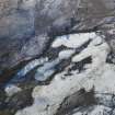
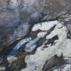
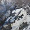
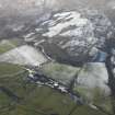
What is probably a hut, less likely some type of cairn, is situated immediately N of an un-named burn in moorland 620m SSW of Stuck farmsteading (NS07SE 21). Roughly rectangular on plan, it measures 3.7m from E to W by 3.1m transversely over a rubble wall, which in part comprises, especially on the S and E, edge-set stones up to 0.8m in height. The grass-grown spread of rubble across the interior of the hut contains a small slab that is set on edge.
The turf building that lies 60m ENE of the hut and is mentioned in previous accounts is described elsewhere (see NS06NE 381).
Visited by RCAHMS (GFG, PJD) 21 April 2009.
Field Visit (1991 - 1999)
NS 061 696. Stuck South, two buildings.
Sponsor: Buteshire Natural History Society
A Hannah and E Proudfoot 1996
NS 061 666 Building remains: Located in rough grass field on N side of march burn, close to fence. There are 2 sub-rectangular buildings 100m apart. The lower building is entirely grass covered wall footings, 5.2 x 3.5m over tops, narrowing a bit towards lower end. The upper building is a stone structure with some clearance material added. There is an old dyke close by. No record.
Information from Bute Natural History Society Deserted Settlement Survey (1991-9)
(RCAHMS WP000273)
NS 061 696. Site 196, Stuck (South)
In a rough grass field on the north side of the burn are the remains of two buildings 60m apart. The lower survives as sub-rectangualr earth banked wall-footings 5.3 x 3.5m, narrowing a bit toward the upper end. The upper is a sub-rectangular stone structure to which clearance has been added. there are no previous records and the dating is very uncertain.
E Proudfoot and A Hannah 2000.
Field Visit (21 April 2009)
What is probably a hut, less likely some type of cairn, is situated immediately N of an un-named burn in moorland 620m SSW of Stuck farmsteading (NS07SE 21). Roughly rectangular on plan, it measures 3.7m from E to W by 3.1m transversely over a rubble wall, which in part comprises, especially on the S and E, edge-set stones up to 0.8m in height. The grass-grown spread of rubble across the interior of the hut contains a small slab that is set on edge.
The turf building that lies 60m ENE of the hut and is mentioned in previous accounts is described elsewhere (see NS06NE 381).
Visited by RCAHMS (GFG, PJD) 21 April 2009.

