Accessibility

Font Size

100% 150% 200%

Background Colour

Default Contrast
Close Reset

Little Rogart

Hut Circle(S) (Prehistoric)

Site Name Little Rogart

Classification Hut Circle(S) (Prehistoric)

Canmore ID 124412

Site Number NC70SW 106.04

NGR NC 7329 0349

NGR Description centred on NC 7329 0349

Datum OSGB36 - NGR

Permalink http://canmore.org.uk/site/124412

Ordnance Survey licence number AC0000807262. All rights reserved.
Canmore Disclaimer. © Bluesky International Limited 2025. Public Sector Viewing Terms

Toggle Aerial | View on large map

Digital Images

Oblique aerial view of Little Rogart, taken from the S.
Oblique aerial view of Little Rogart, taken from the S.Little Rogart, oblique aerial view, taken from the NW, showing an area defined as an archaeological landscape.Little Rogart, oblique aerial view, taken from the SE, showing an area defined as an archaeological landscape.Little Rogart, oblique aerial view, taken from the SE, showing an area defined as an archaeological landscape.Little Rogart, oblique aerial view, taken from the W, showing an area defined as an archaeological landscape.Little Rogart, oblique aerial view, taken from the SE, showing an area defined as an archaeological landscape.Oblique aerial view of the remains of the township of Little Rogart, Strathfleet, taken from the SELittle Rogart, oblique aerial view, taken from the N, showing an area defined as an archaeological landscape.Little Rogart, oblique aerial view, taken from the NW, showing an area defined as an archaeological landscape.Little Rogart, oblique aerial view, taken from the W, showing an area defined as an archaeological landscape.Little Rogart, oblique aerial view, taken from the SE, showing an area defined as an archaeological landscape.Little Rogart, oblique aerial view, taken from the S, showing an area defined as an archaeological landscape.Little Rogart, oblique aerial view, taken from the NE, showing an area defined as an archaeological landscape.Oblique aerial view of Little Rogart, taken from the SSE.Little Rogart, oblique aerial view, taken from the E, showing an area defined as an archaeological landscape.Oblique aerial view of Little Rogart, taken from the SSW.Oblique aerial view of Little Rogart, taken from the S.Little Rogart, oblique aerial view, taken from the NNW, showing an area defined as an archaeological landscape.Little Rogart, oblique aerial view, taken from the NE, showing an area defined as an archaeological landscape.Little Rogart, oblique aerial view, taken from the NW, showing an area defined as an archaeological landscape.Little Rogart, oblique aerial view, taken from the NW, showing an area defined as an archaeological landscape.Little Rogart, oblique aerial view, taken from the WNW, showing an area defined as an archaeological landscape.Little Rogart, oblique aerial view, taken from the SE, showing an area defined as an archaeological landscape.General oblique aerial view of Little Rogart, taken from the NNW.Little Rogart, oblique aerial view, taken from the S, showing an area defined as an archaeological landscape.Little Rogart, oblique aerial view, taken from the WSW, showing an area defined as an archaeological landscape.Little Rogart, oblique aerial view, taken from the SE, showing an area defined as an archaeological landscape.Oblique aerial view of Little Rogart, taken from the S.General oblique aerial view of Little Rogart, taken from the NNW.Little Rogart, oblique aerial view, taken from the NW, showing an area defined as an archaeological landscape.Little Rogart, oblique aerial view, taken from the SW, showing an area defined as an archaeological landscape.Little Rogart, oblique aerial view, taken from the ENE, showing an area defined as an archaeological landscape.

Administrative Areas

  • Council Highland
  • Parish Rogart
  • Former Region Highland
  • Former District Sutherland
  • Former County Sutherland

Activities

Field Visit (6 July 1995)

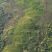
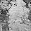
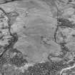
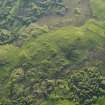
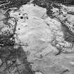
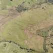
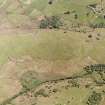
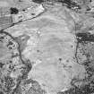
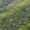
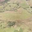
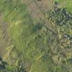
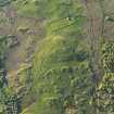
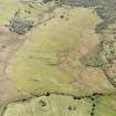
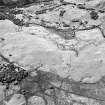
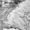
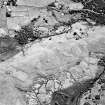
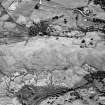
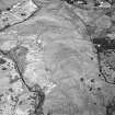
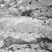
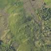
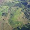
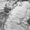
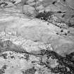
NC70SW 106.04 centred on 7329 0349

There are what may be four hut-circles scattered amongst the core of Little Rogart township (NC70SW 106.04); two of them are partly destroyed by this later activity (ROG95 876, 878, NC 7329 0349 and NC 7321 0342) and survive as incomplete arcs of stone. The hut-circles range from 5.6m to 8.3m in diameter within stone-faced banks 1.3m to 1.8m in thickness. Two of the huts are levelled into the slope (ROG95 874, 876), and two display what are likely to be entrances on the SE (ROG95 854, 874, NC 7317 0334 and NC 7336 and NC 7336 0343).

(ROG95 854, 874, 876, 878)

Visited by RCAHMS (PJD) 6 July 1995

References

MyCanmore Image Contributions


Contribute an Image

MyCanmore Text Contributions